Submarine topography drawing method and device

A technology of terrain drawing and reference position, which is applied in the field of unmanned ships, can solve the problems of low measurement efficiency and measurement accuracy, and achieve the effect of improving accurate measurement and efficiency

Active Publication Date: 2020-04-28
ZHUHAI YUNZHOU INTELLIGENCE TECH COMPANY
View PDF11 Cites 2 Cited by
  • Summary
  • Abstract
  • Description
  • Claims
  • Application Information

AI Technical Summary

Problems solved by technology

[0003] The measurement efficiency and measurement accuracy of the seabed topography drawing scheme in the existing technical schemes are relatively low. Therefore, a scheme for sea (lake or river) bottom topography measurement is urgently needed at present.

Method used


Image

  • Submarine topography drawing method and device
  • Submarine topography drawing method and device

Examples


Embodiment Construction

[0027] In order to make the above objects, features and advantages of the present invention more comprehensible, the present invention will be further described in detail below in conjunction with the accompanying drawings and specific embodiments. Apparently, the described embodiments are some, but not all, embodiments of the present invention. Based on the embodiments of the present invention, all other embodiments obtained by persons of ordinary skill in the art without creative efforts fall within the protection scope of the present invention.

[0028] The embodiments of the present invention will be described in detail below.

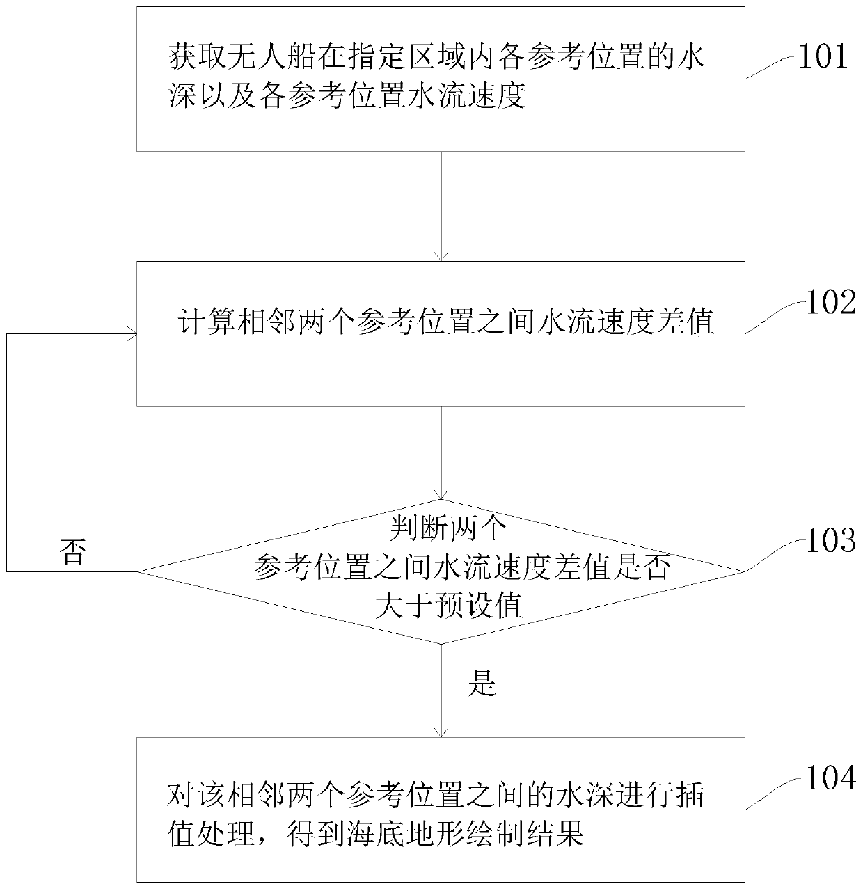
[0029] refer to figure 1 , figure 1 It shows a flow chart of a seabed terrain rendering method according to an embodiment of the present invention, which may specifically include the following steps:

[0030] Step 101: Obtain the water depth of each reference position of the unmanned ship in the designated area and the water velocity of each ref...


PUM


Abstract

The invention discloses a submarine topography drawing method and a device. The method comprises the following steps of: obtaining the water depth of each reference position of the unmanned ship in the designated area and the water flow speed of each reference position; and calculating a water flow speed difference value between two adjacent reference positions, judging whether the water flow speed difference value between the two reference positions is greater than a preset value, and if the water flow speed difference value between the two adjacent reference positions is greater than the preset value, performing interpolation processing on the water depth between the two adjacent reference positions to obtain a submarine topography drawing result. The submarine topography drawing methodprovided by the embodiment of the invention greatly improves the submarine topography accurate measurement and efficiency.

Description

technical field [0001] The invention relates to the field of unmanned ships, in particular to a method and device for mapping seabed topography. Background technique [0002] Unmanned ship is a new product that utilizes modern unmanned technology and multi-field technology fusion, and has obvious advantages over traditional ships. It can navigate on the water surface according to preset tasks without remote control, with the help of precise satellite positioning and its own sensing, and is widely used in surveying and mapping, hydrology and water quality monitoring. [0003] The seabed terrain mapping scheme in the existing technical schemes has low measurement efficiency and measurement accuracy. Therefore, a scheme for sea (lake or river) bottom topography measurement is urgently needed at present. Contents of the invention [0004] In view of the above problems, embodiments of the present invention are proposed in order to provide a seabed terrain mapping method and de...

Claims


Application Information

Patent Timeline
Patent Type & Authority Applications(China)
IPC IPC(8): G06T17/05G06F16/29
CPCG06T17/05G06F16/29
Inventor 黄坚曾宏
Owner ZHUHAI YUNZHOU INTELLIGENCE TECH COMPANY
Why Eureka
Try Eureka