
A method and system for urban three-dimensional surveying and mapping based on drones

A drone and three-dimensional technology, applied in the field of urban three-dimensional surveying and mapping methods and systems, can solve problems such as time-consuming, restricting the efficiency and cost of three-dimensional surveying and mapping

Active Publication Date: 2022-06-28
INFORMATION SCI RES INST OF CETC
View PDF8 Cites 0 Cited by
  • Summary
  • Abstract
  • Description
  • Claims
  • Application Information

AI Technical Summary

Problems solved by technology

[0003] However, the following problems still exist. First, the process of surveying and mapping often requires human participation such as manual remote control or target course setting, and human judgment is required to determine the quality of 3D surveying and mapping and carry out follow-up operations. These factors greatly restrict the efficiency of 3D surveying and mapping. and cost; second, the generation of surveying and mapping models is often based on a large number of images taken by drones, especially for city-level scenes, the amount of data is large, and it takes a relatively long time to obtain a 3D map through offline processing

Method used


Image

  • A method and system for urban three-dimensional surveying and mapping based on drones
  • A method and system for urban three-dimensional surveying and mapping based on drones
  • A method and system for urban three-dimensional surveying and mapping based on drones

Examples


Embodiment Construction

[0070] The present invention will be further described in detail below in conjunction with the accompanying drawings and embodiments. It should be understood that the specific embodiments described here are only used to explain the present invention, but not to limit the present invention. In addition, it should be noted that, for the convenience of description, only some structures related to the present invention are shown in the drawings but not all structures.

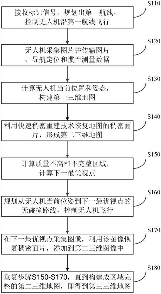
[0071] see figure 1 , showing a flow chart of the UAV-based urban three-dimensional surveying and mapping method according to the present invention,

[0072] Specifically include the following steps:

[0073] This method is used in unmanned aerial vehicle, and described unmanned aerial vehicle comprises unmanned aerial vehicle main body, cloud platform, image acquisition module such as optical camera, navigation positioning module such as GPS or Beidou navigation, and inertial measurement unit.

[0074] Step S11...


PUM


Abstract

A method and system for urban three-dimensional surveying and mapping based on drones, the method comprising: planning a first route, collecting images along the first route, and constructing a first three-dimensional map; restoring the dense surface of the first three-dimensional map by means of rapid dense reconstruction slice to form a second three-dimensional map; calculate the incomplete and poor-quality area for the second three-dimensional map, and calculate the next optimal viewpoint that can capture the area, and generate a collision-free path according to the next optimal viewpoint; The second three-dimensional map is generated from the image collected at the optimal viewpoint, and the above steps are repeated until the second three-dimensional map with a complete area is constructed, that is, the third three-dimensional map is obtained. The invention can autonomously carry out three-dimensional surveying and mapping, construct maps in real time, and finally form a complete three-dimensional map with texture information. Compared with the prior art, the present invention can automatically find and complete incomplete areas, and form a three-dimensional map in real time.

Description

technical field [0001] The present invention relates to the field of map surveying and mapping, in particular to a method and system for urban three-dimensional surveying and mapping based on drones. Background technique [0002] The traditional 3D surveying and mapping method mainly relies on manual means, which has a long construction period, high cost and single result form. In recent years, with the improvement of the performance of small drones and cameras, photogrammetry technology based on aerial photography images has been widely used. It takes the images captured by small drones as input, analyzes the images, and calculates the three-dimensional information of the city through computer vision. UAV-based three-dimensional mapping technology including oblique photography simplifies the operational complexity of surveying and mapping and saves labor costs. [0003] However, the following problems still exist. First, the process of surveying and mapping often requires...

Claims


Application Information

Patent Timeline
Patent Type & Authority Patents(China)
IPC IPC(8): G01C15/00G01C11/00G01C21/16G01S19/47
CPCG01C15/00G01C11/00G01C21/165G01S19/47
Inventor 孟繁乐王蓉查文中孟祥瑞
Owner INFORMATION SCI RES INST OF CETC
Learn More