
Obstacle map construction method

A map construction and obstacle technology, applied in two-dimensional position/channel control and other directions, can solve problems such as road surface prediction that cannot be moved by robots

Active Publication Date: 2021-04-20
GUANGDONG UNIV OF TECH
View PDF6 Cites 0 Cited by
  • Summary
  • Abstract
  • Description
  • Claims
  • Application Information

AI Technical Summary

Problems solved by technology

[0003] In the process of building an obstacle map, ground smoothness detection is an important part, but most of the existing ground smoothness detection methods require complex mechanical structures to directly measure the ground smoothness data, or use mobile robots to move The ground smoothness of the trajectory is recorded, and it is impossible to predict the real-time smoothness of the road that the mobile robot will pass

Method used


Image

  • Obstacle map construction method
  • Obstacle map construction method
  • Obstacle map construction method

Examples


Embodiment Construction

[0055] The present invention will be further described below in conjunction with specific embodiment:

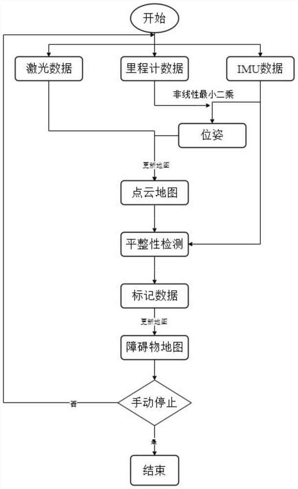
[0056] Such as figure 1 As shown, a kind of obstacle map construction method described in the embodiment of the present invention, the general process is as follows: 1) first obtain the optimal pose at each moment in the process of advancing the mobile robot equipped with multiple laser ranging modules, and then Combining laser data to obtain a point cloud map that collects all laser ranging data;

[0057] In this step, by combining the IMU and the visual odometer, nonlinear least squares is used to obtain the optimal pose of the mobile robot at each moment during the forward process. The specific process is as follows:

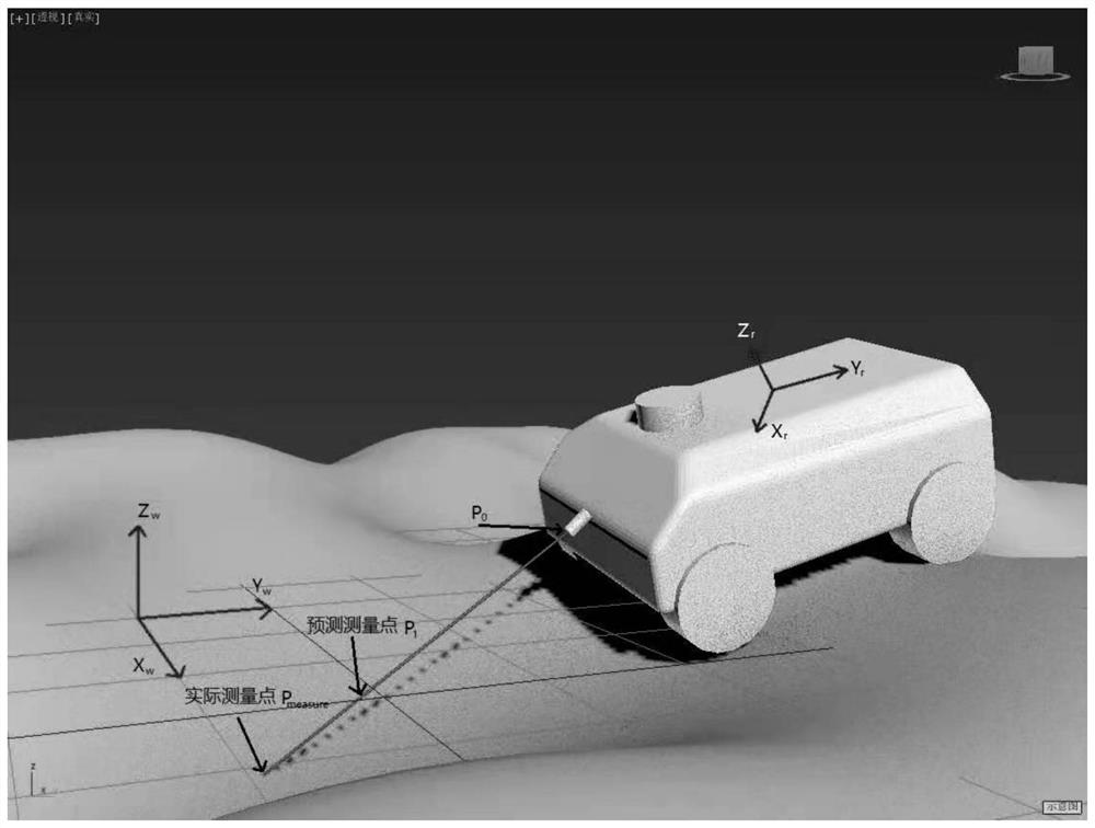
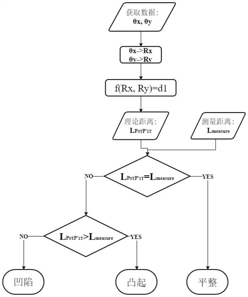
[0058] Since the laser ranging module is a multi-line laser ranging module, set P 0 ,P 1 point as a reference, then each extended line of laser light or scanning laser light at different times is consistent with the reference point P 0 ,P 1 There is a ...


PUM


Abstract

The invention discloses an obstacle map construction method, which comprises the following steps: solving the optimal pose of a mobile robot at each moment in the advancing process, acquiring a point cloud map integrating all laser ranging data in combination with laser data, performing flatness detection on all the laser ranging data of the point cloud map, marking according to a detection result, and after all the laser ranging data are marked, screening out all the concave and convex obstacles according to the labels so as to obtain an obstacle map for highlighting the concave and convex obstacles. According to the method, real-time flatness prediction can be carried out on the road surface to be passed by the mobile robot, so that an obstacle map for highlighting concave and convex obstacles is constructed in real time.

Description

technical field [0001] The invention relates to the technical field of laser ranging, in particular to a method for constructing an obstacle map. Background technique [0002] For mobile robots, in indoor environments, they often encounter objects that cannot be detected by lidar, such as thresholds, stairs, or other sundries; in outdoor environments, the road surface is often uneven, and mobile robots pass through uneven road When the vibration is transmitted to the internal circuits and sensors of the mobile robot, it is easy to damage the mobile robot. Therefore, it is necessary to construct an obstacle map that highlights concave and convex obstacles. [0003] In the process of building an obstacle map, ground smoothness detection is an important part, but most of the existing ground smoothness detection methods require complex mechanical structures to directly measure the ground smoothness data, or use mobile robots to move The ground smoothness of the trajectory is re...

Claims


Application Information

Patent Timeline
Patent Type & Authority Applications(China)
IPC IPC(8): G05D1/02
CPCY02T10/40
Inventor 程天明苏成悦
Owner GUANGDONG UNIV OF TECH
Learn More