Space debris real-time astronomical positioning method based on pointing error automatic measurement

A technology for space debris and astronomical positioning, applied in astronomical navigation, measurement devices, surveying and navigation, etc., and can solve problems such as the influence of correction accuracy and the low correction accuracy of telescope pointing errors.

Active Publication Date: 2020-05-15
ZIJINSHAN ASTRONOMICAL OBSERVATORY CHINESE ACAD OF SCI
View PDF4 Cites 2 Cited by
  • Summary
  • Abstract
  • Description
  • Claims
  • Application Information

AI Technical Summary

Problems solved by technology

Even so, in the sky area with a low elevation angle, the correction accuracy of the telescope

Method used


Image

  • Space debris real-time astronomical positioning method based on pointing error automatic measurement
  • Space debris real-time astronomical positioning method based on pointing error automatic measurement
  • Space debris real-time astronomical positioning method based on pointing error automatic measurement

Examples


Embodiment Construction

[0067] In order to better understand the technical content of the present invention, specific embodiments are given together with the attached drawings for description as follows.

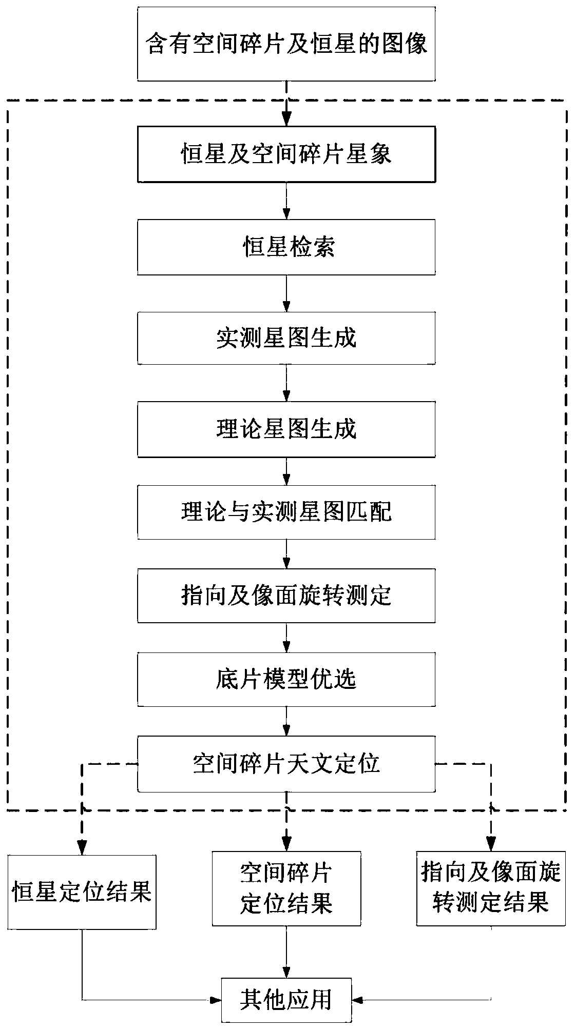
[0068] combine figure 1 , the present invention refers to a real-time astronomical positioning method for space debris based on automatic determination of pointing errors, said real-time astronomical positioning method comprising the following steps:

[0069] S1: Receive at least one frame of images including space debris and background stars, and obtain star image information of stars and space debris within the preset detection threshold on the image, and the star image information includes two-dimensional plane coordinates of each star and space debris ( x, y), the number of pixels, the sum of gray scales, and sort all the constellations in the order of decreasing number of pixels; among them, the upper left corner of the image is set as the coordinate origin (0, 0), and the right side of the im...


PUM


Abstract

The invention discloses a space debris real-time astronomical positioning method based on pointing error automatic measurement. The space debris real-time astronomical positioning method comprises forming a fixed star and a space debris star image; performing fixed star retrieval; generating a theoretical star map; generating an actual measurement star map; matching the theoretical star map with the actually measured star map; pointing and image plane rotation measurement; optimizing a negative film model; performing space debris astronomical localization. According to the invention, the negative film model can be automatically optimized according to the size of the observation field of view, the image center direction and the image plane rotation angle are automatically measured accordingto the given time and image center direction on the image, automatic matching of fixed star theoretical coordinates and actually measured coordinates is realized, and thus real-time astronomical positioning of space debris is realized.

Description

technical field [0001] The invention relates to the technical field of space debris positioning, in particular to a real-time astronomical positioning method for space debris based on automatic measurement of pointing errors. Background technique [0002] In many fields such as scientific research and military affairs, it is necessary to monitor space debris. On the one hand, it measures the position and changes of space debris in the sky at each observation moment, and determines the orbit of space debris, so as to obtain accurate information about space debris. Based on this requirement, accurate measurement of space debris is a very important basic link. Without accurate measurement of space debris, space debris orbit identification, cataloging orbit determination, and precise orbit determination cannot be realized. [0003] There are two methods to accurately measure the position of space debris: absolute positioning and relative positioning. Among them, absolute positi...

Claims


Application Information

Patent Timeline
IPC IPC(8): G01C21/02
CPCG01C21/025
Inventor 张晓祥王鲲鹏惠建江
Owner ZIJINSHAN ASTRONOMICAL OBSERVATORY CHINESE ACAD OF SCI
Why Eureka
Try Eureka