Multi-source remote sensing data classification method for extracting classification sample points based on unmanned aerial vehicle

A technology of remote sensing data and classification methods, which is applied to computer parts, instruments, character and pattern recognition, etc., can solve the problems that hinder the development of large-scale surface classification research, the high cost of manpower, material resources and time, and the difficulty of obtaining it. Achieve the effect of reducing time consumption, excellent precision, and expanding collection time

Active Publication Date: 2020-06-05
GUIZHOU INST OF PRATACULTURE
View PDF8 Cites 10 Cited by
  • Summary
  • Abstract
  • Description
  • Claims
  • Application Information

AI Technical Summary

Problems solved by technology

The existing land surface type classification methods are becoming more and more accurate, but it is difficult to obtain field-measured classification sample points as a necessary input condition for any classification model
Especially on a large scale, if the classification sample points are collected through traditional field surveys, the cost of manpower, material resources and time will be extremely high, which seriously hinders the development of large-scale surface classification research.

Method used


Image

  • Multi-source remote sensing data classification method for extracting classification sample points based on unmanned aerial vehicle
  • Multi-source remote sensing data classification method for extracting classification sample points based on unmanned aerial vehicle
  • Multi-source remote sensing data classification method for extracting classification sample points based on unmanned aerial vehicle

Examples


Embodiment Construction

[0057] The following will clearly and completely describe the technical solutions in the embodiments of the present invention with reference to the accompanying drawings in the embodiments of the present invention. Obviously, the described embodiments are only some, not all, embodiments of the present invention. Based on the embodiments of the present invention, all other embodiments obtained by persons of ordinary skill in the art without making creative efforts belong to the protection scope of the present invention.

[0058] see Figure 7 , the embodiment of the present invention provides a multi-source remote sensing data classification method based on unmanned aerial vehicles to extract classification sample points, the method includes:

[0059] Step S1, uniformly extract classified sample points from the aerial photos of the UAV, and prepare for calibration of each type of sample points; wherein, the types of sample points to be calibrated include: farmland and grassland...


PUM


Abstract

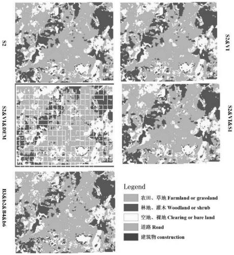
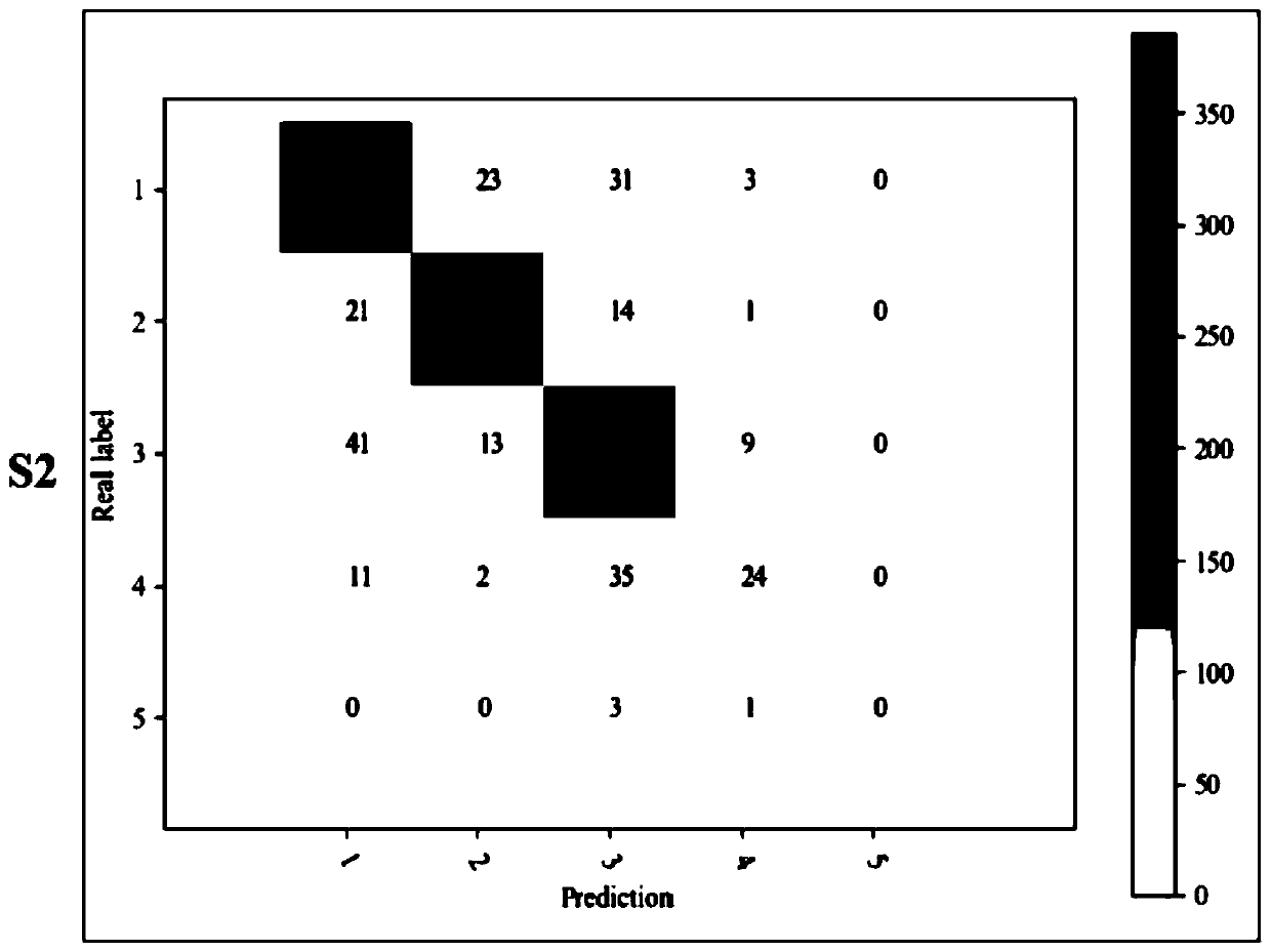
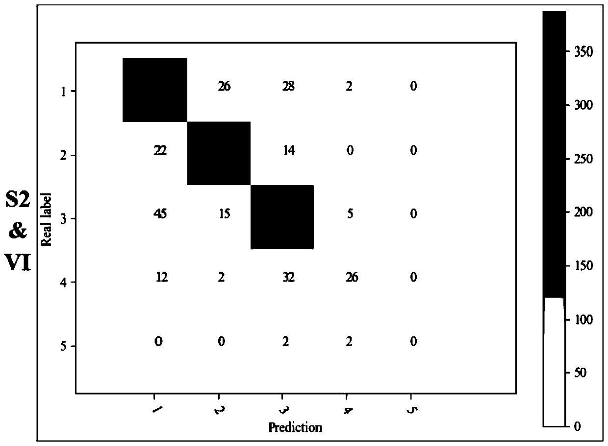
The invention discloses a multi-source remote sensing data classification method for extracting classification sample points based on an unmanned aerial vehicle, and the method comprises the steps: uniformly extracting the classification sample points from aerial photos of the unmanned aerial vehicle, and carrying out the preparation and calibration of each type of sample points; obtaining a classified remote sensing data set, performing image processing on the remote sensing data set, and performing geographic positioning on the classified sample points according to the classified remote sensing image data set, wherein the classified remote sensing data set comprises a microwave data Sentinel-1 data set, a multispectral Sentinel-2 data set, a vegetation index data set based on the Sentinel-2 data set and a digital elevation model data set; and obtaining a classification result by utilizing a random forest classification model through the classification sample points with the geographic space information positioning. According to the multi-source remote sensing data random forest classification method based on the classification sample points extracted by the unmanned aerial vehicle, the earth surface type classification drawing process can be rapidly, effectively and cheaply realized; and meanwhile, after the influence of edge classification sample points is eliminated, the classification precision is obviously improved, and particularly, the precision of the kappa coefficient is better.

Description

technical field [0001] The present invention relates to the technical field of remote sensing data classification, and more specifically relates to a multi-source remote sensing data classification method based on unmanned aerial vehicles to extract classification sample points. Background technique [0002] The global karst landform has a large area, and a considerable part of the global population depends on the aquifer in the karst area for water. The karst ecosystem is very fragile and is particularly vulnerable to environmental changes, resulting in the destruction of surface vegetation in the area, which in turn causes the surface landscape to degenerate into bare soil areas or even rocky areas. This rocky desertification phenomenon is another Serious ecosystem short-term irreversible process. The area of ​​rocky desertification is relatively large in the karst areas of Southwest my country. Among them, Guizhou Province, which is the center of karst, degenerated into ...

Claims


Application Information

Patent Timeline
Patent Type & Authority Applications(China)
IPC IPC(8): G06K9/62G06K9/00
CPCG06V20/13G06F18/24323G06F18/214
Inventor 王志伟宜树华张文阮玺睿宋雪莲王茜钟理岳广阳陈建军秦彧
Owner GUIZHOU INST OF PRATACULTURE
Why Eureka
Try Eureka