
Early warning method and system based on satellite data fusion mountain fire monitoring and fire behavior deduction

A technology based on satellite data and mountain fires, applied in the field of early warning based on satellite data fusion of mountain fire monitoring and fire deduction, can solve the problems of difficult to achieve comprehensive monitoring of mountain fires, failure to grasp the development trend of mountain fires, loss of life and property, etc.

Inactive Publication Date: 2020-06-19
云南电网有限责任公司输电分公司
View PDF5 Cites 1 Cited by
  • Summary
  • Abstract
  • Description
  • Claims
  • Application Information

AI Technical Summary

Problems solved by technology

[0002] Under the trend of global warming, the probability of wildfires is gradually increasing. In addition, my country has a vast territory and complex terrain. It is difficult to achieve the purpose of comprehensive monitoring of wildfires only through manual monitoring. Currently, watchtowers, artificial field observations, and drones are used to monitor wildfires. Carrying out mountain fire monitoring through cruises and other methods cannot achieve continuous monitoring of all areas in all directions at all times, resulting in the rapid development of some mountain fires without any measures being taken, and the development trend of mountain fires cannot be grasped in time. Incalculable loss of life and property

Method used


Image

  • Early warning method and system based on satellite data fusion mountain fire monitoring and fire behavior deduction
  • Early warning method and system based on satellite data fusion mountain fire monitoring and fire behavior deduction
  • Early warning method and system based on satellite data fusion mountain fire monitoring and fire behavior deduction

Examples


Embodiment Construction

[0035] The following will clearly and completely describe the technical solutions in the embodiments of the present invention with reference to the accompanying drawings in the embodiments of the present invention. Obviously, the described embodiments are only some, not all, embodiments of the present invention. Based on the embodiments of the present invention, all other embodiments obtained by persons of ordinary skill in the art without making creative efforts belong to the protection scope of the present invention.

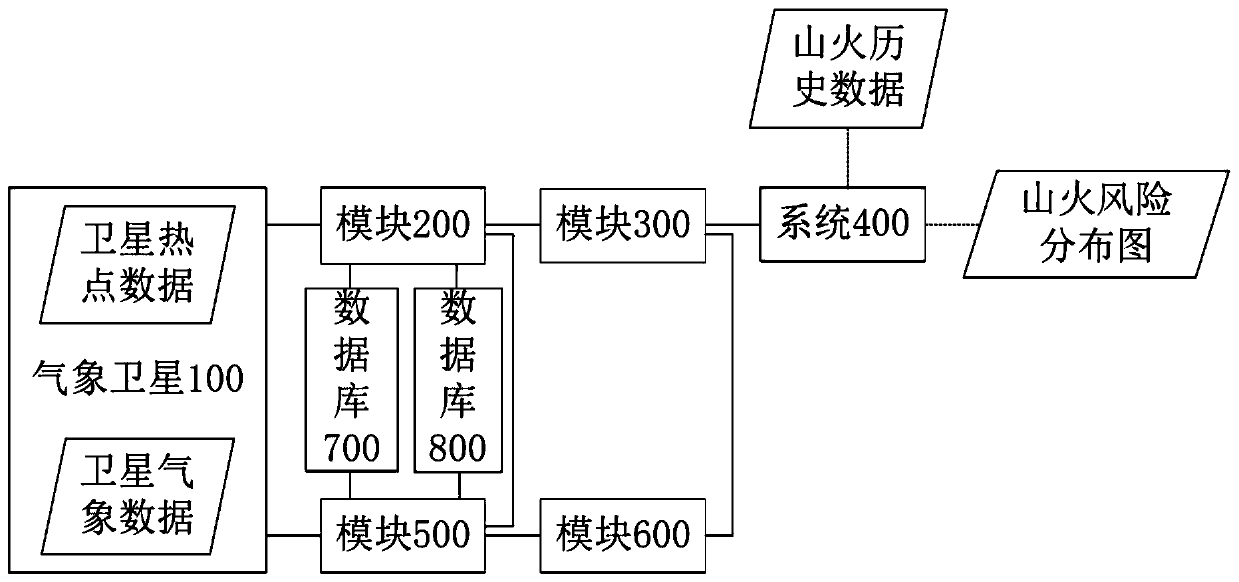
[0036] see Figure 1-5 , the present invention provides a technical solution:

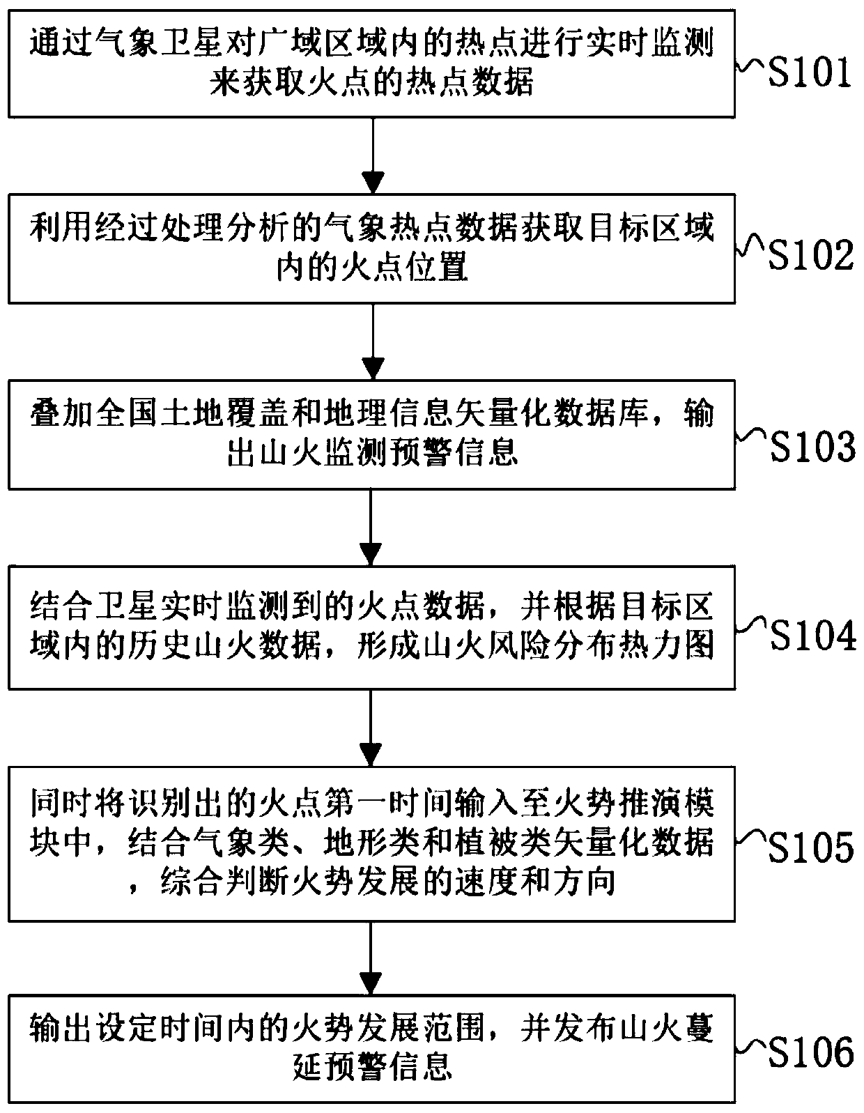
[0037] An early warning method based on satellite data fusion of mountain fire monitoring and fire deduction, comprising the following steps:

[0038] S101: Obtain the hot spot data of the fire point through real-time monitoring of the hot spot in the wide area by the meteorological satellite in the geostationary orbit, and update the data every 10 minutes;

[0039] S102: Using t...


PUM


Abstract

The invention relates to an early warning method and system based on satellite data fusion mountain fire monitoring and fire behavior deduction. The method comprises the following steps: firstly, acquiring a fire point position in a target area by utilizing processed and analyzed meteorological hot spot data, outputting a forest fire monitoring and early warning file according to a vegetation classification condition at the target position, issuing early warning information, and forming a forest fire risk distribution thermodynamic diagram according to forest fire historical data; meanwhile, inputting the monitored longitude and latitude of the fire point into the fire behavior deduction module, judging the fire behavior development speed and direction comprehensively according to the weather, landform and land cover data of the fire point position, and outputting and publishing the fire behavior development range within the set time. The forest fire condition of the target area can bemonitored in a large-scale and all-weather mode through the satellite remote sensing technology, the neutral period existing in manual on-site observation can be made up, early warning is conducted in the early stage of forest fire development, the forest fire spreading range is deduced and predicted, and first-hand data information is provided for forest fire protection and related departments to take measures.

Description

technical field [0001] The invention relates to the technical field of mountain fire monitoring and fire deduction, in particular to an early warning method and system based on satellite data fusion for mountain fire monitoring and fire deduction. Background technique [0002] Under the trend of global warming, the probability of wildfires is gradually increasing. In addition, my country has a vast territory and complex terrain. It is difficult to achieve the purpose of comprehensive monitoring of wildfires only through manual monitoring. Currently, watchtowers, artificial field observations, and drones are used to monitor wildfires. Carrying out mountain fire monitoring by means of patrolling cannot achieve uninterrupted monitoring of all areas at all times and in all directions. As a result, some mountain fires develop rapidly without any measures being taken, and the development trend of mountain fires cannot be grasped in time. Cause incalculable loss of life and property....

Claims


Application Information

Patent Timeline
IPC IPC(8): G08B17/00G08B17/12G08B21/18
CPCG08B17/00G08B17/005G08B17/12G08B21/182
Inventor 黄俊波王洪武李俊鹏文刚徐真杨亮蔡澍雨
Owner 云南电网有限责任公司输电分公司
Learn More