Method and device for helicopter ground proximity warning
A helicopter and warning indication technology, applied in the field of helicopters, can solve the problem of lack of ground proximity warning methods for helicopters, and achieve the effect of improving data processing efficiency and saving computing time
- Summary
- Abstract
- Description
- Claims
- Application Information
AI Technical Summary
Problems solved by technology
Method used
Image
Examples
Embodiment 1
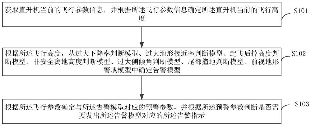
[0023] see figure 1 The helicopter ground proximity warning method shown in, the helicopter ground proximity warning method provided in this embodiment includes:
[0024] Step S101 , acquiring the current flight parameter information of the helicopter, and determining the current flight altitude of the helicopter according to the flight parameter information.
[0025] In this embodiment, the flight parameter information is used to indicate the flight status of the helicopter, or the working status of various components of the helicopter during flight. For example, flight parameter information includes latitude and longitude information representing the flight position of the helicopter, radio altitude information and barometric altitude information representing the flight altitude of the helicopter, airspeed information representing the flight speed of the helicopter, and landing gear status light information representing the state of the helicopter's landing gear. The flight...
Embodiment 2
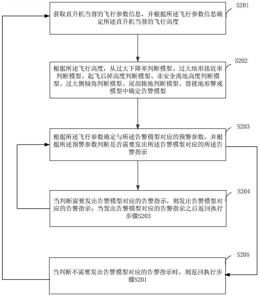
[0048] see figure 2 The helicopter ground proximity warning method shown in, the helicopter ground proximity warning method provided in this embodiment includes:
[0049] Step S201, acquiring the current flight parameter information of the helicopter, and determining the current flight altitude of the helicopter according to the flight parameter information.
[0050] In this embodiment, the flight parameters may include a first sub-parameter used to represent the current air pressure altitude change rate of the helicopter, a second sub-parameter used to represent the current radio altitude of the helicopter, and a third sub-parameter used to represent the current airspeed of the helicopter, The fourth sub-parameter used to represent the current barometric altitude of the helicopter, the fifth sub-parameter used to represent the current roll angle of the helicopter, the sixth sub-parameter used to represent the current pitch angle of the helicopter, and the seventh sub-paramet...
Embodiment 3
[0146] see Figure 4 The helicopter ground proximity warning device shown in, the helicopter ground proximity warning device provided in this embodiment includes:
[0147] The flight height determination module 301 is used to obtain the current flight parameter information of the helicopter, and determine the current flight height of the helicopter according to the flight parameter information.
[0148] The warning model determination module 302 is used to judge the model from the excessive descent rate, the excessive terrain approach rate judgment model, the height judgment model after take-off, the unsafe ground clearance judgment model, the excessive roll angle judgment model, The warning model is determined in the tail collision judgment model and the forward-looking terrain warning model.
[0149] The warning indication module 303 is configured to determine the warning parameters corresponding to the warning model according to the flight parameters, and judge whether to ...
PUM
 Abstract
Description
Claims
Application Information
 - R&D
- Intellectual Property
- Life Sciences
- Materials
- Tech Scout
- Unparalleled Data Quality
- Higher Quality Content
- 60% Fewer Hallucinations
Browse by: Latest US Patents, China's latest patents, Technical Efficacy Thesaurus, Application Domain, Technology Topic, Popular Technical Reports.
© 2025 PatSnap. All rights reserved.Legal|Privacy policy|Modern Slavery Act Transparency Statement|Sitemap|About US| Contact US: help@patsnap.com


