A vegetation height inversion method and device based on two SAR images
A high-level inversion and vegetation technology, applied in the direction of measuring devices, radio wave reflection/re-radiation, instruments, etc., can solve the problems of difficulty in obtaining accurate multi-view SAR images, achieve wide application range, easy implementation, and improve accuracy Effect
- Summary
- Abstract
- Description
- Claims
- Application Information
AI Technical Summary
Problems solved by technology
Method used
Image
Examples
Embodiment Construction
[0051] The following is a detailed description of the embodiments of the present invention. This embodiment is carried out based on the technical solution of the present invention, and provides detailed implementation methods and specific operation processes to further explain the technical solution of the present invention.
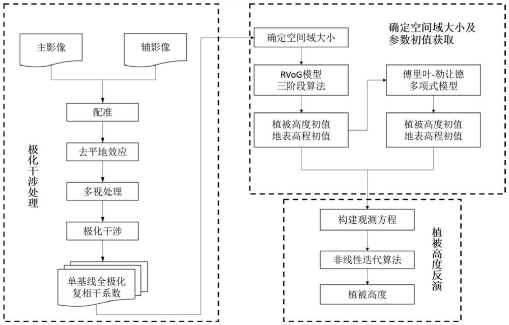
[0052] This embodiment provides a vegetation height inversion method based on two-scene SAR images and Fourier-Legendre polynomials, such as figure 1 described, including the following steps:
[0053] Step S10, preprocessing the two SAR images to obtain the observed value of the full polarization complex coherence coefficient;
[0054] First, two SAR images about the vertical structure of the vegetation cover are obtained, and then the registration, flat phase phase removal, multi-view processing, polarization interference and other steps are sequentially performed, and finally P complex coherence coefficients of each pixel of the SAR image are obtained ...
PUM
 Abstract
Description
Claims
Application Information
 - R&D
- Intellectual Property
- Life Sciences
- Materials
- Tech Scout
- Unparalleled Data Quality
- Higher Quality Content
- 60% Fewer Hallucinations
Browse by: Latest US Patents, China's latest patents, Technical Efficacy Thesaurus, Application Domain, Technology Topic, Popular Technical Reports.
© 2025 PatSnap. All rights reserved.Legal|Privacy policy|Modern Slavery Act Transparency Statement|Sitemap|About US| Contact US: help@patsnap.com


