Network geographic information service system based on three-dimensional model tiles

A geographic information service and 3D model technology, applied in geographic information databases, 3D modeling, image data processing, etc., can solve the problems of fewer types of loaded data, slow loading of 3D models, and low efficiency, so as to increase user experience and improve The effect of loading speed and efficiency

Active Publication Date: 2020-06-30
POWER CHINA KUNMING ENG CORP LTD
View PDF7 Cites 12 Cited by
  • Summary
  • Abstract
  • Description
  • Claims
  • Application Information

AI Technical Summary

Problems solved by technology

[0005] The purpose of the present invention is to provide a network geographic information service system based on 3D model tiles, which solves the problems of slow loading of 3D models, low efficiency and few types of loaded data in the prior art

Method used


Image

  • Network geographic information service system based on three-dimensional model tiles

Examples


Embodiment Construction

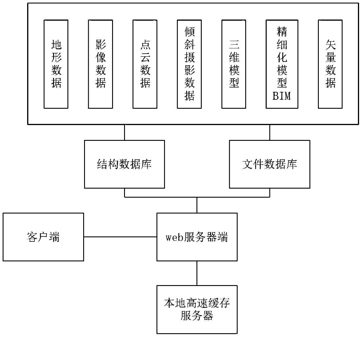
[0022] In order to make the object, technical solution and advantages of the present invention clearer, the present invention will be further described in detail below in conjunction with the accompanying drawings and embodiments. It should be understood that the specific embodiments described here are only used to explain the present invention, not to limit the present invention.

[0023] figure 1 shows a structural block diagram of the present invention, refer to figure 1 : A network geographic information service system based on 3D model tiles, including: a client, a structure database, a file database, a web server, and a local cache server. The client is connected to the web server, the web server is connected to the structure database, the file database and the local cache server, the structure database is connected to the web server, and the file database is connected to the web server.

[0024] Among them, the structure database is responsible for using slicing techn...


PUM


Abstract

The invention discloses a network geographic information service system based on three-dimensional model tiles. The network geographic information service system comprises a client, a structure database, a file database, a web server and a local cache server. The client is connected with the web server; and the web server is connected with the structure database, the file database and the local cache server. Through the slicing technology, various visual data which needs to be displayed and comprises a three-dimensional model is segmented into tiles according to an organization structure; theaddress information is stored in a structure database; the file database is connected and combined with the local cache server during calling, so the three-dimensional model in the view range can be quickly loaded, the loading speed and efficiency of the three-dimensional model are improved, and a user group of the network geographic information service system has better user experience.

Description

technical field [0001] The invention relates to the field of map services, in particular to a network geographic information service system based on three-dimensional model tiles. Background technique [0002] Geographic Information System (GIS, Geographic Information System) is a comprehensive subject, combining geography and cartography, remote sensing and computer science, has been widely used in different fields, is used for input, storage, query, analysis and display The computer system of geographic data, in recent years, also called GIS as "geographic information service". Three-dimensional GIS is the performance and display of data after collection and calculation and analysis. Compared with two-dimensional data, three-dimensional data can show more objective reality, because the display of spatial information is more intuitive, and the multi-dimensional spatial analysis function is more powerful. [0003] WebGL (Web Graphics Library) is a 3D drawing protocol. This...

Claims


Application Information

Patent Timeline
Patent Type & Authority Applications(China)
IPC IPC(8): G06T17/05G06F16/29G06F16/26
CPCG06T17/05G06F16/29G06F16/26Y02A90/10
Inventor 王冲赵飞王莹闻平吴小东栾有昆吴弦骏廖丽敏谢飞付航
Owner POWER CHINA KUNMING ENG CORP LTD
Why Eureka
Try Eureka