Low-frequency GPS track road network matching method based on multi-dimensional data fusion analysis

A multi-dimensional data and road network matching technology, applied in the direction of specific mathematical model, probability network, satellite radio beacon positioning system, etc., can solve the problems of low correlation abnormal points, inapplicability, and inability to directly find GPS trajectory data, etc. Achieve high-precision road network matching and improve accuracy

Pending Publication Date: 2020-07-03
ZHEJIANG UNIV OF TECH
View PDF4 Cites 13 Cited by
  • Summary
  • Abstract
  • Description
  • Claims
  • Application Information

AI Technical Summary

Problems solved by technology

Compared with the first type of method, the second type of method takes into account the relationship between the road network topology and GPS track points, which greatly improves the matching accuracy, but still requires higher sampling accuracy of GPS track points, and cannot directly detect abnormalities. GPS track data
[0004] At present, the existing low-frequency GPS trajectory road network matching methods have the following main problems: 1) The first type of method does not comprehensively consider the spatial correlation, tem

Method used


Image

  • Low-frequency GPS track road network matching method based on multi-dimensional data fusion analysis
  • Low-frequency GPS track road network matching method based on multi-dimensional data fusion analysis
  • Low-frequency GPS track road network matching method based on multi-dimensional data fusion analysis

Examples


Embodiment Construction

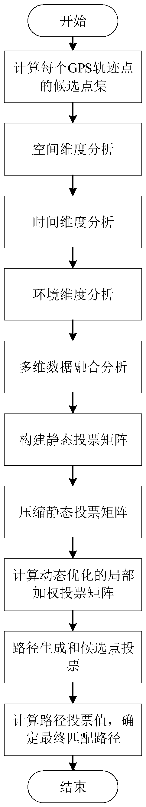
[0081] The technical solution of the present invention will be further described below in conjunction with the accompanying drawings.

[0082] The low-frequency GPS track road network matching method based on multidimensional data fusion analysis of the present invention, the specific implementation steps are as follows:

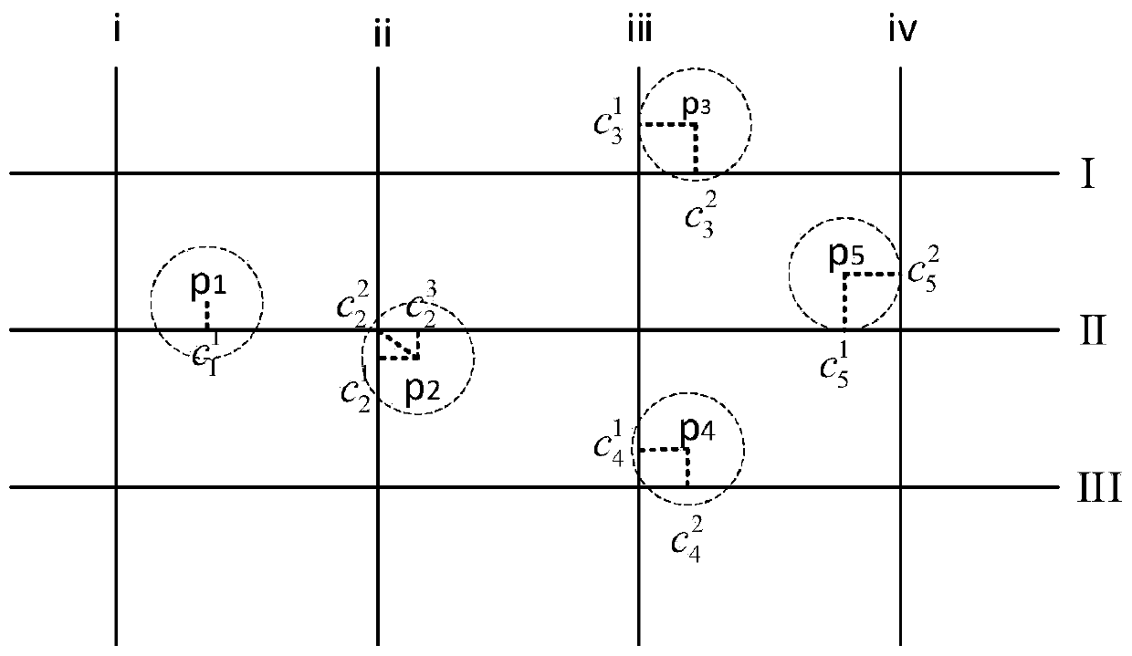
[0083] (1) Calculate the candidate point set for each GPS track point. According to the road network data, the candidate point set corresponding to each track point in the GPS track is calculated, and the specific calculation process is as follows:

[0084] s11. Extract GPS track point p in chronological order i , where 1≤i≤n. The GPS track is: p 1 →p 2 →…→p n , where p i is the i-th GPS track point, and n is the total number of GPS track points. GPS track point contains sampling time t i , the latitude coordinate lat i and longitude sit degree lon i and other information, that is, p i =(t i ,lat i ,lon i );

[0085] s12. Search track point p ...


PUM


Abstract

A low-frequency GPS track road network matching method based on multi-dimensional data fusion analysis comprises the steps that firstly, a candidate point set of each GPS track point is calculated, the matching degree of adjacent candidate points is considered from multiple dimensions such as space, time and environment, multi-dimensional data fusion analysis is conducted, and the final matching degree is formed; then, a global static voting matrix is constructed and compressed, low-correlation-degree abnormal track points are removed, meanwhile, factors such as signal timing are comprehensively considered, and a dynamically-optimized local weighted voting matrix is generated; and finally, path generation and candidate point voting are carried out, the candidate path with the highest voting value is selected as a final matching path, and road network matching of the GPS track is completed. The method is suitable for an urban road network, considers the space-time relationship and environmental influence of adjacent track points, carries out multi-dimensional data fusion analysis, eliminates low-correlation abnormal points, and improves the accuracy of road network matching. Meanwhile, dynamic factors such as signal timing and the like are considered, and the road network matching precision is further improved.

Description

technical field [0001] The invention relates to a GPS track road network matching method for intelligent transportation. The GPS track road network matching can not only be used for vehicle navigation, road planning, traffic flow prediction, etc., but also can be used for various location services and mobile social networks. Background technique [0002] In recent years, the development of cloud computing and the Internet of Things has driven the development of the urban Internet of Vehicles. The detection instruments of many networked vehicles generate and upload massive amounts of data in real time, triggering a global wave of research on "data cities". Currently, we are in a transitional stage from traditional information-based transportation to an intelligent and interconnected society. Limited by cost factors, while installing and deploying various advanced detector equipment, it is necessary to be compatible with early data acquisition equipment with low quality, high ...

Claims


Application Information

Patent Timeline
IPC IPC(8): G06K9/62G06N7/00G01S19/42
CPCG01S19/42G06N7/01G06F18/22Y02A90/10
Inventor 刘端阳韩笑李泽葆沈国江杨曦刘志朱李楠阮中远
Owner ZHEJIANG UNIV OF TECH
Why Eureka
Try Eureka