Dual-mode satellite fusion positioning method suitable for ship traffic management system

A technology for ship traffic management and fusion positioning, which is applied in the field of dual-mode satellite fusion positioning, and can solve problems such as inability to guarantee optimality and inability to obtain positioning results.

Active Publication Date: 2020-07-10
中船鹏力(南京)大气海洋信息系统有限公司 +1
View PDF1 Cites 6 Cited by
  • Summary
  • Abstract
  • Description
  • Claims
  • Application Information

AI Technical Summary

Problems solved by technology

In this case, the least squares method commonly used before cannot guarantee its optimality, and cannot obtain the optimal positioning result, which requires the weighted least squares method to improve the positioning accuracy

Method used


Image

  • Dual-mode satellite fusion positioning method suitable for ship traffic management system
  • Dual-mode satellite fusion positioning method suitable for ship traffic management system
  • Dual-mode satellite fusion positioning method suitable for ship traffic management system

Examples


Embodiment Construction

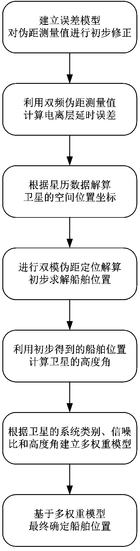
[0053] The present invention will be further described in detail below in conjunction with the accompanying drawings and specific preferred embodiments.

[0054] In the description of the present invention, it should be understood that the orientations or positional relationships indicated by the terms "left side", "right side", "upper", "lower" are based on the orientations or positional relationships shown in the accompanying drawings, and are only For the purpose of describing the present invention and simplifying the description, rather than indicating or implying that the device or element referred to must have a specific orientation, be constructed and operate in a specific orientation, "first", "second" and the like do not represent components importance, and therefore should not be construed as limiting the invention. The specific dimensions used in this embodiment are only for illustrating the technical solution, and do not limit the protection scope of the present in...


PUM


Abstract

The invention discloses a dual-mode satellite fusion positioning method suitable for a ship traffic management system. Dual-mode fusion of Beidou and GPS is performed to realize accurate, real-time and reliable positioning of a ship. The method mainly comprises the following steps: firstly, a satellite dual-frequency pseudo-range error correction model is established; then, spatial position coordinates of a Beidou satellite and a GPS satellite are respectively calculated according to the ephemeris data, and dual-system time-space conversion and unification are carried out; then, Beidou and GPSdual-mode pseudo-range positioning calculation is carried out, and the ship position is preliminarily solved; the elevation angle of each satellite relative to the ship is calculated; then a multi-weight model is established according to factors such as a system category, a signal-to-noise ratio and an elevation angle of the satellite; and finally, positioning calculation is carried out on the ship again based on the multi-weight model, and the spatial position coordinates of the ship at the moment t of the current observation epoch are finally determined. The method is higher in positioningprecision, lower in algorithm complexity and higher in system safety.

Description

technical field [0001] The invention relates to the field of ship navigation and positioning, in particular to a dual-mode satellite fusion positioning method suitable for ship traffic management systems. Background technique [0002] The vigorous development of my country's social economy and the solid advancement of the strategy of "marine power" have driven the year-by-year growth of water transport business volume, and the number of ships has increased sharply. This has also led to a series of problems such as prominent ship traffic pressure, intensified resource consumption, and water environment pollution, posing severe challenges to ship traffic, energy and the environment. In order to effectively solve the above problems, many scholars have embarked on the research of Vessel Traffic Services (VTS), aiming to improve the traffic conditions with the help of advanced navigation and positioning technology, multi-source sensor technology, data communication technology, et...

Claims


Application Information

Patent Timeline
Patent Type & Authority Applications(China)
IPC IPC(8): G01S19/42G01S19/40G01S19/33
CPCG01S19/423G01S19/40G01S19/33
Inventor 夏亮夏金峰金家龙王子骏周晓安盛开
Owner 中船鹏力(南京)大气海洋信息系统有限公司
Why Eureka
Try Eureka