Method for constructing indoor two-dimensional semantic grid map with object navigation point

A grid map and construction method technology, applied in navigation, surveying and navigation, navigation computing tools, etc., can solve the problems that robots cannot truly understand the environment, cannot complete high-level complex tasks, etc., and achieve fast particle convergence and planning efficiency High, stable effect of repositioning process

Active Publication Date: 2020-08-04
WUHAN UNIV OF SCI & TECH
View PDF12 Cites 26 Cited by
  • Summary
  • Abstract
  • Description
  • Claims
  • Application Information

AI Technical Summary

Problems solved by technology

[0002] Although the traditional slam method can meet the needs of robot positioning, mapping, and navigation, the output topological map or raster map can only express the topological and geometric information in the environment. The extraction and description of environmental semantic information makes the robot unable to truly understand the environment and complete high-level complex tasks

Method used


Image

  • Method for constructing indoor two-dimensional semantic grid map with object navigation point
  • Method for constructing indoor two-dimensional semantic grid map with object navigation point
  • Method for constructing indoor two-dimensional semantic grid map with object navigation point

Examples


Embodiment Construction

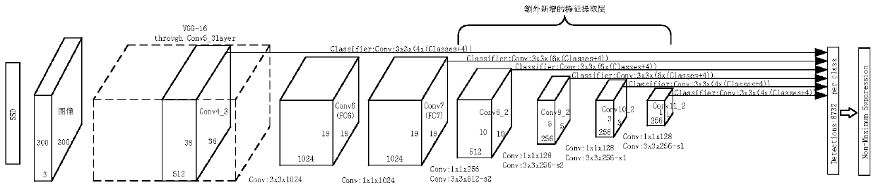
[0058] The technical solutions of the present invention will be further specifically described below through the embodiments and in conjunction with the accompanying drawings, a method for constructing an indoor two-dimensional semantic grid map with object navigation points. The color image and depth image data obtained by Kinect v2, input the color image into the SSD detection and recognition method, obtain the object detection frame and category in the image, and use the registration data to calculate the corresponding position of the object in the color image in the depth image , convert the acquired Kinect v2 depth data into imitation laser data, and convert the imitation laser data with semantic information under the camera to the global map coordinate system, and update each grid cell in the semantic grid map through Bayesian estimation the category status, and finally complete the creation of the semantic grid map. After the map is created, the navigation points are ex...


PUM


Abstract

The invention provides a method for constructing an indoor two-dimensional semantic grid map with an object navigation point. The method comprises the following steps of S1, constructing an environment grid map, and acquiring a real-time position of a robot; S2, completing recognition of an object in an environment; S3, obtaining a main body part of the target object, and obtaining coordinates ofthe target object in a camera coordinate system; S4, performing coordinate conversion to obtain the coordinates of the recognized object in a grid map coordinate system, and establishing an object grid map; S5, combining the object grid map and the environment grid map to obtain a semantic grid map reflecting environment semantic information; and S6, extracting a navigation point of the target object in the semantic grid map to obtain an indoor two-dimensional semantic grid map with the navigation point. According to the method, an original grid map contains semantic information and also contains the object navigation point, the semantic grid map provides richer features for robot positioning and navigation, and higher-level complex tasks can be completed.

Description

technical field [0001] The invention belongs to the field of mobile robot positioning and navigation, in particular to an indoor two-dimensional semantic grid map construction method with object navigation points. Background technique [0002] Although the traditional slam method can meet the needs of robot positioning, mapping, and navigation, the topological map or grid map it outputs can only express topological information and geometric information in the environment. The extraction and description of environmental semantic information makes robots unable to truly understand the environment and to complete high-level complex tasks. In the process of intelligent development of robots, deep learning methods have become an indispensable tool for robots. Object recognition and detection can provide robots with more accurate and stable semantic information, so that robots can think about the environment like humans, understand the environment, and supplement grid maps. The i...

Claims


Application Information

Patent Timeline
Patent Type & Authority Applications(China)
IPC IPC(8): G01C21/32G01C21/20
CPCG01C21/206G01C21/32
Inventor 蒋林聂文康向超马先重朱建阳雷斌
Owner WUHAN UNIV OF SCI & TECH
Why Eureka
Try Eureka