Urban inland inundation risk rapid assessment method and system

A technology for urban waterlogging and risk, applied in the fields of instruments, character and pattern recognition, data processing applications, etc., can solve the problems of high modeling ability requirements, poor practicability, and low computing efficiency.

Active Publication Date: 2020-08-07
SUN YAT SEN UNIV
View PDF5 Cites 6 Cited by
  • Summary
  • Abstract
  • Description
  • Claims
  • Application Information

AI Technical Summary

Problems solved by technology

[0003] The present invention provides a method and system for rapid urban waterlogging risk assessment to solve the problems that the existing waterlogging risk assessment has high requirements for basic data and modeling capabilities of operators, and has low calculation efficiency and poor practicability

Method used


Image

  • Urban inland inundation risk rapid assessment method and system
  • Urban inland inundation risk rapid assessment method and system
  • Urban inland inundation risk rapid assessment method and system

Examples


Embodiment 1

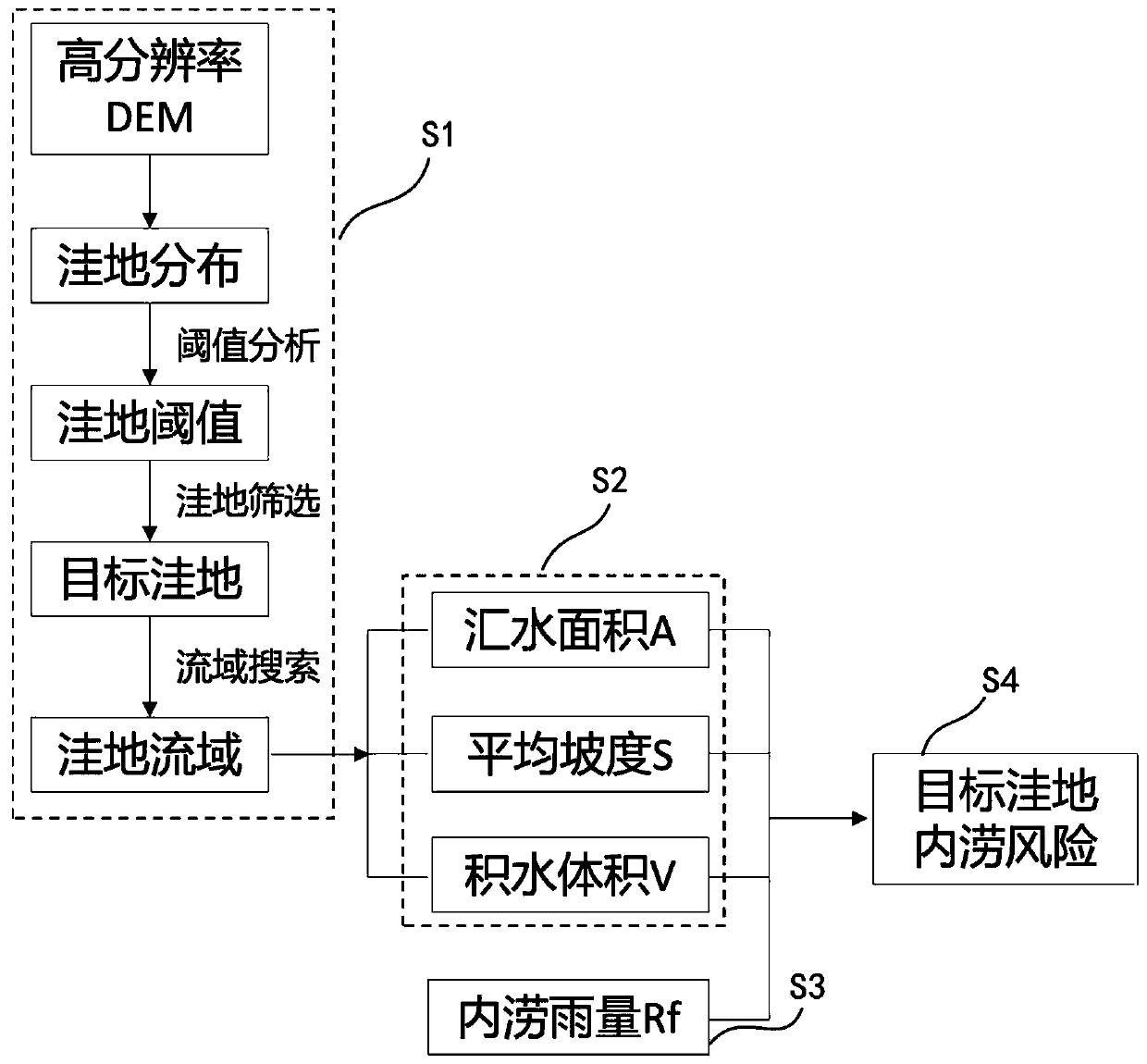
[0054] This embodiment provides a method for rapid assessment of urban waterlogging risk, such as figure 1 and 2 shown, including the following steps:

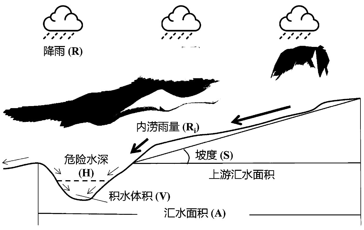
[0055] S1. For the target area, identify the potential location of waterlogging according to DEM, delineate the catchment range of each location where waterlogging occurs, and form the corresponding small watershed; since this step is based on DEM, the spatial resolution of DEM and the elevation accuracy It is very important for the rationality of the waterlogging risk assessment results, and the high-precision and high-resolution DEM produced by lidar technology should be used as much as possible when conditions permit. When choosing the spatial resolution of DEM, it is necessary to achieve a certain balance between the accuracy of micro-topography expression (the higher the resolution, the higher the accuracy) and the calculation efficiency (the lower the resolution, the higher the efficiency).

[0056] The specific steps ...

Embodiment 2

[0080] In order to verify the effectiveness of the rapid assessment method of urban waterlogging risk in the above-mentioned embodiment 1, the following example analysis of waterlogging risk was carried out:

[0081] This example analysis is based on a certain area in Guangzhou City, with an area of ​​about 20 square kilometers, an impervious rate of 73%, and a design drainage capacity that can cope with a one-year return period of heavy rain. This example analyzes the waterlogging risk in this area under the 5-year return period rainfall scenario. The specific steps and results are explained as follows:

[0082] (1) Using airborne lidar technology to produce a 1-meter-resolution DEM, set the area threshold of this example to 5000 square meters after depression identification and threshold analysis, and 53 depressions were retained after screening;

[0083] (2) Use the watershed search method to determine the catchment range of each depression, which forms a small watershed wi...

Embodiment 3

[0092] This embodiment provides a rapid urban waterlogging risk assessment system, such as Figure 7 shown, including:

[0093] Small watershed building block 1, which is used to identify potential waterlogging occurrence locations in the target area based on DEM, delineate the water catchment range of each waterlogging occurrence location, and form corresponding small watersheds;

[0094] The small watershed attribute calculation module 2 is used to calculate the attributes of each small watershed, including its catchment area A, average slope S, and water volume V;

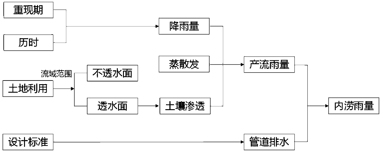
[0095] The waterlogging rainfall calculation module 3 is used to set the rainfall scenario. According to the water balance model, considering the impact of drainage system design standards, soil infiltration and evapotranspiration, calculate the waterlogging rainfall R that forms ponding on the surface i ;

[0096] The waterlogging risk assessment module 4 is used to use the small watershed obtained by the sma...


PUM


Abstract

The invention discloses an urban inland inundation risk rapid assessment method and system, and the method and system take the inland inundation occurrence speed as a risk measurement standard: for agiven inland inundation point, the shorter the time needed for reaching a dangerous ponding depth after rainfall is, the more limited the time reserved for emergency response is, and the higher the corresponding risk is. According to the scheme, calculation can be conducted only by designing rainstorm, DEM, land utilization / coverage and drainage system design standards, a complex hydrodynamic model is not involved, the requirement for drainage pipe network data is low, and calculation can be completed based on a GIS platform. According to the method and the system, the problems of high requirements on basic data and modeling capability of operators, low calculation efficiency and poor practicability of existing inland inundation risk assessment are solved.

Description

technical field [0001] The invention relates to the technical field of waterlogging disaster risk assessment, in particular to a method and system for rapid urban waterlogging risk assessment. Background technique [0002] Under the background of global warming and urbanization, the comprehensive effect of hydrological effects such as the "rain island effect" in urban areas, the increase of runoff and the acceleration of confluence make the pressure and risk of urban waterlogging on the whole increase, which needs to be solved through the construction of sponge cities. To mitigate the waterlogging risk, its mitigation effect depends on the accurate understanding and assessment of the actual waterlogging risk. Existing waterlogging risk assessment mostly adopts hydrodynamic waterlogging simulation based on "rainfall-production and confluence-pipeline drainage-surface overflow". This type of method has high requirements for basic data, high requirements for operators' modeling...

Claims


Application Information

Patent Timeline
Patent Type & Authority Applications(China)
IPC IPC(8): G06K9/62G06Q10/06G06Q50/26
CPCG06Q10/0635G06Q50/26G06F18/24Y02A10/40
Inventor 黄华兵王先伟
Owner SUN YAT SEN UNIV
Why Eureka
Try Eureka