Supercharge Your Innovation With Domain-Expert AI Agents!

Navigation method and system based on gravity difference information of adjacent survey lines

A navigation method and an inertial navigation system technology, which are applied in the field of navigation methods and systems based on the gravity difference information of adjacent survey lines, can solve the problems of poor safety and concealment of navigation technology, and reduce the safety and concealment of submarines. Achieve the effect of facilitating accurate matching, improving concealment and security, and weakening system errors

Active Publication Date: 2020-08-14
中国人民解放军61540部队 +1
View PDF5 Cites 3 Cited by
  • Summary
  • Abstract
  • Description
  • Claims
  • Application Information

AI Technical Summary

Problems solved by technology

Then, other non-gravity navigation methods can only be used in areas with inconspicuous features, such as satellite navigation (need to float to the sea surface), sonar navigation (need to send sonar, easy to be intercepted), astronomical navigation (need to float to the sea surface), geomagnetic navigation ( Susceptible to the submarine's own magnetic interference), etc., these navigation technologies are not safe and concealed
Reduced the safety and concealment of submarines

Method used


Image

  • Navigation method and system based on gravity difference information of adjacent survey lines
  • Navigation method and system based on gravity difference information of adjacent survey lines
  • Navigation method and system based on gravity difference information of adjacent survey lines

Examples


Embodiment Construction

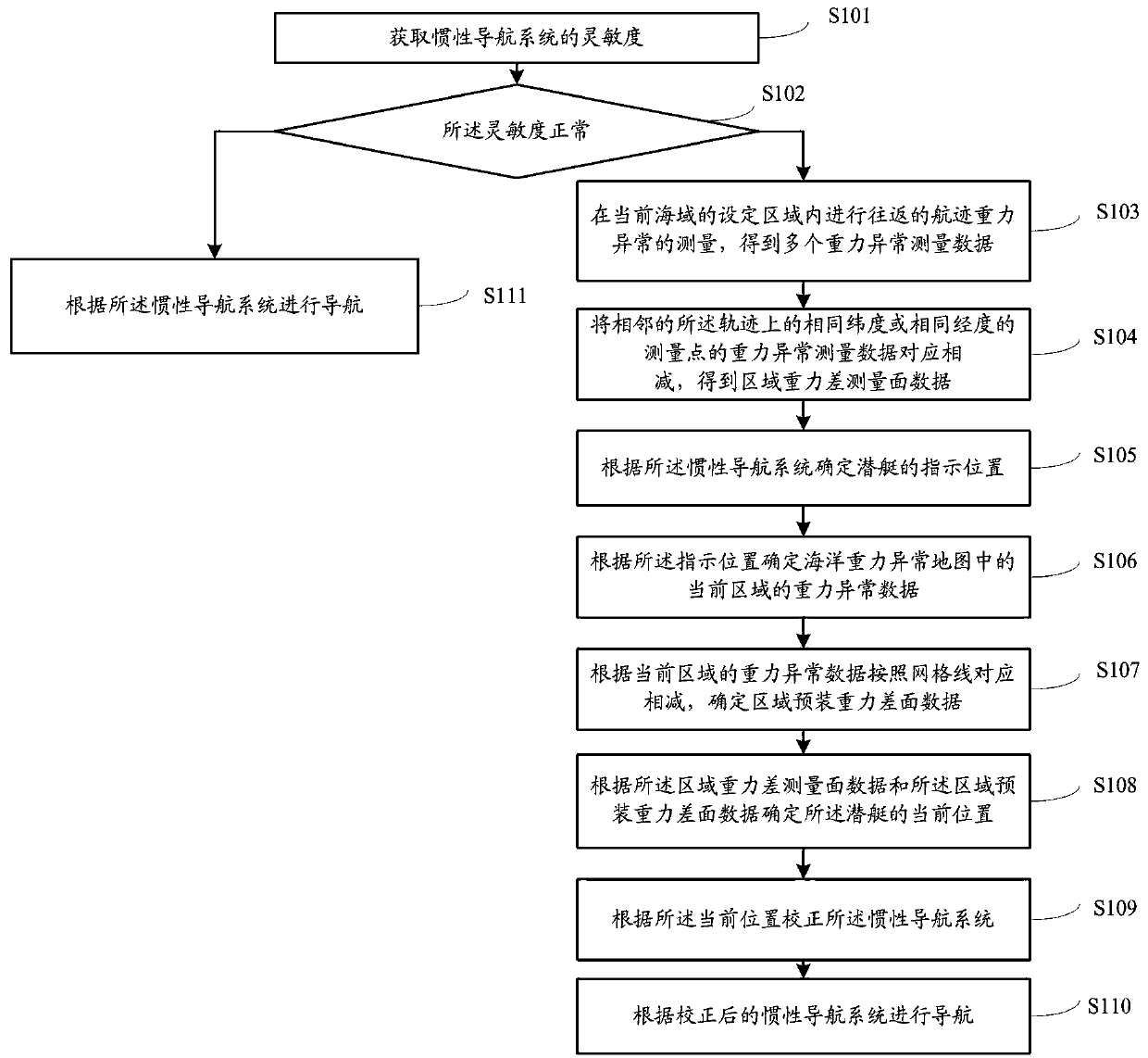
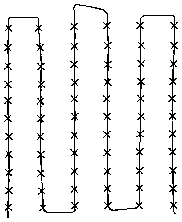
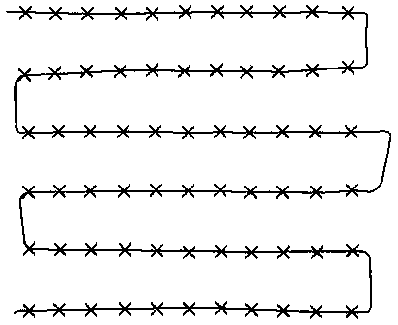
[0068] The following will clearly and completely describe the technical solutions in the embodiments of the present invention with reference to the accompanying drawings in the embodiments of the present invention. Obviously, the described embodiments are only some, not all, embodiments of the present invention. Based on the embodiments of the present invention, all other embodiments obtained by persons of ordinary skill in the art without making creative efforts belong to the protection scope of the present invention.

[0069] The purpose of the present invention is to provide a navigation method and system based on the gravity difference information of adjacent measuring lines, so as to improve the safety and concealment of the submarine.

[0070] In order to make the above objects, features and advantages of the present invention more comprehensible, the present invention will be further described in detail below in conjunction with the accompanying drawings and specific emb...


PUM


Abstract

The invention relates to a navigation method and system based on gravity difference information of adjacent survey lines. The method comprises the steps of when the sensitivity of an inertial navigation system is abnormal, conducting round-trip track gravity anomaly measurement in a set area of a current sea area to obtain multiple pieces of gravity anomaly measurement data; correspondingly subtracting the gravity anomaly measurement data of the measurement points with the same latitude or longitude on the adjacent tracks to obtain regional gravity difference measurement surface data; correspondingly subtracting according to grid lines according to the gravity anomaly data of the current area to determine area pre-installed gravity difference surface data; determining the current positionof a submarine according to the regional gravity difference measurement surface data and the regional pre-installed gravity difference surface data; correcting the inertial navigation system accordingto the current position; and performing navigation according to the corrected inertial navigation system. According to the navigation method and system based on the gravity difference information ofthe adjacent survey lines, the safety and concealment of the submarine are improved.

Description

technical field [0001] The invention relates to the field of gravity navigation of underwater submersibles, in particular to a navigation method and system based on gravity difference information of adjacent measuring lines. Background technique [0002] The traditional gravity matching assisted navigation, the matching base map is the global ocean gravity anomaly, some regional changes are obviously conducive to matching, and some regional changes are gentle, and there are no obvious features for matching. Therefore, in order to clearly obtain the easy-to-match areas, the areas with obvious features were screened out to construct the gravity lighthouse database. Then, other non-gravity navigation methods can only be used in areas with inconspicuous features, such as satellite navigation (need to float to the sea surface), sonar navigation (need to send sonar, easy to be intercepted), astronomical navigation (need to float to the sea surface), geomagnetic navigation ( Susce...

Claims


Application Information

Patent Timeline
IPC IPC(8): G01C21/16G01C21/00
CPCG01C21/005G01C21/165
Inventor 肖云任飞龙刘晓刚
Owner 中国人民解放军61540部队
Features
  • R&D
  • Intellectual Property
  • Life Sciences
  • Materials
  • Tech Scout
  • Unparalleled Data Quality
  • Higher Quality Content
  • 60% Fewer Hallucinations
Learn More