Meta-grid generation method and device based on geographic information

A grid generation and geographic information technology, applied in the field of geographic information systems, can solve problems such as inconsistency and lack of a unified drawing reference

Active Publication Date: 2020-08-18
CHINA ENERGY ENG GRP GUANGDONG ELECTRIC POWER DESIGN INST CO LTD
View PDF4 Cites 15 Cited by
  • Summary
  • Abstract
  • Description
  • Claims
  • Application Information

AI Technical Summary

Problems solved by technology

[0006] The purpose of the present invention is to use the meta-grid as the basis of all grids, and when drawing grids for each business type, they can be constructed uniformly based on the existing meta-grids through aggregation, fundamentally solving the lack of a unified drawing benchmark and thus The size, shape, and position of the two drawing of the same business type grid are inconsistent before and after

Method used


Image

  • Meta-grid generation method and device based on geographic information
  • Meta-grid generation method and device based on geographic information
  • Meta-grid generation method and device based on geographic information

Examples


no. 1 example

[0045] see figure 1 -9.

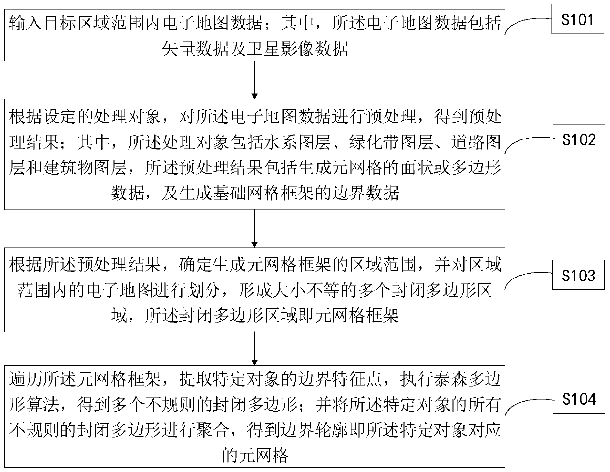
[0046] Such as figure 1 As shown, this embodiment provides a meta-grid generation method based on geographic information, which is suitable for execution in computer equipment, and at least includes the following steps:

[0047] S101. Input electronic map data within the scope of the target area; wherein, the electronic map data includes vector data and satellite image data;

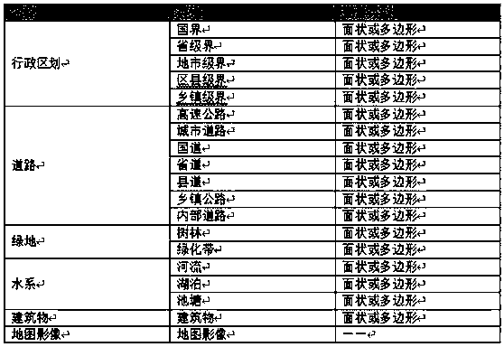
[0048] S102. Perform preprocessing on the electronic map data according to the set processing object to obtain a preprocessing result; wherein, the processing object includes a water system layer, a green belt layer, a road layer, and a building layer, so The above preprocessing results include generating surface or polygon data of the meta-grid, and generating boundary data of the basic grid framework;

[0049] S103. According to the preprocessing result, determine the area range for generating the meta-grid framework, and divide the electronic map within the area range to f...

no. 2 example

[0115] see Figure 10 .

[0116] Such as Figure 10 As shown, this embodiment also provides a meta-grid generation device based on geographic information, including:

[0117] The electronic data preprocessing module 201 is used to perform preprocessing operations on electronic map data to obtain preprocessing results; wherein, the processing objects include water system layers, green belt layers, road layers and building layers, and the preprocessing The processing results include generating the surface or polygon data of the meta-grid, and generating the boundary data of the basic grid frame;

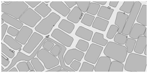
[0118] The meta-grid frame building module 202 is used to determine the area range for generating the meta-grid frame according to the preprocessing results, and divide the electronic map within the area range to form a plurality of closed polygonal areas of different sizes. The enclosed polygonal area is the meta-grid framework;

[0119] The meta-grid generation module 203 is used...


PUM


Abstract

The invention discloses a meta-grid generation method and device based on geographic information. The meta-grid generation method comprises the following steps: inputting electronic map data in a target area range; preprocessing the electronic map data according to a set processing object to obtain a preprocessing result; determining a region range of a generated meta-grid framework according to the preprocessing result; traversing the meta-grid framework, extracting boundary feature points of a specific object, and executing a Thiessen polygon algorithm to obtain a plurality of irregular closed polygons; and aggregating all irregular closed polygons of the specific object to obtain a boundary contour, namely a meta-grid corresponding to the specific object. According to the meta-grid generation method, the meta-grids can serve as the basis of all the grids, and all the service types can be constructed in a unified mode based on the existing meta-grids in an aggregation mode when the grids are drawn, and the problems that the sizes, shapes and positions of the grids of the same service type are inconsistent after and after two times of drawing due to lack of a unified drawing benchmark are fundamentally solved.

Description

technical field [0001] The invention relates to the technical field of geographic information systems, in particular to a method and device for generating meta-grids based on geographic information. Background technique [0002] At present, with the rapid development of various GIS (Geographic Information System, Geographic Information System) software, the demand for GIS software from all walks of life is becoming more and more diversified. In addition to obtaining simple geographic information through GIS, there are more and more application analysis of business scenarios based on geographic information. In order to carry out spatial display analysis based on geographic information more accurately, various businesses generally adopt the method of splitting large-scale geographic spatial analysis into multiple analysis in specific spatial regions. Therefore, drawing the corresponding closed polygonal area (namely "grid", hereinafter collectively referred to as "grid") on t...

Claims


Application Information

Patent Timeline
Patent Type & Authority Applications(China)
IPC IPC(8): G06T11/20G06T7/11G06T7/13G06F16/29
CPCG06T11/20G06T7/11G06T7/13G06F16/29G06T2207/20128
Inventor 王海吉裴璐遥解文艳吉小恒陈志坚胡健坤冯国平古明生
Owner CHINA ENERGY ENG GRP GUANGDONG ELECTRIC POWER DESIGN INST CO LTD
Why Eureka
Try Eureka