High-resolution remote sensing image semantic segmentation method sharing multi-scale adversarial features

A remote sensing image and semantic segmentation technology, applied in the field of remote sensing images, can solve the problems of inaccurate boundary semantic recognition, spatial discontinuity, and lack of correlation of boundary pixels, and achieve accurate semantic label prediction map, good spatial continuity and accurate boundary. The effect of good migration and application ability

Active Publication Date: 2020-08-25
CENT SOUTH UNIV
View PDF7 Cites 8 Cited by
  • Summary
  • Abstract
  • Description
  • Claims
  • Application Information

AI Technical Summary

Problems solved by technology

[0005] The purpose of the present invention is to provide a high-resolution remote sensing image semantic segmentation method that shares multi-scale confrontation features to solve the problem of spatial discontinuity in the recognition of similar features in remote sensing images in the background technology, and the lack of correlation between boundary pixels between different feature categories The problem of inaccurate identification of gender and boundary semantics

Method used


Image

  • High-resolution remote sensing image semantic segmentation method sharing multi-scale adversarial features
  • High-resolution remote sensing image semantic segmentation method sharing multi-scale adversarial features
  • High-resolution remote sensing image semantic segmentation method sharing multi-scale adversarial features

Examples


Embodiment Construction

[0040]The embodiments of the present invention will be described in detail below with reference to the accompanying drawings, but the present invention can be implemented in various ways defined and covered by the claims.

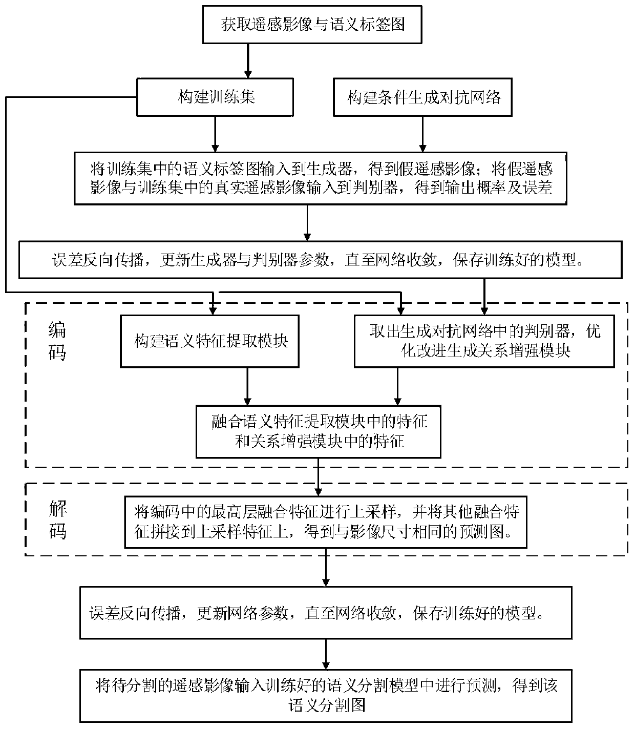
[0041] see Figure 1 to Figure 6 , this embodiment provides a high-resolution remote sensing image semantic segmentation method sharing multi-scale confrontation features, including the following steps:

[0042] S1. Obtain remote sensing images and their semantic label training sets, obtain remote sensing images and corresponding semantic label maps by downloading from the Internet, and cut the acquired remote sensing images and corresponding semantic label maps into 256*256 size images with the same step size Pairs of blocks constitute a remote sensing image and its semantic label training set;

[0043] S2. Using the training set to train the generated confrontation network, including the following steps:

[0044] S2.1. Input the semantic label map in th...


PUM


Abstract

The invention provides a high-resolution remote sensing image semantic segmentation method sharing multi-scale adversarial features, a multi-scale adversarial network model is introduced, and multi-scale detail information of a remote sensing image is well described by using multi-scale structure learning of the adversarial features; meanwhile, a discriminator of the adversarial network model is improved, is used as a relationship enhancement module; the correlation and boundary information of the target ground object are further described; on one hand, correlation between pixels in the same ground object can be expressed, and on the other hand, edge pixels of each image are associated with pixels of other two or more ground object categories around the image, so that better spatial continuity and boundary accuracy of a target ground object are obtained, and the boundary and semantic accuracy of a remote sensing image prediction result is improved; besides, the adversarial features ofthe method can be flexibly embedded into different semantic segmentation reference models, have good migration application capability, and can correspondingly improve the performance.

Description

technical field [0001] The invention relates to the field of remote sensing images, and more specifically, to a high-resolution remote sensing image semantic segmentation method sharing multi-scale confrontation features. Background technique [0002] With the development of earth observation technology, high-resolution remote sensing images (HRSIs) have attracted extensive attention in remote sensing research and applications. The semantic segmentation of HRSI aims to assign a geographic object category to each pixel of the ground object and have a precise boundary between geographic objects. It is the primary task of remote sensing image analysis and understanding, and plays an important role in a wide range of applications such as urban planning, disaster monitoring, and precision agriculture. Deep convolutional neural networks (DCNNs) have achieved success in the field of computer vision due to their powerful feature representation capabilities, and have been widely use...

Claims


Application Information

Patent Timeline
Patent Type & Authority Applications(China)
IPC IPC(8): G06K9/00G06K9/34G06K9/62
CPCG06V20/13G06V10/267G06F18/2193G06F18/2415G06F18/253G06F18/214
Inventor 陈杰朱晶茹万里周兴何玢邓敏
Owner CENT SOUTH UNIV
Why Eureka
Try Eureka