Remote sensing detection method based on UAV platform
A detection method and unmanned aerial vehicle technology, applied in the field of remote sensing and surveying and mapping, can solve the problems of multi-source heterogeneity that cannot be effectively integrated, and achieve the effect of integrated detection and resolution of differences in spatial location and scale
- Summary
- Abstract
- Description
- Claims
- Application Information
AI Technical Summary
Problems solved by technology
Method used
Image
Examples
specific Embodiment approach 1
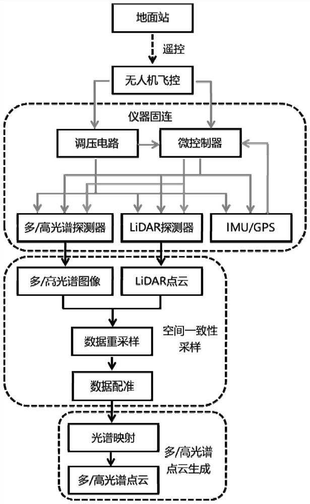
[0084] Specific implementation mode 1. Combination figure 1 As shown, the present invention provides a remote sensing detection method based on an unmanned aerial vehicle platform, realized based on a spectral detector and a LiDAR detector, and the spectral detector is a multi / hyperspectral detector; comprising:
[0085] Step 1: Mount the spectrum detector and LiDAR detector as a whole frame under the UAV, and provide the working voltage through the voltage output interface reserved by the UAV flight controller;
[0086] Step 2: Use the UAV ground station to control the UAV flight controller to send data acquisition commands to the microcontroller, and the microcontroller performs synchronous acquisition and control of the spectrum detector, LiDAR detector and IMU / GPS integrated navigation unit; and The collected spectral image data and LiDAR point cloud data are registered for data registration to obtain the spatial correspondence between the two data; at the same time, the s...
PUM
 Abstract
Description
Claims
Application Information
 - R&D
- Intellectual Property
- Life Sciences
- Materials
- Tech Scout
- Unparalleled Data Quality
- Higher Quality Content
- 60% Fewer Hallucinations
Browse by: Latest US Patents, China's latest patents, Technical Efficacy Thesaurus, Application Domain, Technology Topic, Popular Technical Reports.
© 2025 PatSnap. All rights reserved.Legal|Privacy policy|Modern Slavery Act Transparency Statement|Sitemap|About US| Contact US: help@patsnap.com


