Composite terrain feature simulation method and device and electronic device

A technology of terrain features and geological features, applied in the field of radar, can solve the problem of single clutter simulated terrain environment

Pending Publication Date: 2020-09-11
北京华力创通科技股份有限公司
View PDF7 Cites 0 Cited by
  • Summary
  • Abstract
  • Description
  • Claims
  • Application Information

AI Technical Summary

Problems solved by technology

[0006] The purpose of the embodiments of the present application is to provide a method, device and electronic equipment for simulating complex terrain features, so as to improve the single terrain environment of clutter simulation in the prior art due to the lack of complex terrain features required for clutter simulation. question

Method used


Image

  • Composite terrain feature simulation method and device and electronic device
  • Composite terrain feature simulation method and device and electronic device
  • Composite terrain feature simulation method and device and electronic device

Examples


Embodiment Construction

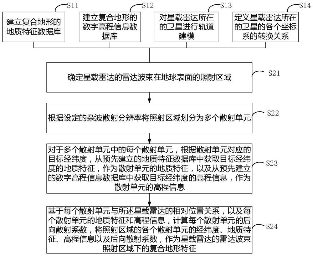
[0057] The technical solutions in the embodiments of the present application will be described below with reference to the drawings in the embodiments of the present application.

[0058] The inventors have found through research that although some current clutter environment modeling methods solve some problems in the research and verification of radar anti-clutter algorithms, the simulated clutter scenes are limited, which has great restrictions on practical applications.

[0059] For example, a clutter environment modeling method based on statistical characteristics in the prior art is to model the clutter environment by fitting the statistical characteristics of clutter under typical landform characteristics based on the measured data under the ground and airborne platforms , because this method is based on the data of the ground-based and airborne platform for fitting modeling, it is separated from the spaceborne platform and the actual terrain environment, and is not suit...


PUM


Abstract

The embodiment of the invention provides a composite terrain feature simulation method and device and an electronic device, and the method comprises the steps: building a geological feature database and a digital elevation information database of a composite terrain, carrying out the orbit modeling of a satellite where a satellite-borne radar is located, and determining the conversion relation ofall coordinate systems of the satellite; determining an irradiation area of a radar beam of the satellite-borne early warning radar on the surface of the earth; and dividing an irradiation area according to the clutter scattering resolution to obtain a scattering unit; according to the target longitude and latitude corresponding to the scattering unit, obtaining geologic characteristics and elevation information of the scattering unit from a geologic characteristic database and a digital elevation information database respectively; and based on the geological characteristics and the elevationinformation of each scattering unit and the relative position relationship between each scattering unit and the radar, calculating the backward scattering coefficient of each scattering unit by adopting a calculation model, and taking the longitude and latitude, the geological characteristics, the elevation information and the backward scattering coefficient of each scattering unit as the composite terrain characteristics under the irradiation area.

Description

technical field [0001] The present application relates to the field of radar technology, in particular, to a method, device and electronic equipment for simulating complex terrain features. Background technique [0002] Spaceborne early warning radar is a kind of spaceborne radar, which has become the focus of national defense attention and research in recent years. Since the orbital height of the satellite platform carried by the space-borne early warning radar is much higher than that of any aircraft, the space-borne early warning radar can observe a very wide range of ground, and can simultaneously monitor ground targets within thousands of kilometers. , The ability of surface targets. [0003] However, since space-borne radars (including space-borne early warning radars) perform long-distance detection at high altitudes, the search area is wide, and the satellites carried are moving at high speeds, the ground-sea clutter faced by the radars is not only strong, but also ...

Claims


Application Information

Patent Timeline
Patent Type & Authority Applications(China)
IPC IPC(8): G01S7/40
CPCG01S7/4052G01S7/4082
Inventor 刘敏鲁旭东
Owner 北京华力创通科技股份有限公司
Why Eureka
Try Eureka