Path planning method based on congestion level prediction analysis

A predictive analysis and route planning technology, applied in the field of intelligent transportation, can solve problems such as algorithm complexity and incomplete influencing factors, and achieve the effects of alleviating traffic congestion, wide prediction range and reducing complexity

Active Publication Date: 2020-09-22
XIDIAN UNIV
View PDF12 Cites 0 Cited by
  • Summary
  • Abstract
  • Description
  • Claims
  • Application Information

AI Technical Summary

Problems solved by technology

However, among the above two predictive route planning methods, the former requires a lot of calculations to determine the predictive model, and the factors considered are not comprehensive enough. algorithm complexity

Method used


Image

  • Path planning method based on congestion level prediction analysis
  • Path planning method based on congestion level prediction analysis
  • Path planning method based on congestion level prediction analysis

Examples


Embodiment Construction

[0029] Below in conjunction with accompanying drawing and embodiment, the present invention is described in further detail:

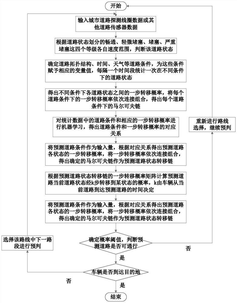
[0030] refer to figure 1 , the present invention comprises the following steps:

[0031] Step 1, acquire urban road detection coil data or other road sensor data.

[0032] Urban road detection coils are usually located around the road or buried under the road, and can calculate the speed of the vehicle by sensing the arrival and departure of the vehicle; other road sensors include road cameras, ultrasonic sensors, and geomagnetic sensors, which can easily obtain the vehicle's driving speed speed;

[0033] The average speed of the road can be obtained by averaging the speeds of all vehicles obtained at a certain moment, and this data can be directly provided by detection coils or road sensors.

[0034] Step 2. Judging the current road state according to the average road speed data provided by the detection coil and the respective speed ranges of the f...


PUM


Abstract

The invention provides a path planning method based on congestion level prediction analysis, and mainly solves the problems of large demand for real-time data and complex prediction in the prior art.According to the scheme, the method comprises the steps of judging the state of a certain road according to the average speed of the road and divided road grade, and counting different road conditionsand corresponding road states by integrating factors such as a road topological structure, time and weather; analyzing the statistical data to obtain one-step transition probabilities of the road states under different conditions, and establishing a corresponding relationship between the one-step transition probabilities and the road conditions; obtaining a predicted road state transition chain according to the corresponding relationship and the current road condition of the predicted road; according to a one-step transition probability matrix of the chain, obtaining the probability of transition of the predicted road from the current state to a certain state, and according to the comparison of the probability and a probability threshold, judging whether the road is passable or not. According to the method, the demand for real-time traffic data is reduced, the prediction complexity is reduced, and the method can be used for traffic path selection during vehicle travel in an urban roadnetwork.

Description

technical field [0001] The invention belongs to the technical field of intelligent transportation, and in particular relates to a route planning method, which can be used for the passage route selection when vehicles travel in an urban road network. Background technique [0002] Urban traffic is the top priority of urban life and an important symbol to measure urban civilization. With the rapid development of social economy and the rapid growth of urban traffic demand, the traffic problem has become an urgent problem to be solved in the process of urban development. As the most significant manifestation of traffic problems, traffic congestion directly leads to serious problems such as traffic accidents, wasted driving time, rising operating costs, and air pollution. This also makes traffic congestion the key to restricting urban economic and social development. [0003] In recent years, urban road congestion has become more and more serious, directly affecting the overall o...

Claims


Application Information

Patent Timeline
Patent Type & Authority Applications(China)
IPC IPC(8): G01C21/34
CPCG01C21/3492
Inventor 李长乐张和和岳文伟陈越
Owner XIDIAN UNIV
Why Eureka
Try Eureka