Storage and retrieval method and system for large-scale geographic space data

A geospatial data, large-scale technology, applied in the field of geographic information, can solve the problem of lack of efficient storage and retrieval solutions for geospatial data

Active Publication Date: 2020-10-16
中国科学院电子学研究所苏州研究院
View PDF10 Cites 11 Cited by
  • Summary
  • Abstract
  • Description
  • Claims
  • Application Information

AI Technical Summary

Problems solved by technology

[0004] To sum up, there is currently a lack of research on efficient storage and retrieval solutions for geospatial data in related fields to

Method used


Image

  • Storage and retrieval method and system for large-scale geographic space data
  • Storage and retrieval method and system for large-scale geographic space data
  • Storage and retrieval method and system for large-scale geographic space data

Examples


Embodiment Construction

[0059] In order to make the purpose, technical solutions, and advantages of this application clearer, the following further describes this application in detail with reference to the accompanying drawings and embodiments. It should be understood that the specific embodiments described here are only used to explain the application, and not used to limit the application.

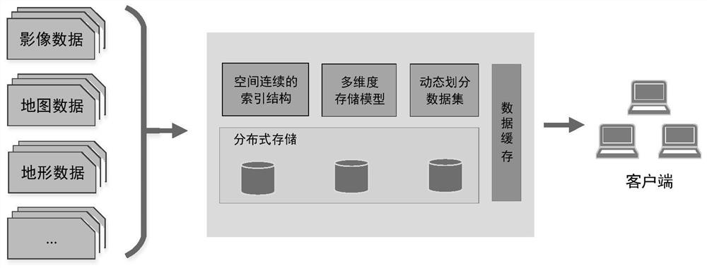
[0060] The present invention is a method for storing and retrieving large-scale geospatial data. By defining spatially continuous tile codes, a multi-dimensional storage model covering attributes such as space, time, feature elements, geographic scenes, etc. is generated; by supporting dynamically divided data sets Retrieval method to realize efficient storage and query of geospatial data, such as figure 1 As shown, the specific steps are as follows:

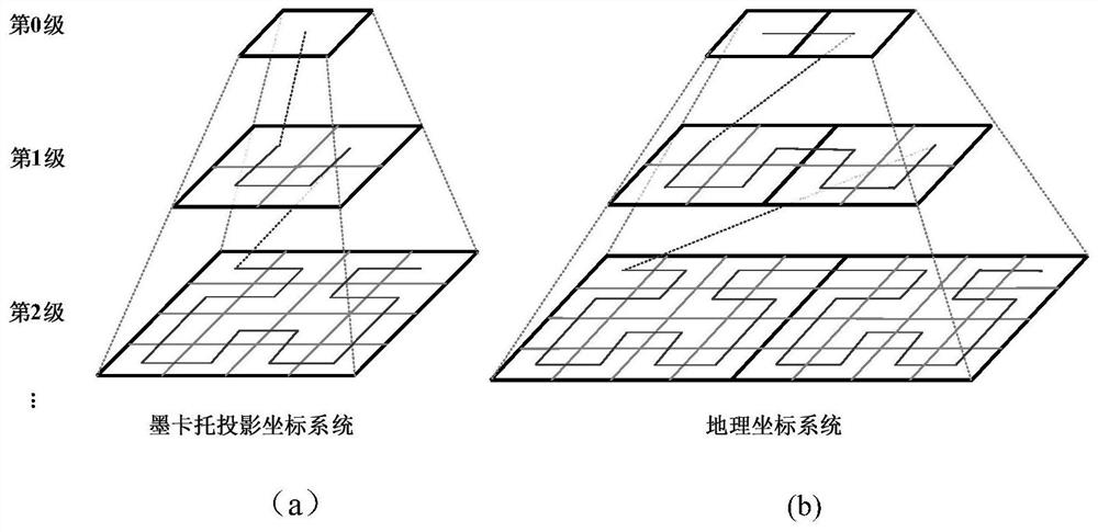
[0061] Step 1. Construct a spatially continuous index coding structure

[0062] Based on the idea of ​​space filling curve, a continuous space filling curve is used ...


PUM


Abstract

The invention provides a storage and retrieval method and system for large-scale geographic space data. The method comprises the following steps: mapping geographic space data to a tile pyramid model,filling a tile pyramid by using a space filling curve, and carrying out coded expression on tile nodes on the space filling curve to construct a space continuous index coding structure; constructinga multi-dimensional structured storage model which comprises a tile data table and a secondary index table, storing geographic space tile data, basic information of the geographic space tile data andtile data keys into the tile data table, and storing tile index keys and tile index values into the secondary index table; and generating a data query filter for data set retrieval according to the retrieval conditions of the data and the correlation between each dimension and the data storage structure. The multi-dimensional retrieval method and the quick query process of the geographic space data are realized, the access frequency of the database is reduced, and the access speed of the data is increased.

Description

Technical field [0001] The invention relates to geographic information technology, in particular to a method and system for storing and retrieving large-scale geographic spatial data. Background technique [0002] Geospatial data is difficult to perform unified data processing and analysis due to its inherent characteristics of massive, multi-source, and heterogeneous. Therefore, the establishment of a standardized organization model based on a unified time-space reference is an effective plan for standardized organization of multi-source geospatial data in the current geographic information system. [0003] The mainstream organization model relies on the spatial location of the data to divide the data into a spatial grid, and establish a pyramid data model with a uniform size from low to high data resolution and from small to large data volume. On this basis, through data cutting, mosaic and resampling, the standardized reorganization of data is realized, and the data retrieval f...

Claims


Application Information

Patent Timeline
IPC IPC(8): G06F16/29G06F16/2455G06F16/22
CPCG06F16/2228G06F16/2455G06F16/29
Inventor 朱利鲁苏晓露高瞻王马鑫阎克栋
Owner 中国科学院电子学研究所苏州研究院
Why Eureka
Try Eureka