Three-dimensional geographic information model space analysis method and system based on rules

A technology of model space and geographic information, applied in the field of spatial analysis, can solve the problems of reducing the efficiency of big data analysis in TOD cities, the inability to analyze multi-dimensional space, and the lack of spatial analysis functions in 3D geographic information systems, so as to achieve rapid and accurate monitoring and analysis and improve efficiency Effect

Active Publication Date: 2020-10-16
CHINA ACAD OF URBAN PLANNING & DESIGN
View PDF10 Cites 4 Cited by
  • Summary
  • Abstract
  • Description
  • Claims
  • Application Information

AI Technical Summary

Problems solved by technology

[0005] In view of the above problems, the purpose of the present invention is to solve the problem that the display of spatial information in the prior art is too abstract, the three-dimensional geographic information system lacks a spatial analysis function, cannot analyze multi-dimensional space, and reduces the analysis efficiency of TOD city big data problem, to realize visual display of spatial information, enhance multi-dimensional spatial analysis, and improve the efficiency of monitoring and analysis of TOD urban big data

Method used


Image

  • Three-dimensional geographic information model space analysis method and system based on rules
  • Three-dimensional geographic information model space analysis method and system based on rules
  • Three-dimensional geographic information model space analysis method and system based on rules

Examples


Embodiment 1

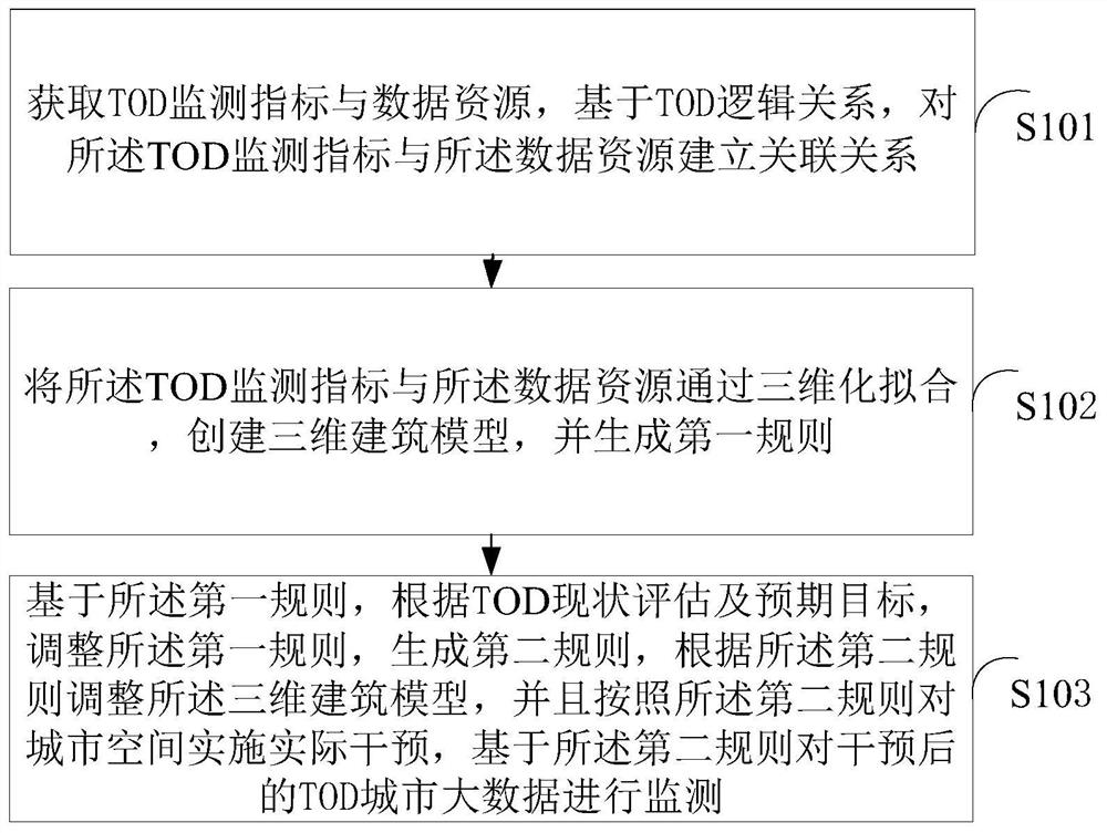
[0091] The existing rail station L4-6 (the 6th station of Line 4) serves residential building A, office building B, shopping mall C and park D around the station. Based on the collected traditional two-dimensional plane data and big data of TOD monitoring indicators, it is established that 2,273 residents belong to residential building A, of which 10% (227) residents travel through rail station L4-6; 3,000 employed people belong to office building B, 30% (900) of employed persons travel through rail station L4-6 and a series of mapping relationships and topological connection relationships.

[0092] Based on the above TOD logical relationship, use 3D rule fitting modeling to generate a large batch of refined 3D city models. Each digital spatial position in the 3D model corresponds to multi-dimensional attribute information and the first rule. For example, residential building A There are 8 households and 26 residents on the 12th floor; the 10th floor of the office building B c...


PUM


Abstract

The invention discloses a three-dimensional geographic information model space analysis method based on rules, and the method comprises the steps: obtaining a TOD monitoring index and a data resource,and establishing an association relation between the TOD monitoring index and the data resource based on a TOD logic relation; performing three-dimensional fitting on the TOD monitoring indexes and the data resources, creating a three-dimensional building model, and generating a first rule; based on the first rule, and according to TOD current situation evaluation and an expected target, adjusting the first rule, generating a second rule, adjusting the three-dimensional building model according to the second rule, implementing actual intervention on the urban space according to the second rule, and monitoring the intervened TOD urban big data based on the second rule. According to the method, spatial information can be visually displayed, multi-dimensional spatial analysis is enhanced, and the TOD city big data analysis efficiency is improved.

Description

technical field [0001] The invention relates to the field of spatial analysis, in particular to a rule-based three-dimensional geographic information model spatial analysis method and system. Background technique [0002] In the prior art, the spatial information displayed by the 3D geographic information system is too abstract, and users cannot quickly and accurately judge based on the spatial information, resulting in low efficiency. [0003] Moreover, the analysis process of spatial information is often complex, dynamic and abstract. In the face of a large number, complex relationship and spatial information, the spatial analysis function of the two-dimensional geographic information system has certain limitations, such as inundation analysis, geological analysis, sunshine Advanced spatial analysis functions such as analysis, spatial diffusion analysis, and visibility analysis cannot be realized by two-dimensional geographic information systems, while three-dimensional ge...

Claims


Application Information

Patent Timeline
Patent Type & Authority Applications(China)
IPC IPC(8): G06T17/05G06Q50/26G06F16/29
CPCG06Q50/26G06T17/05G06F16/29
Inventor 翟健冀美多李克鲁
Owner CHINA ACAD OF URBAN PLANNING & DESIGN
Why Eureka
Try Eureka