Three-dimensional laser scanner for surveying and mapping coal mine area

A three-dimensional laser and scanner technology, used in measuring instruments, surveying and navigation, instruments, etc., can solve the problems of inability to monitor probe dust, and inability to survey and map coal mine areas.

Inactive Publication Date: 2020-10-23
安徽二水测绘院有限公司
View PDF13 Cites 13 Cited by
  • Summary
  • Abstract
  • Description
  • Claims
  • Application Information

AI Technical Summary

Problems solved by technology

[0005] The purpose of the present invention is to provide a three-dimensional laser scanner for surveying and mapping of coal mine areas to solve the technical problems in the prior art that the surveying and mapping of coal mine areas cannot be carried out normally and the monitoring probe cannot be dust-proof

Method used


Image

  • Three-dimensional laser scanner for surveying and mapping coal mine area
  • Three-dimensional laser scanner for surveying and mapping coal mine area
  • Three-dimensional laser scanner for surveying and mapping coal mine area

Examples


Embodiment Construction

[0032] The following will be combined with Figure 1 to Figure 8 The present invention is described in detail, and the technical solutions in the embodiments of the present invention are clearly and completely described. Apparently, the described embodiments are only some of the embodiments of the present invention, not all of them. Based on the embodiments of the present invention, all other embodiments obtained by persons of ordinary skill in the art without making creative efforts belong to the protection scope of the present invention.

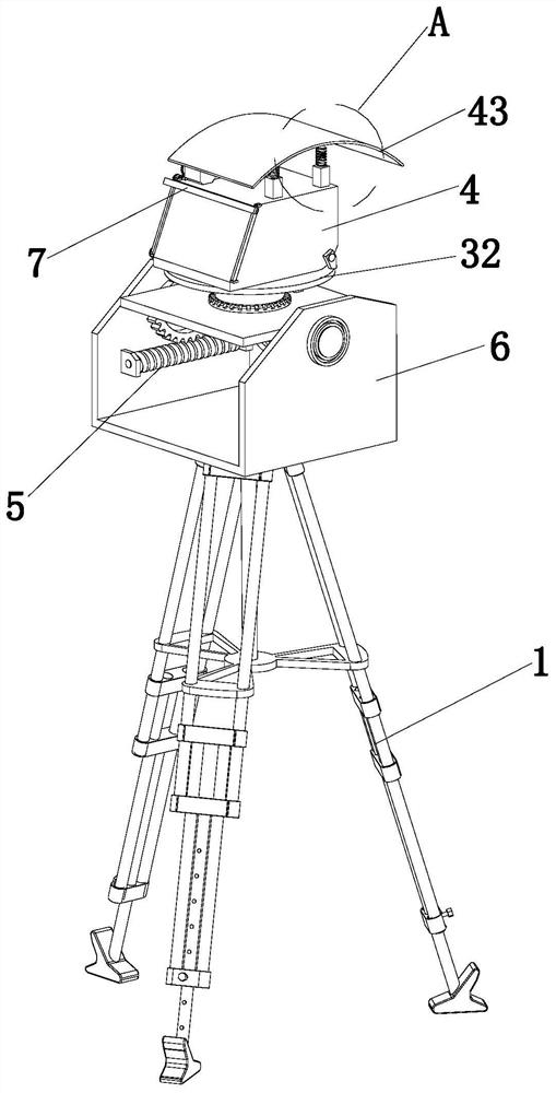
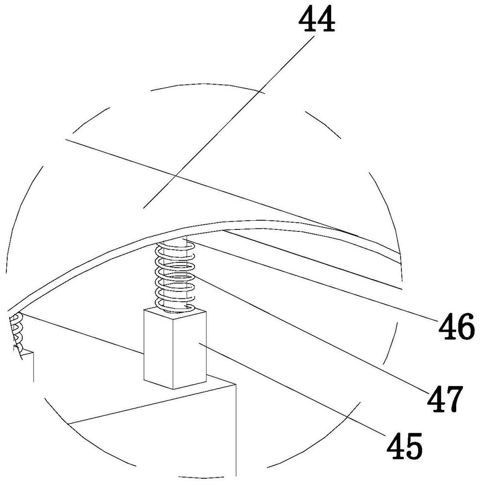
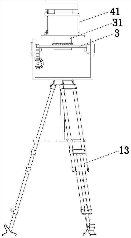
[0033]The present invention provides a kind of three-dimensional laser scanner for surveying and mapping of coal mine area through improvement, such as Figure 1-Figure 8 As shown, it includes a support lifting mechanism 1, a scanner body 2, a load plate 3, a dust-proof and anti-fall mechanism 4, a pitch angle adjustment mechanism 5, and a mounting frame 6; the mounting frame 6 is arranged on the top of the lifting end of the supporting l...


PUM


Abstract

The invention discloses a three-dimensional laser scanner for surveying and mapping a coal mine area, and belongs to the technical field of coal mine surveying equipment. The three-dimensional laser scanner comprises a supporting and lifting mechanism, a scanner body, a bearing plate, a dustproof and anti-falling mechanism, a pitching angle adjusting mechanism and a mounting frame, wherein a vertically-arranged rotating cylinder is arranged at the top part of the bearing plate, the rotating cylinder is connected with the bearing plate through a bearing, a mounting disc is arranged at the top part of the rotating cylinder, mounting columns rotationally connected with the mounting frame are arranged on the two sides of the mounting frame, and a connecting block is arranged at the end part ofeach mounting column. According to the three-dimensional laser scanner, the height of each support pad can be manually adjusted, thus the normal surveying and mapping operation of the scanner body isprevented from being influenced by the uneven coal mine area; transparent glass can be automatically wiped under the action of a coal ash wiping assembly, thus the situation that normal operation ofthe scanner body is affected due to the fact that pulverized coal adheres to the transparent glass is avoided; and the pitching angle of the scanner body can be adjusted through the pitching angle adjusting mechanism, and therefore the scanner body can adapt to different coal mine environments.

Description

technical field [0001] The invention relates to the technical field of coal mine surveying and mapping equipment, in particular to a three-dimensional laser scanner for coal mine area surveying and mapping. Background technique [0002] China is a big consumer of coal resources. The proportion of coal resources in my country's primary energy consumption is as high as about 70%. The mining of coal resources will inevitably cause different degrees of subsidence, damage, and occupation of land resources. The damaged land needs to pass through land. Reclamation and other measures to restore it to its original state and productivity level. Among them, the damage characteristics, degree of damage and distribution of the land are the most important basis for choosing reclamation techniques and measures. Due to the different coal resources in various regions The conditions of occurrence are different, the mining techniques adopted in the mining process are also different, and the char...

Claims


Application Information

Patent Timeline
Patent Type & Authority Applications(China)
IPC IPC(8): G01C15/00B08B1/00
CPCG01C15/002B08B1/002
Inventor 高炜
Owner 安徽二水测绘院有限公司
Why Eureka
Try Eureka