Digital address coding techniques for geographic positions

A digital address and geographic location technology, applied in the field of digital address coding technology, can solve problems such as incompatibility with the requirements of the times, and achieve the effect of easy determination

Pending Publication Date: 2020-10-27
冯晨
View PDF1 Cites 1 Cited by
  • Summary
  • Abstract
  • Description
  • Claims
  • Application Information

AI Technical Summary

Problems solved by technology

[0009] The technical problem to be solved by the present invention is that the various address labeling methods based on general maps have not adapted to the requirements of the times

Method used


Image

  • Digital address coding techniques for geographic positions
  • Digital address coding techniques for geographic positions
  • Digital address coding techniques for geographic positions

Examples


specific Embodiment 1

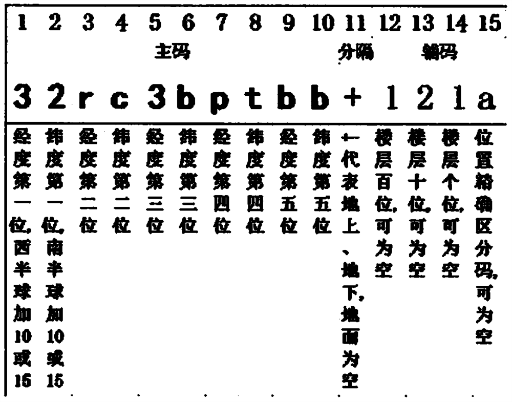
[0039] see figure 1 , figure 2 , image 3 , Figure 4 As can be seen, technical scheme of the present invention is as follows:

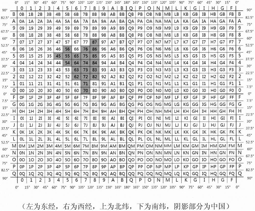
[0040] Choose a latitude and longitude map coordinate system, such as Baidu map, and obtain the latitude and longitude of a certain address point through satellite positioning terminals such as electronic maps or mobile phones, accurate to 0.000001 degrees. For example, the east longitude is 117.128195 degrees, the north latitude is 36.199646 degrees, and the floor is the 21st floor.

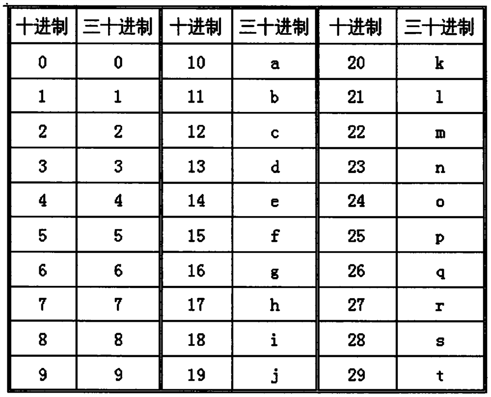
[0041] The selected longitude and latitude are multiplied by 3600 (actually converted into seconds, and then multiplied by a coefficient (after calculation and research, in order to achieve convenience and positioning accuracy, you can choose 7.5, 15, 18.75, 30, etc.). For example, the longitude coefficient is 15, and the latitude The coefficient is 30, which is converted into 6324923, 3909562.

[0042] The obtained latitude and longitude values ​​are respectivel...

specific Embodiment 2

[0050] The WeChat applet code to realize the above main functions is as follows:

[0051]

[0052] The distance between the two geographical locations marked by this code can be estimated and calculated through their respective digital address codes, and the geographical locations with the same or adjacent high-order codes are in a geographical area.


PUM


Abstract

The invention aims to provide a simple and practical geographic position labeling method. The method has the following advantages that: 1, global codes are unified; 2, the precision is high enough (the current GPS positioning precision can reach 4m level); 3, the number of bits is small (10-bit main encoding + 0-4-bit auxiliary encoding); and 4, the actual position is easy to determine (a simple formula can be directly converted into longitude and latitude). By using the coding system, a geographic position becomes simple to label, an actual position can be accurately positioned through an electronic map and GPS positioning only by providing a dozens of codes, and a simple and practical method is provided for determining the positions of manual express delivery and unmanned aerial vehicledelivery and labeling and positioning a certain area (such as fields, water areas, forests and building lands).

Description

technical field [0001] The present invention relates to a kind of geographical position of the earth (also can be aimed at other planets such as the moon), exactly a kind of digital address coding technology of geographical position. Background technique [0002] At present, with the application of global positioning systems such as the US GPS and China's Beidou and electronic maps, the original address marking methods based on general maps are no longer suitable for the requirements of the times. At present, the commonly used geographic location representation methods at home and abroad are as follows: [0003] 1. Longitude and latitude mode: the position is accurately represented, but the representation has many digits and is difficult to remember. [0004] 2. Zip code method: six digits, generally up to the county level, the range is too large. [0005] 3. House number method: XX Road XX, with the change of urban construction, the actual address cannot be accurately mar...

Claims


Application Information

Patent Timeline
Patent Type & Authority Applications(China)
IPC IPC(8): G06F16/29G06F8/30G01S19/48
CPCG01S19/48G06F8/31G06F16/29
Inventor 冯晨
Owner 冯晨
Why Eureka
Try Eureka