Dynamic baseline positioning domain monitoring method

A dynamic baseline, baseline technology, applied in the field of satellite navigation and inertial navigation, can solve problems affecting system availability, measurement errors, etc.

Active Publication Date: 2020-11-10
BEIHANG UNIV
View PDF8 Cites 2 Cited by
  • Summary
  • Abstract
  • Description
  • Claims
  • Application Information

AI Technical Summary

Problems solved by technology

At the same time, the protection level should be as small as possible under the premise of meeting the integrity requirements, otherwise it may affect the availability of the system
[0010] Therefore, in order to solve the techni

Method used


Image

  • Dynamic baseline positioning domain monitoring method
  • Dynamic baseline positioning domain monitoring method
  • Dynamic baseline positioning domain monitoring method

Examples


Embodiment Construction

[0097] The objects and functions of the present invention and methods for achieving the objects and functions will be clarified by referring to the exemplary embodiments. However, the present invention is not limited to the exemplary embodiments disclosed below; it can be implemented in various forms. The essence of the description is only to help those skilled in the relevant art comprehensively understand the specific details of the present invention.

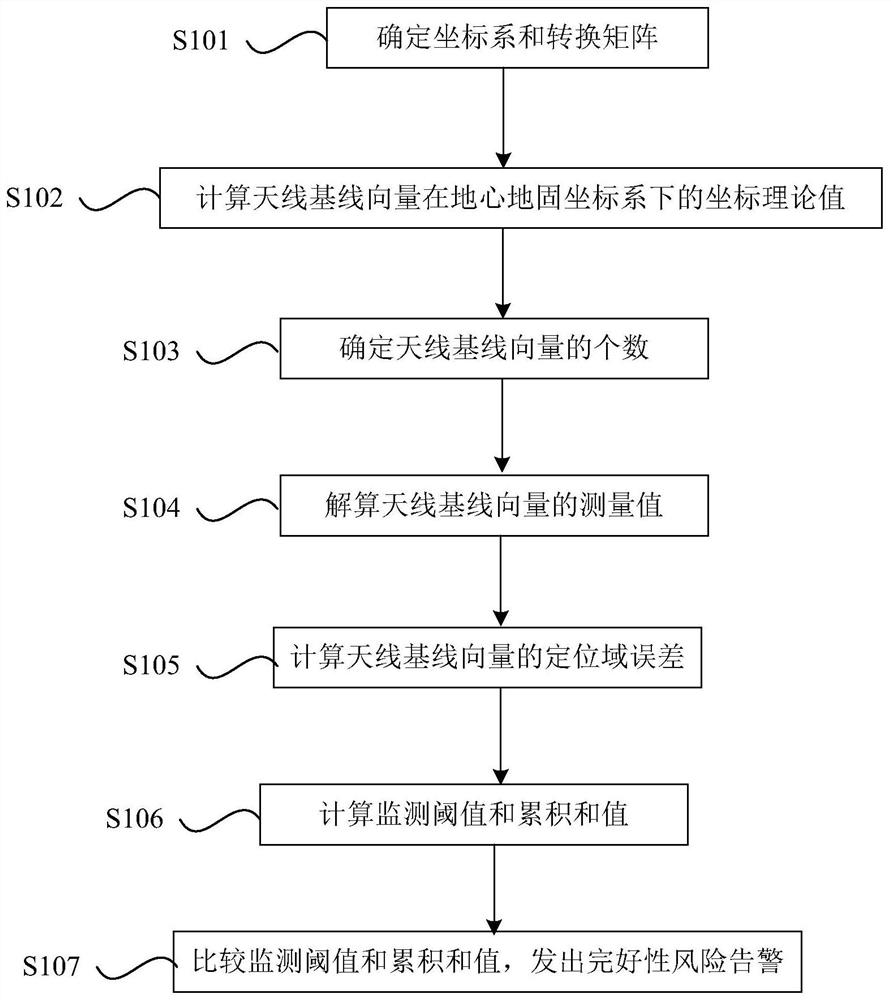
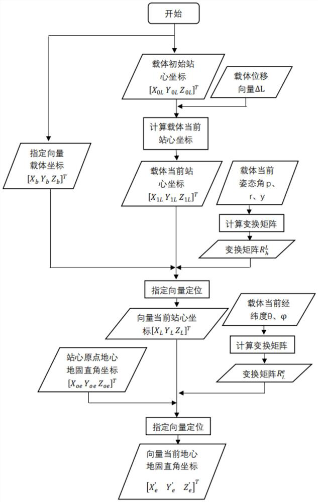
[0098] Hereinafter, embodiments of the present invention will be described with reference to the accompanying drawings, and related technical terms should be familiar to those skilled in the art. In the drawings, the same reference numerals represent the same or similar components, or the same or similar steps, unless otherwise specified. The content of the present invention will be described below through specific embodiments. In order to solve the problem in the prior art, when the antenna baseline is moving with the base ...


PUM


Abstract

The invention provides a dynamic baseline positioning domain monitoring method based on satellite navigation and inertial navigation. The method comprises the following steps: a) determining a coordinate system and a conversion matrix; b) calculating a coordinate theoretical value of the antenna baseline vector under an earth-centered earth-fixed coordinate system in the movement process of the base station carrier; c) determining the number of antenna baseline vectors to be monitored; d) resolving the measured value of the antenna baseline vector; e) calculating positioning domain errors of the antenna baseline vector change rate in x, y and z directions at the epoch k moment, and normalizing the positioning domain errors to obtain normalized values of the positioning domain errors; f) obtaining a cumulative sum value; and g) comparing the cumulative sum value with an error monitoring threshold, and sending an integrity risk alarm. According to the method, errors generated by vector position measurement of the baseline between the antennas are reduced, the accuracy of protection-level calculation is improved, the integrity risk in the aircraft dynamic-to-dynamic approach landing process is reduced, and the performance improvement of a propulsion dynamic-to-dynamic approach guiding system is facilitated.

Description

technical field [0001] The invention relates to the technical field of satellite navigation and inertial navigation, in particular to a dynamic baseline positioning domain monitoring method based on satellite navigation and inertial navigation. Background technique [0002] Differential positioning technology refers to using two global navigation satellite system (GNSS) receivers to simultaneously observe the same group of satellites and collect satellite navigation data. Different from the absolute position coordinates obtained by single-point positioning, the difference technology obtains the relative position of two receivers. If the position of one receiver is known, the precise position of the other receiver can be calculated. [0003] Ground Based Augmentation Systems (GBAS) is an important part of the satellite navigation system. Its working principle is to improve the accuracy of satellite navigation through differential positioning, and on this basis, an integrity m...

Claims


Application Information

Patent Timeline
IPC IPC(8): G01S19/49G01C21/16
CPCG01S19/49G01C21/165G01S19/44G01S19/20G01S19/15G01S19/396G01S19/04
Inventor 王志鹏朱衍波康凯方堃李强
Owner BEIHANG UNIV
Why Eureka
Try Eureka