Supercharge Your Innovation With Domain-Expert AI Agents!

Unmanned aerial vehicle navigation and positioning integrated management system based on three-dimensional 5G networking

A technology of navigation, positioning and comprehensive management, which is applied in the field of comprehensive management system of navigation and positioning of drones, and can solve the problem of low cost

Inactive Publication Date: 2020-12-18
太仓云路遥智能科技有限公司
View PDF5 Cites 0 Cited by
  • Summary
  • Abstract
  • Description
  • Claims
  • Application Information

AI Technical Summary

Problems solved by technology

Use the fixed-wing unmanned aerial vehicle system to obtain the digitization of the plot boundary and the calculation and calculation of the volume, and use the airborne measurement tools to collect the plot data and complete the preliminary data processing. The flexibility in the process is also relatively high, and it has become an important supplementary method in aerial photogrammetry, but the long-distance communication of UAVs has always been the main factor restricting the wider application of UAVs.

Method used


Image

  • Unmanned aerial vehicle navigation and positioning integrated management system based on three-dimensional 5G networking
  • Unmanned aerial vehicle navigation and positioning integrated management system based on three-dimensional 5G networking
  • Unmanned aerial vehicle navigation and positioning integrated management system based on three-dimensional 5G networking

Examples


Embodiment Construction

[0017] Hereinafter, preferred embodiments of the present invention will be described in detail with reference to the accompanying drawings. It should be understood that the preferred embodiments are only for illustrating the present invention, but not for limiting the protection scope of the present invention.

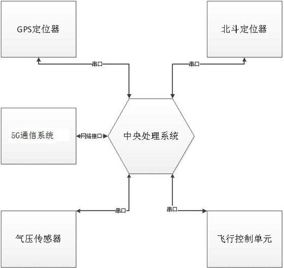
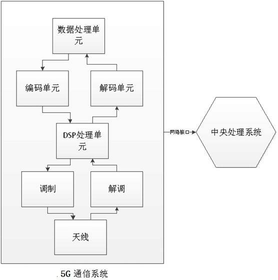
[0018] Such as figure 1 As shown, a comprehensive management system for navigation and positioning of UAVs based on 3D 5G networking, including the central processing system of UAVs, GPS and Beidou locators, 5G networking communication systems, air pressure sensors, flight control units, the GPS and Beidou locator, 5G networked communication system, air pressure sensor, flight control unit is connected with the central processing system, the GPS and Beidou locator perform positioning, the air pressure sensor is used to measure altitude, and the drone passes through the 5G networked communication system, Download the three-dimensional map data; according to the task in...


PUM


Abstract

The invention provides an unmanned aerial vehicle navigation and positioning integrated management system based on three-dimensional 5G networking. The system comprises a central processing system ofan unmanned aerial vehicle, a GPS and Beidou positioner, a 5G networking communication system, an air pressure sensor and a flight control unit, the GPS and Beidou positioner, the 5G networking communication system, the air pressure sensor and the flight control unit are connected with the central processing system; the GPS and the Beidou positioner are used for positioning, the air pressure sensor is used for measuring the altitude, and the unmanned aerial vehicle downloads three-dimensional map data through the 5G networking communication system; according to a task instruction sent by the central processing system, the flight control unit carries out flight path control, the central controller is further provided with a plurality of serial ports connected with a plurality of external hardware ports, communication is carried out through the 5G networking system, and remote high-speed data communication of the unmanned aerial vehicle can be achieved. And the navigation and positioningapplication scene and the application field of the unmanned aerial vehicle are greatly improved.

Description

technical field [0001] The invention belongs to the technical field of drones, and in particular relates to a comprehensive management system for navigation and positioning of drones based on three-dimensional 5G networking. Background technique [0002] UAVs are currently widely used in military, civil and photogrammetry fields. UAVs have the characteristics of small size and high concealment, so they are widely used in military applications. At the current stage, UAVs have been widely used in the civilian field. For example, data collection at the scene of an accident can replace manual work under harsh environmental conditions, and can also be applied to fields such as agriculture, transportation, and monitoring. UAVs have important applications in the field of photogrammetry. Use the fixed-wing unmanned aerial vehicle system to obtain the digitization of the plot boundary and the calculation and calculation of the volume, and use the airborne measurement tools to coll...

Claims


Application Information

Patent Timeline
Patent Type & Authority Applications(China)
IPC IPC(8): G05D1/10
CPCG05D1/101
Inventor 张金岳赵太飞张富强
Owner 太仓云路遥智能科技有限公司
Features
  • R&D
  • Intellectual Property
  • Life Sciences
  • Materials
  • Tech Scout
  • Unparalleled Data Quality
  • Higher Quality Content
  • 60% Fewer Hallucinations
Learn More