Map rendering method and map rendering device

A map and rendering engine technology, applied in image data processing, 3D image processing, geographic information database, etc., can solve problems such as stuck, vector tile map takes a long time, reduce the number of switching, improve efficiency, avoid Caton's effect

Pending Publication Date: 2020-12-22
HANGZHOU HIKVISION SYST TECH
View PDF0 Cites 2 Cited by
  • Summary
  • Abstract
  • Description
  • Claims
  • Application Information

AI Technical Summary

Problems solved by technology

However, in addition to the PC side, maps are becoming more and more popular in large-screen applications, and the resolution of large screens ranges from 4K pixels, 8K pixels, to 11520*4320 pixels, or even higher. The vectors that need to be displayed within the screen range The number of slices is as high as thousands or more. At this time, the traditional rendering method takes a long time to render the entire vector slice map, and the phenomenon of stuttering often occurs

Method used


Image

  • Map rendering method and map rendering device
  • Map rendering method and map rendering device
  • Map rendering method and map rendering device

Examples


Embodiment Construction

[0022] In order to make the purpose, technical means and advantages of the present application clearer, the present application will be further described in detail below in conjunction with the accompanying drawings.

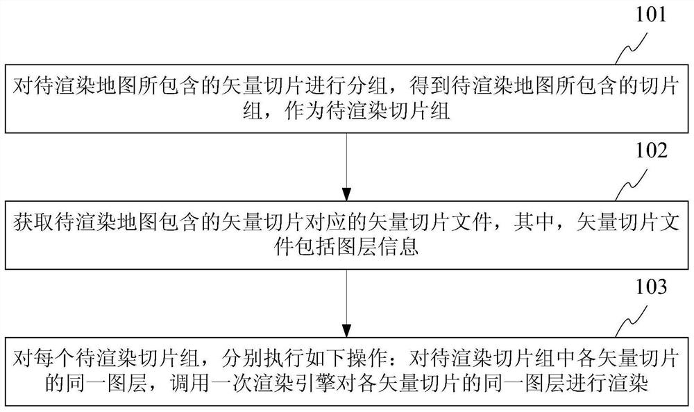
[0023] see figure 1 as shown, figure 1 It is a schematic flowchart of an exemplary map rendering method of the present application. The map rendering methods include,

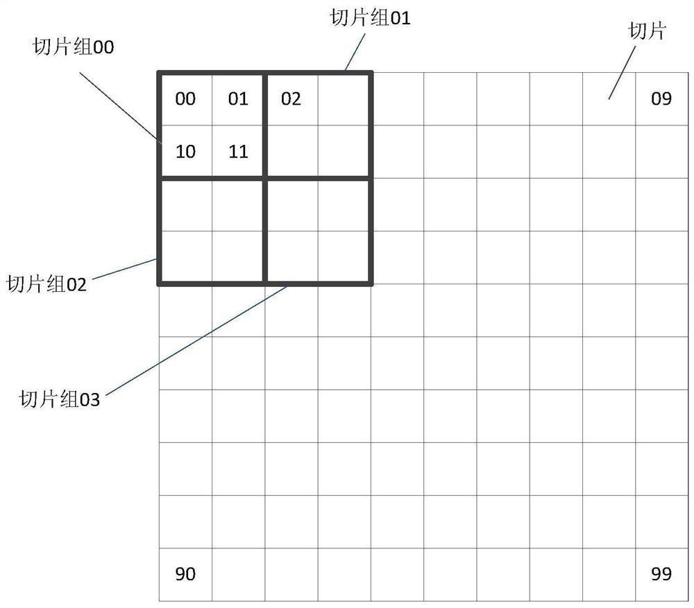
[0024] Step 101, grouping the vector slices contained in the map to be rendered to obtain the slice group contained in the map to be rendered as the slice group to be rendered;

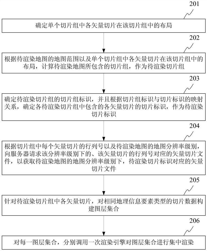
[0025] Wherein, the map to be rendered is to determine the map range to be rendered after determining display parameters such as the map resolution level and the map container size; after the map range is determined, the vector slices included in the map range can be determined.

[0026] Wherein, when the number of vector tiles included in the map to be rendered cannot be divisible by the number of vector tiles includ...


PUM


Abstract

The invention discloses a map rendering method and a map rendering device. The method comprises the steps that: vector slices contained in a to-be-rendered map are grouped, so that slice groups contained in the to-be-rendered map are obtained, and serve as to-be-rendered slice groups; a vector slice file corresponding to vector slices contained in the to-be-rendered map is obtained, wherein the vector slice file comprises layer information; and for each to-be-rendered slice group, the following operations are executed: for the same layer of each vector slice in the to-be-rendered slice group,a rendering engine is called once to render the same layer of each vector slice. According to the map rendering method and map rendering device of the invention, the same layer of each vector slice inthe single slice group is used as rendering granularity during rendering, so that the switching frequency of a shader program, the calling frequency of the rendering engine and system overhead are reduced.

Description

technical field [0001] The present invention relates to the field of Web geographic information system (WebGIS, web geographic information system), in particular, to a map rendering method and a map rendering device. Background technique [0002] During the development of WebGIS, the map has gradually developed from two-dimensional to two-dimensional and three-dimensional integration, and the rendering technology has changed from rendering based on Scalable Vector Graphics (SVG, Scalable Vector Graphics) to a cross-platform network graphics library (WebGL, Web Graphics). Library) technology, basemap data is developed from raster tiles to vector tiles. Among them, the raster slice is to cut the vector data in the form of a pyramid, and output them into pictures of a fixed size, usually 256*256 in size, which are cached on the server side for the browser client to call; the vector slice is to divide the vector data into a pyramid The output is a descriptive file of vector dat...

Claims


Application Information

Patent Timeline
IPC IPC(8): G06F16/29G06T15/00
CPCG06F16/29G06T15/005
Inventor 雷学成
Owner HANGZHOU HIKVISION SYST TECH
Why Eureka
Try Eureka