Supercharge Your Innovation With Domain-Expert AI Agents!

Miniaturized micro-electro-mechanical gyro inertia/satellite integrated navigation system

A combined navigation system and micro-electromechanical gyroscope technology, which is applied in the field of inertial navigation, can solve the problems of low installation accuracy, reduced system structural strength, and reduced sealing performance, and achieve the effects of simplified structure, small size, and reduced installation surface

Pending Publication Date: 2021-01-15
BEIJING AUTOMATION CONTROL EQUIP INST
View PDF0 Cites 1 Cited by
  • Summary
  • Abstract
  • Description
  • Claims
  • Application Information

AI Technical Summary

Problems solved by technology

Due to the advantages of continuous, high precision, non-divergence, etc., it is widely used in the fields of unmanned vehicles, unmanned aerial vehicles, robot navigation, surveying and mapping imaging load motion error compensation, railway track detection, etc. Among them, MEMS gyro inertial / satellite integrated navigation system It has the advantages of small size, light weight, low power consumption, low cost, and easy mass production. It is required for the volume of inertial measurement and integrated navigation systems in small UAVs, unmanned vehicles, robots, small guided munitions, and integrated surveying and mapping equipment. Higher fields are widely used, but the integration of inertial devices, information processing circuits, and receiver modules in a small volume has problems such as reduced system structural strength, reduced sealing performance, low installation accuracy, and poor heat dissipation, which lead to problems such as micro-electromechanical gyroscopes. The accuracy of the inertial / satellite integrated navigation system decreases, and the environmental adaptability is poor. In view of the above problems, the present invention provides a small volume and high precision MEMS gyro inertial / satellite integrated navigation system solution

Method used


Image

  • Miniaturized micro-electro-mechanical gyro inertia/satellite integrated navigation system
  • Miniaturized micro-electro-mechanical gyro inertia/satellite integrated navigation system
  • Miniaturized micro-electro-mechanical gyro inertia/satellite integrated navigation system

Examples


Embodiment Construction

[0019] The present invention will be described in further detail below in conjunction with the accompanying drawings.

[0020] The present invention is a miniaturized micro-electromechanical gyro inertial / satellite integrated navigation system, which mainly solves the problems of the current micro-electromechanical gyro inertial / satellite integrated navigation system with large volume, heavy weight, high power consumption, and low installation accuracy. .

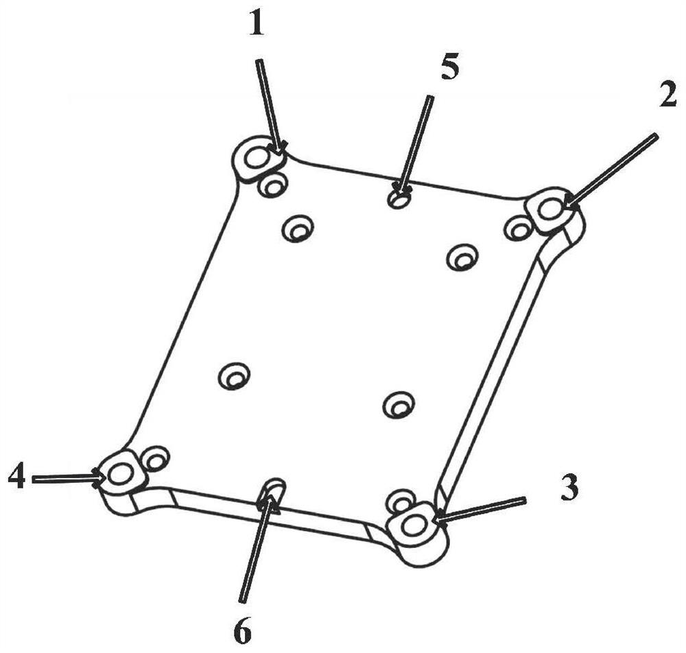
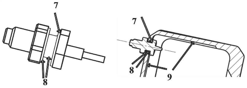
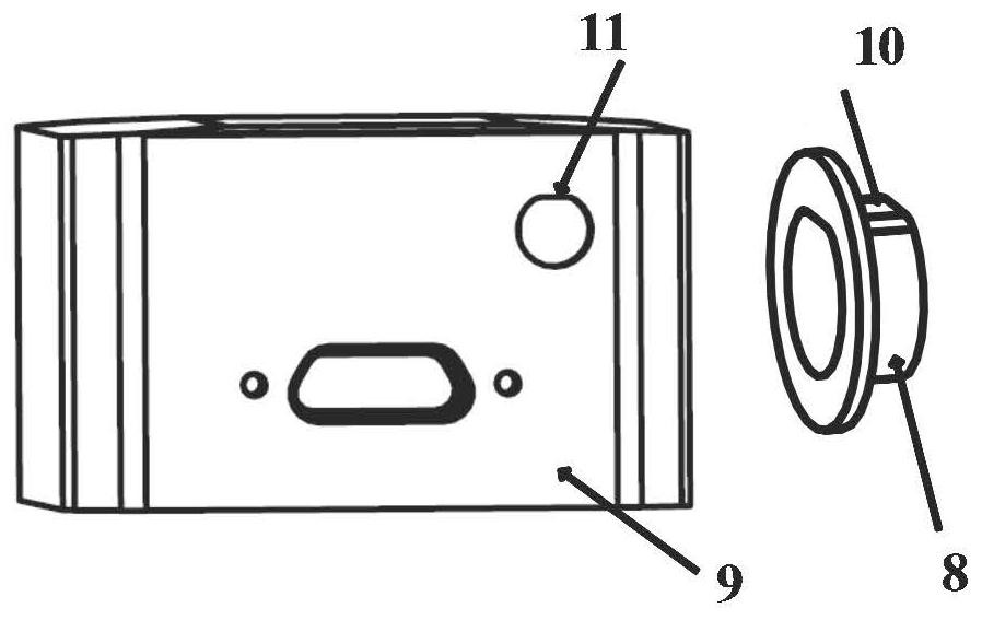
[0021] The present invention constructs an integrated navigation system consisting of a top cover, a base, an integrated navigation measurement unit, a power supply connector and a satellite receiver radio frequency connector, the base is connected with the top cover and the integrated navigation measurement unit by screws, and is The cover and the integrated navigation measurement unit provide support, and have installation references in three directions of pitch, roll and azimuth; the integrated navigation measurement uni...


PUM


Abstract

The invention discloses a miniaturized micro-electro-mechanical gyro inertia / satellite integrated navigation system, and the system is composed of a top cover, a base, an integrated navigation measurement unit, a power supply connector and a satellite receiver radio frequency connector. The base is connected with the top cover and the integrated navigation measurement unit through screws, providessupport for the top cover and the integrated navigation measurement unit, and has installation references in three directions of pitching, rolling and orientation; the integrated navigation measuringunit is composed of an inertia measuring circuit, a satellite receiver circuit and a supporting structure. The inertial measurement circuit and the satellite receiver circuit are installed on the same supporting structure, and the inertial measurement circuit is composed of an information processor, three gyroscopes and three accelerometers. According to the scheme, the inertial measurement circuit and the satellite receiver circuit of the micro-electro-mechanical gyro inertial / satellite integrated navigation system are installed on one structural body, so the installation surface is reduced,the structure is simplified, and the size is smaller.

Description

technical field [0001] The invention belongs to the technical field of inertial navigation used in aircraft and vehicles, and in particular relates to a micro-electromechanical gyro inertial / satellite integrated navigation system for inertial measurement and integrated navigation. Background technique [0002] Inertial / satellite integrated navigation measures the acceleration and angular rate movement of the carrier through inertial instruments (including accelerometers and gyroscopes), and obtains the acceleration, angular rate, attitude, position and speed of the measured carrier through error compensation and integration. At the same time, the carrier position, velocity and other information measured by the satellite navigation module are used for data fusion to form continuous high-precision inertial / satellite combination position, velocity, attitude and other information. Due to the advantages of continuous, high precision, non-divergence, etc., it is widely used in the...

Claims


Application Information

Patent Timeline
IPC IPC(8): G01C21/16G01S19/49
CPCG01C21/165G01S19/49
Inventor 陈安升扈光锋侯凤霞莫平徐兴华张凌宇刘垒王康林梦娜袁书博徐超
Owner BEIJING AUTOMATION CONTROL EQUIP INST
Features
  • R&D
  • Intellectual Property
  • Life Sciences
  • Materials
  • Tech Scout
  • Unparalleled Data Quality
  • Higher Quality Content
  • 60% Fewer Hallucinations
Learn More