Plant protection unmanned aerial vehicle real-time navigation line extraction method

A plant protection UAV and extraction method technology, applied in the field of plant protection UAV real-time navigation line extraction, can solve the problems of fruit tree canopy image interruption, fruit tree death, etc., and achieve the effect of overcoming the discontinuity phenomenon

Pending Publication Date: 2021-02-02
CHINA AGRI UNIV
View PDF0 Cites 0 Cited by
  • Summary
  • Abstract
  • Description
  • Claims
  • Application Information

AI Technical Summary

Problems solved by technology

In addition, in modern orchards, individual fruit trees may die due to diseases and insect pests, which makes the collected canopy images of fruit trees appear intermittent.

Method used


Image

  • Plant protection unmanned aerial vehicle real-time navigation line extraction method
  • Plant protection unmanned aerial vehicle real-time navigation line extraction method
  • Plant protection unmanned aerial vehicle real-time navigation line extraction method

Examples


Embodiment Construction

[0053] The present invention will be further described below in conjunction with the accompanying drawings and embodiments.

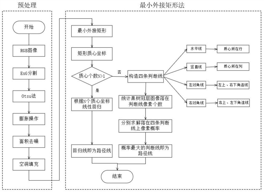
[0054] Such as figure 1 As shown, a real-time navigation line extraction method of a plant protection drone of the present invention, the navigation line is the centerline of the fruit tree canopy, and the method includes the following steps:

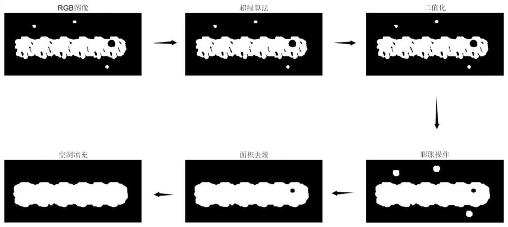
[0055] S1. Preprocessing the RGB image of the fruit tree row taken by the plant protection drone

[0056] Such as figure 2 As shown, the RGB image of the fruit tree row taken by the plant protection UAV is grayed out using the super green algorithm (ExG), ExG=2G-R-B, R represents the red channel, G represents the green channel, and B represents the blue channel; then use The imbinarize(Image,'global') function in MATLAB 2019 software uses the maximum inter-class variance method (Otsu) to binarize the grayscaled image (that is, the image only has 0 and 1) to obtain a binary image; Then use the structural eleme...


PUM


Abstract

The invention belongs to the technical field of agricultural automatic navigation, and particularly relates to a plant protection unmanned aerial vehicle real-time navigation line extraction method. The method comprises the following steps: S1, sequentially performing graying, binarization, expansion, denoising and hole filling preprocessing on a fruit tree row RGB image shot by a plant protectionunmanned aerial vehicle to obtain a preprocessed binary image; and S2, extracting a navigation line by adopting a minimum bounding rectangle method. According to the method, the minimum bounding rectangle, the pixel probability and unary linear regression are fused to comprehensively identify the center line of the fruit tree row, the influence of the possible interruption phenomenon of the fruittree canopy image is overcome, and the center lines of the horizontal, vertical and inclined fruit tree canopy images can be accurately identified. The judgment of the canopy images of the fruit trees in horizontal and inclined states can guide the adjustment of the field edge position of the plant protection unmanned aerial vehicle, so that the plant protection unmanned aerial vehicle operates in the vertical direction.

Description

technical field [0001] The invention belongs to the technical field of agricultural automatic navigation, and in particular relates to a method for extracting a real-time navigation line of a plant protection drone. The method is based on the minimum circumscribing rectangle, pixel probability and linear regression synthesis to identify the centerline of a fruit tree canopy. Background technique [0002] With the advent of the era of precision agriculture, the requirements for the control of farmland diseases and insect pests are getting higher and higher. Low pollution, high efficiency and low cost are the development trend of agricultural plant protection in the future. Unmanned aerial vehicles (UVA), the main tool for agricultural aviation operations, have great prospects for development. When using plant protection drones to spray pesticides, it is necessary to plan the pesticide application path in advance. This method is time-consuming and laborious, and the timelines...

Claims


Application Information

Patent Timeline
Patent Type & Authority Applications(China)
IPC IPC(8): G06F16/29
CPCG06F16/29
Inventor 祁力钧万军杰程浈浈张豪周佳蕊
Owner CHINA AGRI UNIV
Why Eureka
Try Eureka