Running track algorithm based on satellite positioning

A running track and satellite positioning technology, which is applied in satellite radio beacon positioning systems, telephone communications, instruments, etc., can solve the problems of not smooth enough tracks, poor accuracy of motion positioning points, large mileage deviation, etc., to ensure stability and rationality, avoiding large trajectory distortion, and reducing the effect of length error

Active Publication Date: 2021-03-16
厦门家康天下科技股份有限公司
View PDF6 Cites 2 Cited by
  • Summary
  • Abstract
  • Description
  • Claims
  • Application Information

AI Technical Summary

Problems solved by technology

Due to the limitation of the calculation method adopted by the existing sports APP, in the actual application of the APP, it is affected by the problems of bad weather, buildings, mountains and other obstacles in the surrounding environment, and the accuracy of monitoring the user's motion positioning point based on satellite positioning is not good. question
The main manifestations include the following three types: 1. The first point positioning is not accurate enough. When the user opens the APP and the GPS positioning of the APP is working, if there are high-rise buildings or cloudy weather around, the GPS positioning is far from the actual real positioning point. 2. Large-scale trajectory distortion. During running, if the GPS signal suddenly becomes weak, there

Method used


Image

  • Running track algorithm based on satellite positioning
  • Running track algorithm based on satellite positioning
  • Running track algorithm based on satellite positioning

Examples


Embodiment Construction

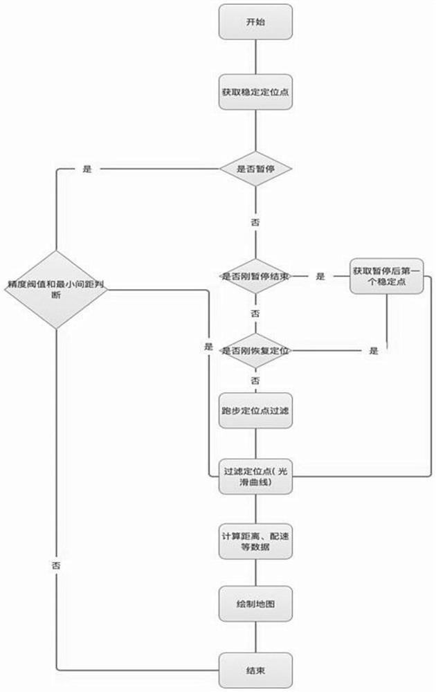
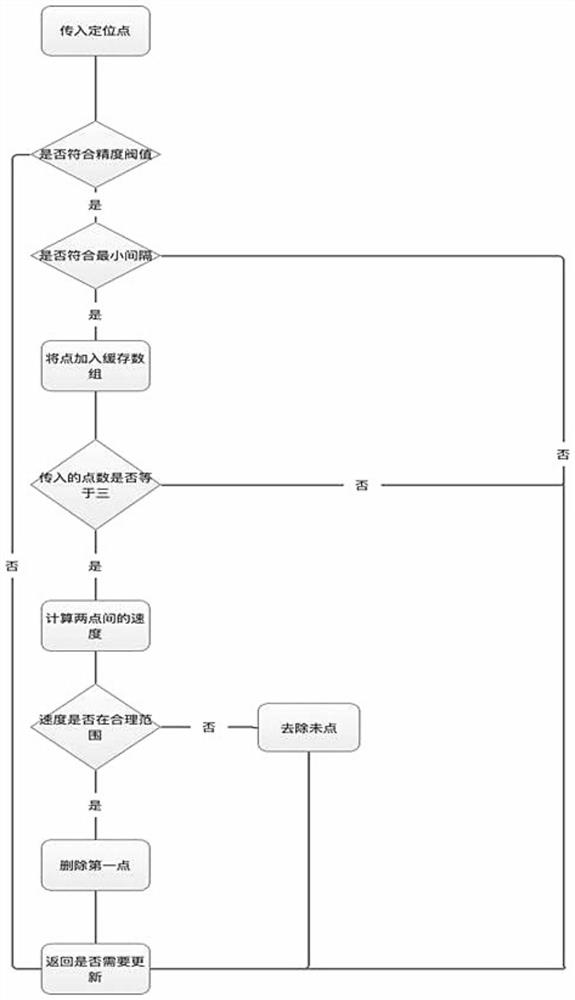
[0013] figure 1 , 2 , shown in 3, a kind of running track algorithm based on satellite positioning, calculation comprises the following steps: Step A, obtains a stable positioning point through GPS; The positioning point (also called end point data) data obtained from the entrance of GPS or base station. Step 2: Calculate and judge whether the data of the positioning point meets the accuracy threshold according to different types of positioning points (generally including: satellite, base station, WIFI, etc.). Step 3. Calculate and judge whether the positioning point data in step 2 conforms to the latest interval (the distance between two points, the unit is calculated in m); the calculation method is as follows figure 2 , L>(0.2*t+1) (the unit of L is m, and t represents the interval time); step 4, calculate the speed of two points (the latest two positioning points); step 5, calculate and judge whether the speed is reasonable (details See Pace Rationality Rules), that is...


PUM


Abstract

The invention discloses a running track algorithm based on satellite positioning. Calculation comprises the following steps: A, obtaining stable positioning points through a GPS; B, calculating whether positioning is temporary or not; C, calculating whether positioning is just suspended or not; D, calculating whether the positioning point is just recovered or not; E, calculating and filtering running positioning points; F, calculating a filtering positioning point to realize a smooth curve; G, calculating corresponding data such as matching speed, distance and the like; H, drawing a map. According to the method, the first point appears at the position close to the real position, the accuracy of the first point is improved, and the running track length error is reduced. Large-amplitude track distortion is avoided; and if no positioning exists for a period of time, the obtained stable point is subjected to smooth calculation again, and the position of the positioning point is changed within a certain range, so that the running track displayed on the APP interface is smoother and more attractive when being observed by naked eyes, and is closer to a real value in total mileage, and a powerful technical support is provided for ensuring effective application of the running APP.

Description

technical field [0001] The invention relates to the technical field of algorithms used in mobile phone APP positioning technology, in particular to a running track algorithm based on satellite positioning. Background technique [0002] With the popularization of smart phones, there are more and more mobile apps, among which sports apps are one of them. In order to ensure the effective application of sports APP, the motion trajectory calculation method is widely used in sports APP. Due to the limitation of the calculation method adopted by the existing sports APP, in the actual application of the APP, it is affected by the problems of bad weather, buildings, mountains and other obstacles in the surrounding environment, and the accuracy of monitoring the user's motion positioning point based on satellite positioning is not good. question. The main manifestations include the following three types: 1. The first point positioning is not accurate enough. When the user opens the ...

Claims


Application Information

Patent Timeline
IPC IPC(8): H04M1/72457G01S19/19G01S19/39
CPCG01S19/19G01S19/393
Inventor 陈雪峰凌振黄沈鸿
Owner 厦门家康天下科技股份有限公司
Why Eureka
Try Eureka