Land surveying and mapping measuring line tightening equipment based on electronic information technology

A technology of electronic information and measuring lines, which is applied in the directions of measuring devices, measuring instruments, surveying and navigation, etc., can solve the problems that the measuring lines are easy to be rolled up in one place, cannot be fastened to the user, and cannot be completed independently, so as to achieve convenience Land surveying and mapping operation, convenient to carry out, good practical effect

Pending Publication Date: 2021-04-02
王霞
View PDF10 Cites 3 Cited by
  • Summary
  • Abstract
  • Description
  • Claims
  • Application Information

AI Technical Summary

Problems solved by technology

[0003] At present, when using the surveying line for land surveying and mapping, more than two people need to cooperate to complete the land

Method used


Image

  • Land surveying and mapping measuring line tightening equipment based on electronic information technology
  • Land surveying and mapping measuring line tightening equipment based on electronic information technology
  • Land surveying and mapping measuring line tightening equipment based on electronic information technology

Examples


Embodiment Construction

[0025] The following will clearly and completely describe the technical solutions in the embodiments of the present invention with reference to the accompanying drawings in the embodiments of the present invention. Obviously, the described embodiments are only some of the embodiments of the present invention, not all of them. Based on the embodiments of the present invention, all other embodiments obtained by persons of ordinary skill in the art without making creative efforts belong to the protection scope of the present invention.

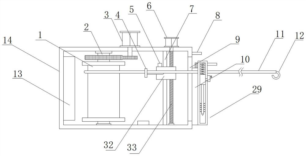
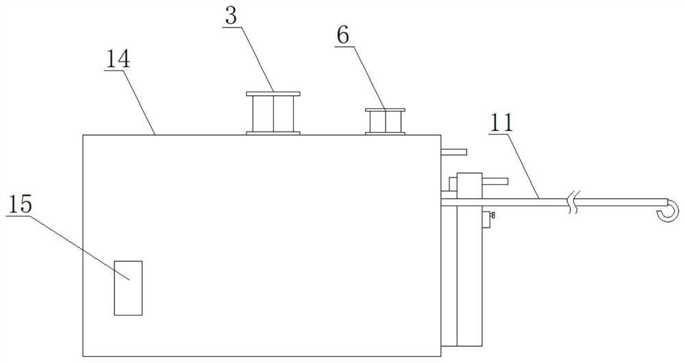
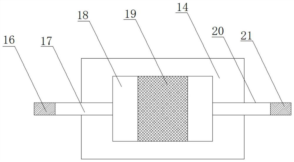
[0026] see Figure 1-7, in an embodiment of the present invention, a land surveying and mapping measuring line tightening device based on electronic information technology includes a take-up reel 1, a vertical rod 2, a first motor 3, a guide coil 4, a distance sensor 5, a second motor 6, Slide rail 7, first hanging ring 8, first through hole 9, fixed block 10, measuring line 11, hook 12, battery 13, box body 14, controller 15, Velcro rough surfac...


PUM


Abstract

The invention discloses land surveying and mapping measuring line tightening equipment based on an electronic information technology. The land surveying and mapping measuring line tightening equipmentbased on the electronic information technology comprises a first motor, a second motor, a box body and a take-up wheel. The first motor rotates to drive the take-up wheel to rotate, so that a measuring line is stretched; hook-and-loop fastener loop sides and hook-and-loop fastener hook sides on a first binding band and a second binding band are used in cooperation, so that an arc-shaped plate isbound to the arm of a user, the easiness in operation is achieved, a user can carry the box body conveniently, and land surveying and mapping work can be carried out conveniently; the second motor rotates to drive a lead screw to rotate, so that a sliding block is driven to move on the lead screw, and a wire coil is further driven to move; and a distance sensor is arranged and used for sensing thedistance between the sliding block and the top of the inner side of the box body, so that the second motor can rotate conveniently to drive the sliding block to move up and down on the lead screw, the wire coil is driven to move up and down, and the measuring line can be conveniently wound at different positions of the take-up wheel so as to be prevented from being wound at one position.

Description

technical field [0001] The invention relates to a tightening device, in particular to a land surveying and mapping measuring line tightening device based on electronic information technology. Background technique [0002] Land surveying and mapping refers to the use of computer technology, photoelectric technology, network communication technology, space science, and information science as the basis, with the global positioning system, remote sensing, and geographic information system as the technical core, to map the existing feature points and boundaries on the ground through measurement It is used to obtain graphics and location information reflecting the current situation of the ground for the planning, design and administrative management of engineering construction. The survey line is one of the commonly used tools in the field of land surveying and mapping. [0003] At present, when using the surveying line for land surveying and mapping, more than two people need to ...

Claims


Application Information

Patent Timeline
IPC IPC(8): B65H75/44B65H75/40G01C15/00
CPCB65H75/44B65H75/4486B65H75/4405B65H75/406G01C15/00B65H2701/36
Inventor 王霞赵才
Owner 王霞
Why Eureka
Try Eureka