Mine ground surface settlement monitoring system

A technology of land subsidence and monitoring system, which is applied in the direction of radio wave measurement system, satellite radio beacon positioning system, measurement device, etc. It can solve the problems of backward monitoring methods, changing the surface environment, and inconvenient monitoring data collection, etc., to achieve good protection Effect, good lightning protection effect, convenient and flexible release effect

Pending Publication Date: 2021-04-06
北京岩土工程勘察院有限公司
View PDF0 Cites 0 Cited by
  • Summary
  • Abstract
  • Description
  • Claims
  • Application Information

AI Technical Summary

Problems solved by technology

[0002] With the rapid development of the economy and society, the demand for mineral products is increasing, and many minerals need to be mined underground. Due to the stress balance factor, with the increase of the volume of the mining area and the passage of time, the surface of the mining area often results in subsidence or Subsidence, thereby affecting the safe production of mines; causing damage to farmland, damage to ground buildings, and changes to the surface environment
[0003] Therefore, it is necessary to effectively monitor the surface subsidence in the mining area, but the existing monitoring methods are relatively backward, and hand-held GPS measuring instruments and manual visual monitoring are still used. The monitoring tools are mainly GPS, steel tape measure, benchmark, tape measure, etc. The measurement accuracy cannot meet the monitoring requirements of the mine geological environment, the monitoring data collection is inconvenient, and the accuracy and continuity of the data cannot be guaranteed. Further improvement is urgently needed to ensure the safety of the land and residents around the mining area

Method used


Image

  • Mine ground surface settlement monitoring system
  • Mine ground surface settlement monitoring system
  • Mine ground surface settlement monitoring system

Examples


Embodiment Construction

[0033] The application will be described in further detail below in conjunction with the accompanying drawings.

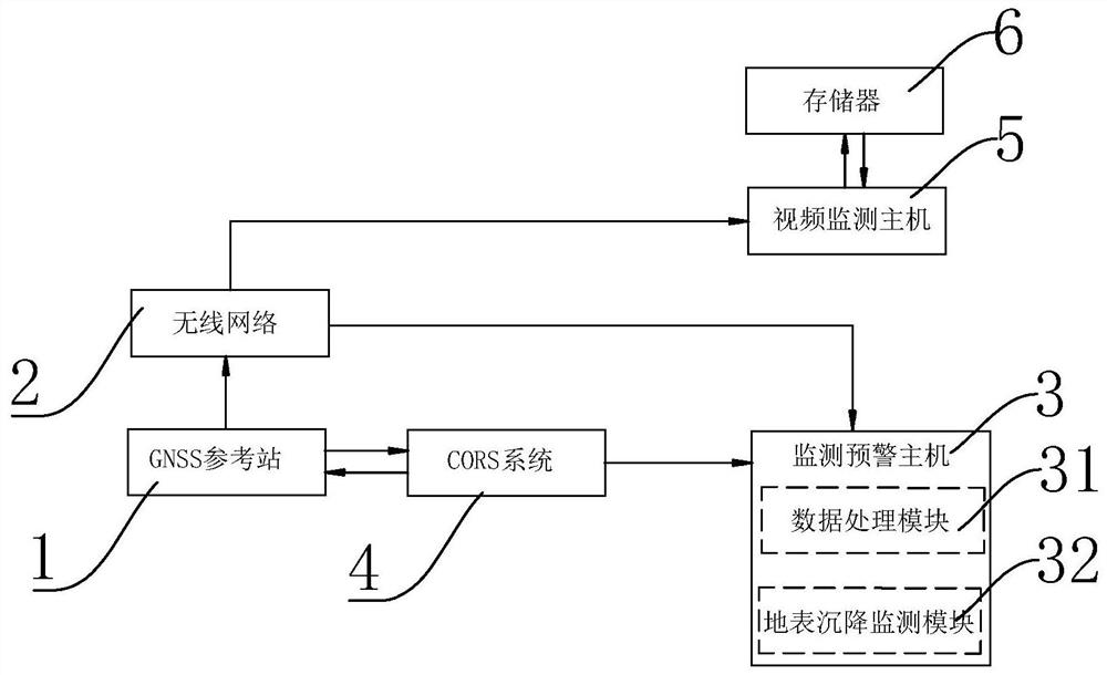
[0034] Such as figure 1 As shown, a mine surface subsidence monitoring system includes a plurality of GNSS reference stations 1, a wireless network 2 and a monitoring and early warning host 3.

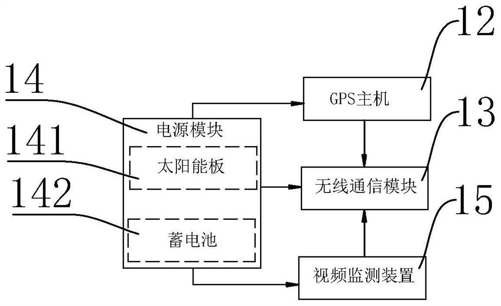
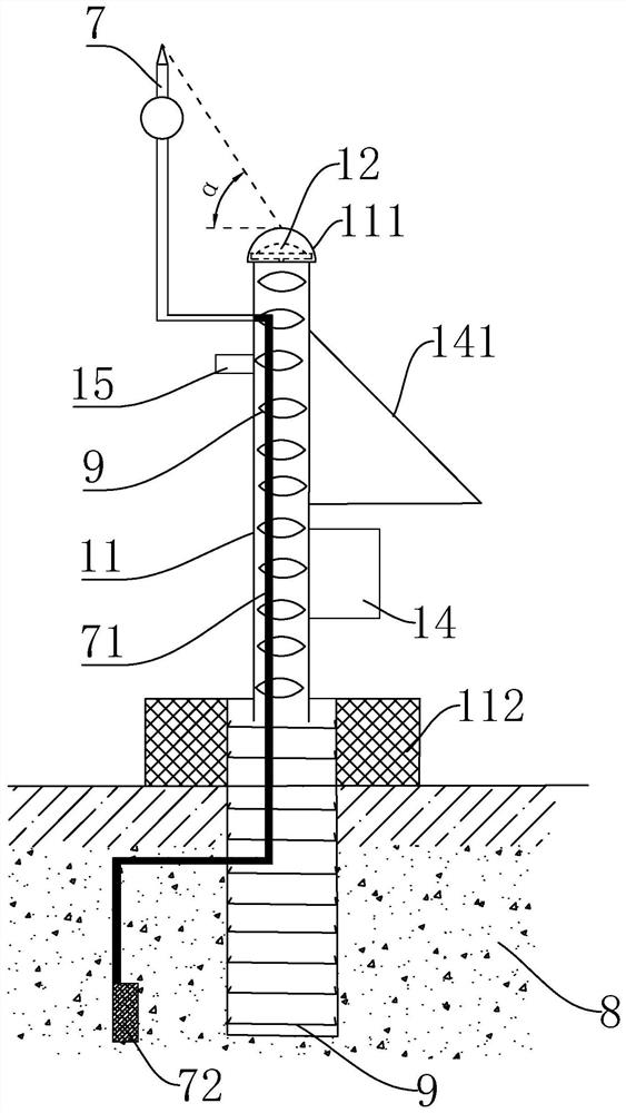
[0035] Such as figure 1 , 2 As shown, the GNSS reference station 1 is arranged on the surface of the mine monitoring area; the GNSS reference station 1 includes a GPS host 12, a wireless communication module 13 and a power supply module 14 installed on the vertical pier 11; the wireless communication module 13 of the present embodiment adopts 3G or 4G communication module, 3G or 4G communication module can carry out wireless communication of wireless communication protocol, reducing network construction and operating costs. The power module 14 includes a solar panel 141 and a battery 142 , and the solar panel 141 is electrically connected to the battery 142 . The solar ...


PUM


Abstract

The invention relates to a mine ground surface settlement monitoring system which comprises a plurality of GNSS reference stations, a wireless network and a monitoring and early warning host. The GNSS reference stations are arranged on the ground surface of a mine monitoring area. Each GNSS reference station comprises a GPS host, a wireless communication module and a power supply module which are installed on a vertical pier column. The GPS host receives continuous GPS positioning information sent by the CORS system, generates real-time three-dimensional GPS positioning data of the earth surface, and sends the real-time three-dimensional GPS positioning data to the monitoring and early warning host through the wireless communication module via a wireless network; the CORS system sends GPS positioning information to the GPS host and generates corresponding surface subsidence data of the GNSS reference station through processing, and the surface subsidence data is transmitted to the monitoring and early warning host in real time through the CORS system; and the monitoring and early warning host receives the real-time three-dimensional GPS positioning data and the real-time surface subsidence data. The mine ground surface settlement monitoring system can monitor mine ground surface settlement in real time and has the advantages of being stable in system, capable of achieving all-weather monitoring and long-distance information transmission and flexible and diverse in early warning mode.

Description

technical field [0001] The present application relates to the technical field of geological monitoring, in particular to a mine surface subsidence monitoring system. Background technique [0002] With the rapid development of economy and society, the demand for mineral products is increasing, and many minerals need to be mined underground. Due to the stress balance factor, with the increase of the volume of the mining area and the passage of time, the surface of the mining area often results in subsidence or Subsidence will affect the safe production of mines; it will cause damage to farmland, damage to ground buildings, and change the surface environment. [0003] Therefore, it is necessary to effectively monitor the surface subsidence in the mining area, but the existing monitoring methods are relatively backward, and hand-held GPS measuring instruments and manual visual monitoring are still used. The monitoring tools are mainly GPS, steel tape measure, benchmark, tape mea...

Claims


Application Information

Patent Timeline
IPC IPC(8): G01C5/00G01S19/42H01T19/04
CPCG01C5/00G01S19/42H01T19/04
Inventor 贾国凯何怀峰甘玉叶刘军柱冯康楠张强苗长魏宪平王聪苗艳茹刘松李小军夏连香陈伟万里鹏邓园园张智博钟金金
Owner 北京岩土工程勘察院有限公司
Why Eureka
Try Eureka