
Track planning method and device, medium and unmanned device

A trajectory planning and equipment technology, applied in the direction of instruments, surveying and mapping and navigation, measuring devices, etc., can solve problems such as large computing resources and the impact of subsequent driving of unmanned vehicles, so as to avoid excessive distance, save planning resources, and improve efficiency Effect

Pending Publication Date: 2021-04-13
BEIJING SANKUAI ONLINE TECH CO LTD
View PDF0 Cites 2 Cited by
  • Summary
  • Abstract
  • Description
  • Claims
  • Application Information

AI Technical Summary

Problems solved by technology

However, in practical applications, it is found that using the closest point projection method to determine the projected coordinates of obstacles on these complex roads, it is easy to have a large distance between the determined projected coordinates and the actual position of the obstacle corresponding to the position coordinates in the road coordinate system. Therefore, it consumes more computing resources to plan the driving trajectory for the unmanned vehicle based on the projected coordinates, and the planned driving trajectory is not necessarily optimal, and even seriously affects the subsequent driving of the unmanned vehicle ( For example: causing driverless vehicles to go nowhere later)

Method used


Image

  • Track planning method and device, medium and unmanned device
  • Track planning method and device, medium and unmanned device
  • Track planning method and device, medium and unmanned device

Examples


Embodiment Construction

[0063] In practical applications, when planning a driving trajectory for an unmanned device, first, a road coordinate system needs to be constructed. Usually along the driving direction of the unmanned equipment, a road coordinate system (SL coordinate system) is constructed based on the centerline of the road on which it is traveling. That is, along the driving direction of the unmanned equipment, the center line of the road being driven is the S axis of the road coordinate system; the L axis of the road coordinate system is constructed perpendicular to the S axis. Secondly, according to the conversion relationship between the world coordinate system and the road coordinate system, determine the position of the obstacle in the road coordinate system (that is, the projected coordinates). Finally, based on the projected coordinates of the determined obstacles, the driving trajectory is planned for the unmanned device.

[0064] However, due to the complexity of the road on whic...


PUM


Abstract

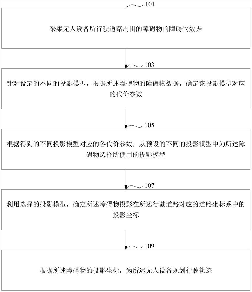
The invention discloses a track planning method and device, a medium and an unmanned device. The track planning method comprises the steps of collecting obstacle data of obstacles around a road where the unmanned device runs; for different set projection models, determining cost parameters corresponding to the projection models according to the obstacle data of the obstacles; according to the obtained cost parameters corresponding to the different projection models, selecting a used projection model for the obstacle from the preset different projection models; determining projection coordinates of the obstacle projection in a road coordinate system corresponding to the running road by using the selected projection model; and planning a driving track for the unmanned device according to the projection coordinates of the obstacle. Therefore, the appropriate projection model is selected for the difficulty of planning the driving track for the unmanned device, the planned driving track can be ensured to reasonably avoid the obstacles, planning resources are saved, and the efficiency of planning the driving track for the unmanned device is improved.

Description

technical field [0001] This specification relates to the field of unmanned driving technology, in particular to a trajectory planning method, equipment, medium and unmanned equipment. Background technique [0002] With the development of artificial intelligence technology, computer technology and Internet of Vehicles technology, unmanned driving technology has emerged as the times require. With the unmanned driving technology, unmanned vehicles have also received widespread attention. [0003] In order to ensure the driving safety of unmanned vehicles, it is necessary to provide reasonable and effective driving paths for unmanned vehicles. A trajectory planning module is usually deployed in an unmanned vehicle, and the trajectory planning module is mainly used to plan a local driving path for the unmanned vehicle. [0004] When planning the trajectory of an unmanned vehicle, it is necessary to consider the obstacles around the unmanned vehicle to ensure that the planned tr...

Claims


Application Information

Patent Timeline
IPC IPC(8): G01C21/34G05D1/02
CPCG01C21/3415G01C21/3446G05D1/0214
Inventor 林伟
Owner BEIJING SANKUAI ONLINE TECH CO LTD
Learn More