Remote sensing satellite super-resolution method and device of multi-scale texture transfer residual network

A remote sensing satellite, multi-scale technology, applied in the field of remote sensing satellite image super-resolution, which can solve the problems of reconstruction performance, remote sensing satellite image quality limitation, etc.

Active Publication Date: 2021-04-30
WUHAN INSTITUTE OF TECHNOLOGY
View PDF13 Cites 4 Cited by
  • Summary
  • Abstract
  • Description
  • Claims
  • Application Information

AI Technical Summary

Problems solved by technology

However, the above-mentioned remote sensing satellite super-resolution reconstruction algorithm has certain limitations in network reconstruction performance and remote sensing satellite image quality.

Method used


Image

  • Remote sensing satellite super-resolution method and device of multi-scale texture transfer residual network
  • Remote sensing satellite super-resolution method and device of multi-scale texture transfer residual network
  • Remote sensing satellite super-resolution method and device of multi-scale texture transfer residual network

Examples


Embodiment 1

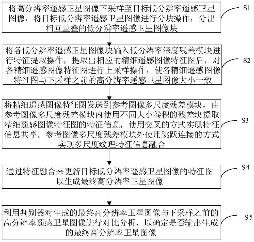
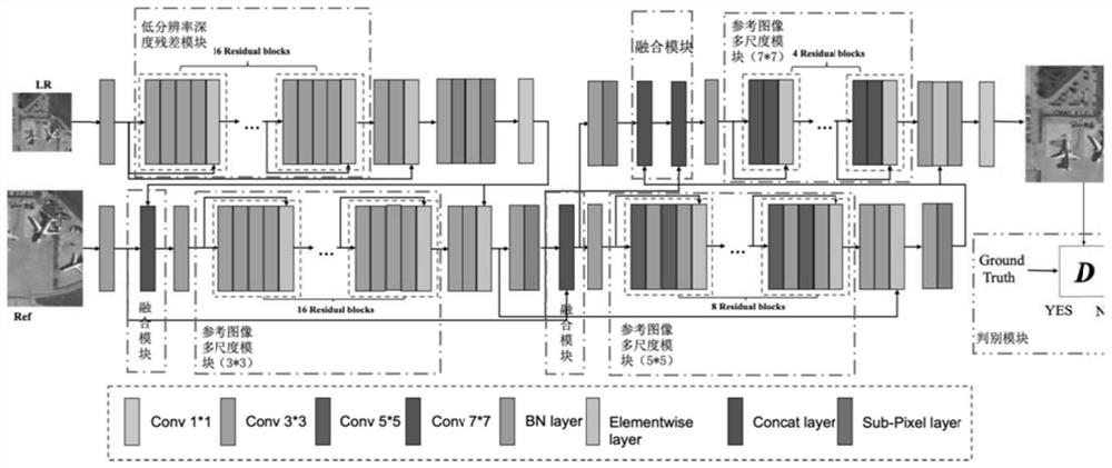
[0042] The invention proposes a remote sensing satellite super-resolution method based on a multi-scale texture transfer residual network. The remote sensing satellite super-resolution method uses a low-resolution depth residual module to obtain fine low-resolution image features. Then use the reference image multi-scale residual module to extract multi-scale texture information, through the effective transfer of the extracted multi-scale texture information to obtain better visual effects.

[0043] figure 1 It is a schematic flow chart of a remote sensing satellite super-resolution method provided by a multi-scale texture transfer residual network provided by an embodiment of the present invention, as shown in figure 2 Shown is the overall network structure of a multi-scale texture transfer residual network remote sensing satellite super-resolution method proposed by the embodiment of the present invention, through the low-resolution depth residual module, the reference ima...

Embodiment 2

[0062] Embodiment two, test embodiment:

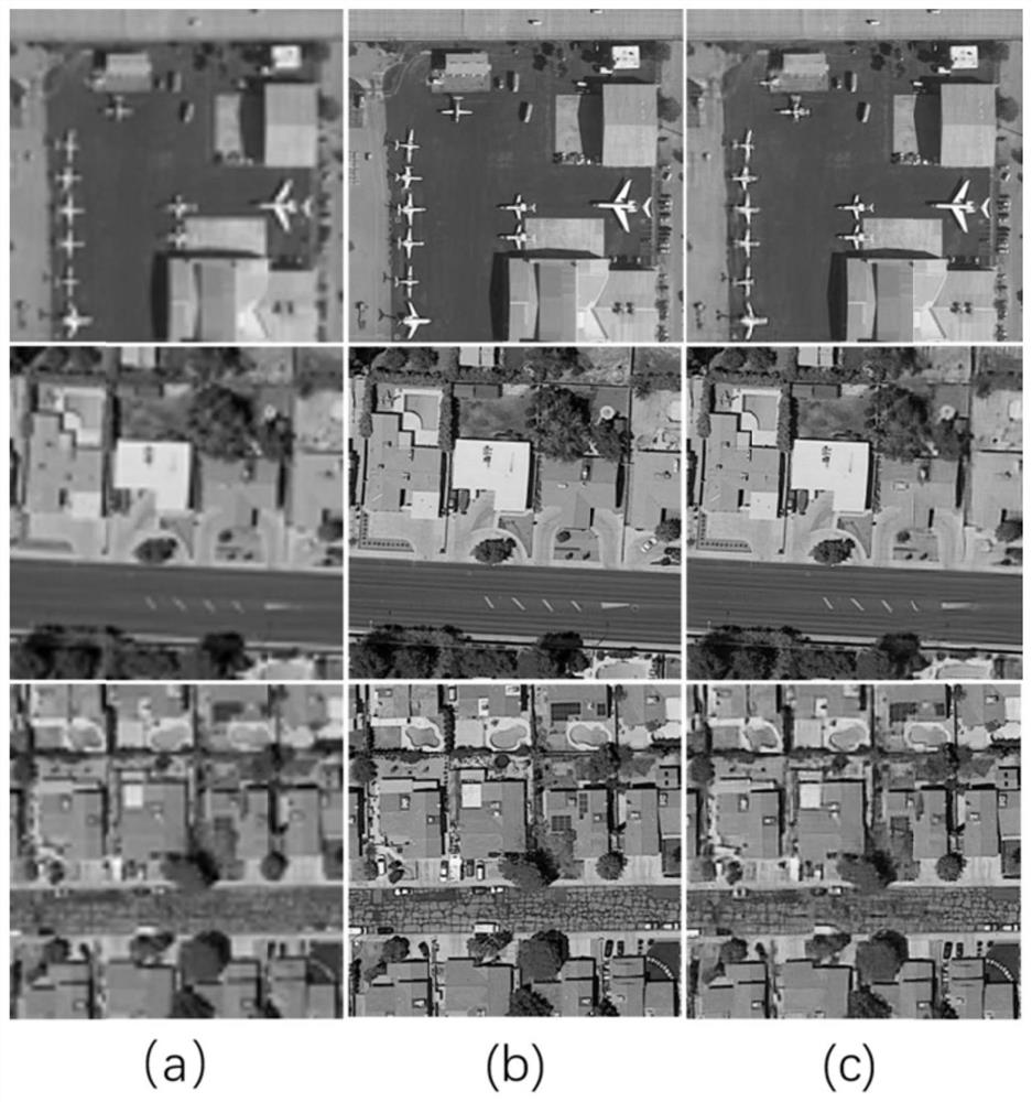
[0063]The experiment uses the remote sensing satellite database released by Kaggle. This database contains a large number of high-resolution remote sensing satellite pictures. The size of each picture is adjusted to 320×320 pixels, and the corresponding low-resolution image size is 80×80 by downsampling four times. Pixels, extract low-resolution remote sensing satellite image blocks as 16×16 pixels.

[0064] Compared with other image super-resolution reconstruction algorithms, the inventive method provides experimental data to express the effectiveness of the inventive method, and the parameters of the comparative experimental results are compared as shown in the following table 1, and table 1 is 25 remote sensing satellite images comparative experimental results (average PSNR, SSIM and VIF), the experimental results are as follows image 3 As shown, (a) is a Bicubic image; (b) is an original high-resolution image; (c) is a diagram of...

Embodiment 3

[0070] In another embodiment of the present invention, as Figure 4 A schematic diagram of the structure of a remote sensing satellite super-resolution device based on a multi-scale texture transfer residual network is provided, including:

[0071] The blocking module is used for down-sampling the high-resolution remote sensing satellite image to the target low-resolution remote sensing satellite image, performing block operation on the target low-resolution remote sensing satellite image, and separating overlapping low-resolution remote sensing satellite image blocks;

[0072] The low-resolution depth residual module is used to input each low-resolution remote sensing satellite image block into the low-resolution depth residual module for feature extraction operation. After extracting the corresponding fine remote sensing image feature map, each fine remote sensing image feature map Perform an upsampling operation to make the feature maps of each fine remote sensing image con...


PUM


Abstract

The invention discloses a remote sensing satellite super-resolution method and device of a multi-scale texture transfer residual error network, and belongs to the field of remote sensing satellite image super-resolution. The method comprises the steps: carrying out the feature extraction of a target low-resolution image after down-sampling through a depth residual error network, carrying out the two times of up-sampling operation of an extracted feature map, and obtaining a target low-resolution image; wherein the size of the image is consistent with that of an original high-resolution satellite image; feature information of the feature map is extracted by using different convolution residual blocks in the multi-scale residual module, feature information sharing is realized by using a cross mode, and multi-scale feature information fusion is realized by using a jump connection mode outside the residual module; updating the feature map of the target low-resolution satellite image through feature fusion to generate a final high-resolution satellite image; and comparing the generated high-resolution image with the original high-resolution image by using a discriminator. The network provided by the invention is superior to other latest remote sensing satellite image super-resolution algorithms, and satellite images with higher quality can be generated.

Description

technical field [0001] The invention belongs to the technical field of remote sensing satellite image super-resolution, and more specifically relates to a remote sensing satellite super-resolution method and device of a multi-scale texture transfer residual network. Background technique [0002] Remote Sensing Satellites (Remote Sensing Satellites) is an important ground detection method that has developed rapidly in recent years. Due to their unique advantages of wide coverage, strong real-time performance and no environmental constraints such as terrain, they are used in disaster detection and early warning, resource exploration and land cover classification. It has broad application prospects in environmental testing and other fields. [0003] Due to the special value of high-quality satellite images in application scenarios, Single Image Super-Resolution (SISR) methods for remote sensing satellite images have attracted more and more attention recently. In addition to s...

Claims


Application Information

Patent Timeline
Patent Type & Authority Applications(China)
IPC IPC(8): G06T3/40G06K9/00G06K9/46G06K9/62
CPCG06T3/4053G06V20/13G06V10/40G06F18/253
Inventor 卢涛饶宁王宇刘威张彦铎吴云韬于宝成
Owner WUHAN INSTITUTE OF TECHNOLOGY
Why Eureka
Try Eureka