Urban construction land expansion and population growth relative coordination degree evaluation method and system

A construction land and urban construction technology, applied in data processing applications, instruments, calculations, etc., can solve problems such as inconsistencies in coordination results, influence on coordination results, lack of consideration of whether the construction land and the total population match, etc., to achieve sustainable Strong operability, low technical threshold and high reproducibility

Active Publication Date: 2021-05-18
WUHAN UNIV
View PDF4 Cites 0 Cited by
  • Summary
  • Abstract
  • Description
  • Claims
  • Application Information

AI Technical Summary

Problems solved by technology

[0005] This ideal state only considers the absolute coordination relationship between the growth rates of the two in the process of urban development, and lacks consideration of whether the initial construction land and the to

Method used


Image

  • Urban construction land expansion and population growth relative coordination degree evaluation method and system
  • Urban construction land expansion and population growth relative coordination degree evaluation method and system
  • Urban construction land expansion and population growth relative coordination degree evaluation method and system

Examples


Embodiment Construction

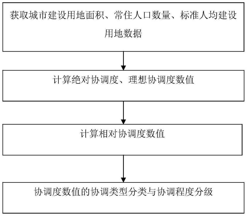
[0038] The technical solutions of the present invention will be described in detail below in conjunction with the accompanying drawings and embodiments.

[0039] The core problem to be solved by the present invention is: determination of the ideal state and relative coordination degree of urban construction land growth and population growth. In order to solve the coordination between the growth of construction land and population growth in the prior art, without considering the interaction between the initial state and the process state, the present invention provides an evaluation scheme for the relative coordination degree of urban construction land expansion and population growth to solve Part of the problems existing in the prior art.

[0040] See attached figure 1 , the embodiment of the present invention provides a method for evaluating the relative coordination degree of urban construction land expansion and population growth. Taking the calculation of the relative coord...


PUM


Abstract

The invention provides a urban construction land expansion and population growth relative coordination degree evaluation method and system. The method comprises the following steps: acquiring basic data, preprocessing the basic data, unifying a coordinate system through ArcGIS, and extracting the urban construction land; obtaining a standard per capita construction land value of the city; obtaining the absolute coordination degree through the ratio of the construction land to the population growth rate; calculating an ideal construction land growth rate, and quantitatively analyzing an ideal relationship between the construction land and population growth to obtain an ideal coordination degree; taking the distance between the absolute coordination degree and the ideal coordination degree as a relative coordination degree; grading the relative coordination degree numerical results by using a quantile grading method; and determining the coordination type according to the positive and negative values of the relative coordination degree, integrating the coordination degree and the coordination type result, and qualitatively determining the coordination relationship between the construction land and the population. According to the method, comprehensive consideration of the ideal coordination degree and the absolute coordination degree is added on the basis of the existing coordination degree, and more space-time evolution details are provided for evaluating whether the construction land and the population are coordinated or not.

Description

technical field [0001] The invention belongs to the technical field of evaluating and analyzing the coordination degree of land use and population, and in particular relates to a method and system for evaluating the relative coordination degree of urban construction land expansion and population growth. Background technique [0002] At present, China's urbanization is in a period of transformation and adjustment to high-quality development. Under the background of the country's advocacy of promoting economical and intensive land use and rationally guiding population distribution, it is necessary to explore the spatiotemporal changes in urban agglomeration construction land growth and population growth, and quantify urban agglomeration construction land. The coordinated relationship with the population and the promotion of the coordinated development of regional construction land investment have become an important issue at present. Construction land expansion and population ...

Claims


Application Information

Patent Timeline
IPC IPC(8): G06Q10/06G06Q50/26
CPCG06Q10/0639G06Q10/0637G06Q50/26Y02A30/60
Inventor 牛强王盼
Owner WUHAN UNIV
Why Eureka
Try Eureka