Satellite-ground multi-source rainfall adaptive dynamic fusion method

A fusion method and self-adaptive technology, applied in the fields of hydrology and meteorology, can solve the problems of low precision of satellite precipitation products and limited retrieval ability of solid precipitation

Active Publication Date: 2021-05-28
HOHAI UNIV
View PDF4 Cites 5 Cited by
  • Summary
  • Abstract
  • Description
  • Claims
  • Application Information

AI Technical Summary

Problems solved by technology

Satellite quantitative precipitation estimation has the advantages of wide coverage and relatively continuous observation time. However, due to the limitations of remote sensing detection instruments and inversion algorithms, the accuracy of satellite precipitation products is relatively low, and the inversion ability for solid precipitation is limited.

Method used


Image

  • Satellite-ground multi-source rainfall adaptive dynamic fusion method
  • Satellite-ground multi-source rainfall adaptive dynamic fusion method
  • Satellite-ground multi-source rainfall adaptive dynamic fusion method

Examples


Embodiment Construction

[0066] The present invention will be further described below in conjunction with the accompanying drawings and specific embodiments.

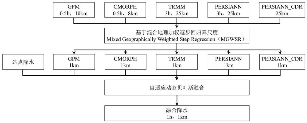
[0067] Such as figure 1 As shown, a kind of satellite ground multi-source precipitation self-adaptive dynamic fusion method provided by the present invention comprises the following steps:

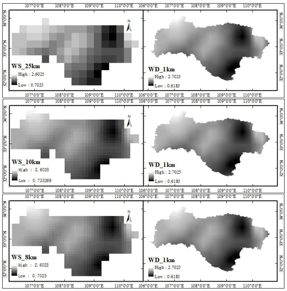
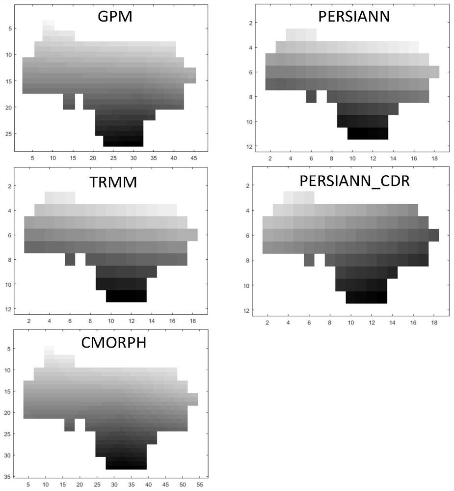
[0068] Step 1, obtain the time-invariant factors of the coarse resolution (Coarse Resolution, CR) and the fine resolution (Fine Resolution, FR) of the watershed, mainly including: DEM (DEM CR 、DEM FR ), slope (Slope CR 、Slope FR ), Hand Index (Hand CR 、Hand FR ), roughness (SR CR 、SR FR ); the time-varying factors of coarse resolution and fine resolution are: NDVI(NDVI CR 、NDVI FR ), wind speed (WS CR 、WS FR ), land surface temperature (LST CR 、LST FR ), scattering index (SI CR 、SI FR ), microwave polarization index (PD CR 、PD FR ); the satellite number is represented by m, m=1, 2, ..., 5 represent GPM, TRMM, CMORPH, PERSIANN, PERSIANN_CDR ...


PUM


Abstract

The invention discloses a satellite-ground multi-source rainfall adaptive dynamic fusion method. The method comprises the following steps: acquiring time-invariant factors and time-variant factors of coarse resolution and fine resolution of a watershed, wherein the time-invariant factors comprise DEM, the gradient, a Hand index and the roughness, and the time-varying factors comprise NDVI, a wind speed, a surface temperature, a scattering index and a microwave polarization index; downscaling each satellite to obtain fine resolution precipitation of each satellite; constructing an adaptive dynamic Bayesian framework, and calculating the optimal weight of each satellite in a grid where an actual measurement site is located through distribution conversion of precipitation errors and precipitation probability density function parameter optimization; and calculating the optimal weight of the fine-resolution grid of each satellite, and carrying out weighted summation on rainfall of the fine-resolution grid of each satellite to obtain fusion rainfall. According to the method, site precipitation and multi-satellite precipitation are fused through an adaptive dynamic fusion method, a fine-resolution fusion precipitation product is obtained, and data support is provided for input of a refined hydrological model.

Description

technical field [0001] The invention belongs to the technical field of hydrology and meteorology, and in particular relates to a method for realizing fusion of satellite-earth multi-source precipitation based on obtaining dynamic weights in time and space. Background technique [0002] China is a country with frequent flood disasters, and hydrological model is an important means to solve flood disasters. Precipitation is the most critical input source of hydrological models, and the accuracy and timeliness of precipitation directly affect the accuracy and reliability of simulation results. [0003] At present, the methods of obtaining precipitation data mainly include ground observation, satellite and radar quantitative precipitation estimation, and model quantitative precipitation forecasting. For a long time, the routine observation of precipitation has mainly relied on the observation stations deployed on the surface, and the limited observation results represent the rea...

Claims


Application Information

Patent Timeline
Patent Type & Authority Applications(China)
IPC IPC(8): G06F17/16G06N7/00G01W1/10
CPCG06F17/16G01W1/10G06N7/01G01W1/14
Inventor 张珂晁丽君刘林鑫
Owner HOHAI UNIV
Why Eureka
Try Eureka