Residential stock house tax basis price evaluation method and system based on GIS (Geographic Information System) grid data

A technology of price evaluation and grid data, which is applied in the field of real estate evaluation, can solve the problems of difficult data collection, high similarity requirements, and failure to meet the needs of real estate, so as to achieve visualization, eliminate unreliability, and improve intelligence and efficiency. Effect

Pending Publication Date: 2021-06-18
合肥德宽信息技术有限责任公司
View PDF0 Cites 4 Cited by
  • Summary
  • Abstract
  • Description
  • Claims
  • Application Information

AI Technical Summary

Problems solved by technology

At present, most collection agencies use methods such as market comparison method to evaluate houses. Because the market comparison method requires a high degree of similarity between comparable examples and the basic data of appraised houses, it is difficult to collect data and cannot meet all the requirements in the appraised area. Requirements for Fast and Accurate Property Appraisals

Method used


Image

  • Residential stock house tax basis price evaluation method and system based on GIS (Geographic Information System) grid data
  • Residential stock house tax basis price evaluation method and system based on GIS (Geographic Information System) grid data
  • Residential stock house tax basis price evaluation method and system based on GIS (Geographic Information System) grid data

Examples


Embodiment 1

[0056] In the residential housing inventory tax base price evaluation system based on GIS grid data proposed in this embodiment, the GIS map module is used to map the data in the GIS according to the administrative area boundary vector data, the land level area boundary vector data, and the school district boundary vector data, etc. The boundaries of administrative districts, land levels, and school districts are drawn on the map.

[0057] The GIS map module is also used to perform coordinate positioning on the GIS map of the acquired geographic location information of the cell. Combined with the existing technology, the operator only needs to mark the cell to the corresponding position in the GIS map according to the location of the cell, and the coordinate data is automatically generated.

[0058] The GIS map module is also used to mark on the GIS map the obtained community characteristics that affect the price of stock houses. For specific implementation, the characteristi...

Embodiment 2

[0062] In this embodiment, the administrative attributes include: administrative area, land and school district. In this embodiment, the GIS map module is used to mark each administrative attribute on the GIS map, as shown in Table 1 to Table 4 specifically.

[0063] Table 1: Data annotation format of administrative regions divided into districts and counties:

[0064] Numbering province city District / County boundary line coordinates

[0065] Table 2: Data label format divided into counties, districts and streets:

[0066] Numbering province city street / town street grade boundary line coordinates

[0067] Table 3: Data annotation format of land:

[0068] Numbering province city District / County land class name land level boundary line coordinates

[0069] Table 4: Data annotation format for school districts:

[0070]

[0071] The boundary line coordinates...


PUM


Abstract

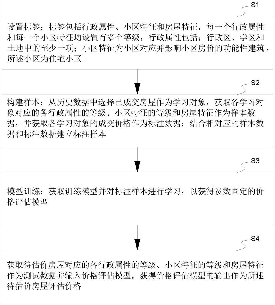
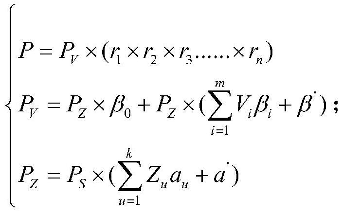
A residential stock house tax basis price evaluation method and system based on GIS grid data comprises: acquiring administrative attributes, community features and house features, wherein each administrative attribute and each community feature are provided with a plurality of grades; selecting a transacted house from the historical data as a learning object, obtaining the grade of each administrative attribute, the grade of the community feature and the house feature corresponding to each learning object as sample data, and obtaining the transaction price of each learning object as annotation data; establishing an annotation sample in combination with the corresponding sample data and annotation data; and obtaining a training model and learning the labeled sample to obtain a price evaluation model with fixed parameters. According to the method and system, layer-by-layer progressive evaluation of district prices, housing estate prices and house prices is realized through division of district grids, housing estates and houses, price balance estimation in the same division region is realized on the same division level, and then house price estimation is finally realized through further supplementary correction.

Description

technical field [0001] The invention relates to the technical field of real estate valuation, in particular to a method and system for evaluating the tax base price of residential stock housing based on GIS grid data. Background technique [0002] With the advancement of my country's real estate marketization, housing transactions are becoming more and more frequent. Active market transactions provide a broad source of taxation for housing transaction tax collection and management, and at the same time put forward newer and higher requirements for tax collection agencies. In order to prevent as much as possible the behavior of both parties to the transaction who evade taxes by underdeclaring the transaction price in order to reduce transaction costs, the collection agency must supervise the transaction declaration price through the verification of the taxable price and plug the loopholes in collection and management. At present, most collection agencies use methods such as m...

Claims


Application Information

Patent Timeline
IPC IPC(8): G06Q30/02G06Q40/00G06Q50/16G06F16/29
CPCG06Q30/0201G06Q30/0206G06Q30/0278G06Q50/16G06Q40/123G06F16/29
Inventor 黄伟宁仁祥赵志鹰王斌刘俊
Owner 合肥德宽信息技术有限责任公司
Why Eureka
Try Eureka