Plane feature fusion method in the process of slam mapping

A feature fusion and plane technology, applied in the field of image processing, can solve the problems of insufficient map simplicity and low map accuracy, and achieve the effects of reducing redundant features, improving simplicity, and improving accuracy.

Active Publication Date: 2022-06-03
CHONGQING UNIV
View PDF6 Cites 0 Cited by
  • Summary
  • Abstract
  • Description
  • Claims
  • Application Information

AI Technical Summary

Problems solved by technology

[0005] (1) The fused features still contain more redundant features, so the constructed map is not concise enough
[0006] (2) The existence of accumulated errors in the fusion process leads to low accuracy of the constructed map

Method used


Image

  • Plane feature fusion method in the process of slam mapping
  • Plane feature fusion method in the process of slam mapping
  • Plane feature fusion method in the process of slam mapping

Examples


Embodiment Construction

[0051] The embodiments of the present invention are described below through specific specific examples, and those skilled in the art can easily understand other advantages and effects of the present invention from the contents disclosed in this specification. The present invention can also be implemented or applied through other different specific embodiments, and various details in this specification can also be modified or changed based on different viewpoints and applications without departing from the spirit of the present invention. It should be noted that the drawings provided in the following embodiments are only used to illustrate the basic idea of ​​the present invention in a schematic manner, and the following embodiments and features in the embodiments can be combined with each other without conflict.

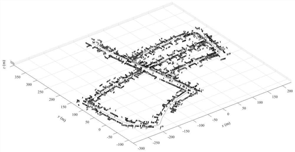
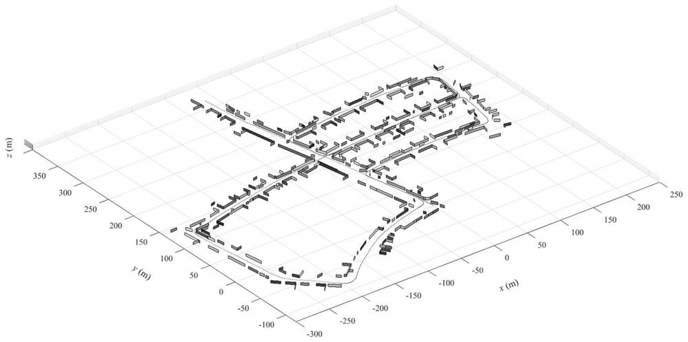
[0052] Among them, the accompanying drawings are only used for exemplary description, and represent only schematic diagrams, not physical drawings, and should not be ...


PUM


Abstract

The invention relates to a plane feature fusion method in the process of SLAM mapping, belonging to the field of image processing. The steps are: 1) According to the point cloud data of the vehicle lidar, segment the plane features in the lidar coordinate system at different times; 2) Obtain the vehicle GPS position and IMU heading angle information at different continuous times, so as to obtain the translation matrix relative to the initial position and rotation matrix; 3) Transform all plane feature information in the lidar coordinate system to the world coordinate system; 4) Angle size for the intersection line between any plane feature and the x‑o‑y plane at any two different times The calculation of the calculation of the coincidence degree of the feature circle and the calculation of the relative distance; 5) Delete the class with a small number of features in the class, and find the corresponding linear regression equation for the features of the remaining classes, and then construct the world coordinate system. global map. The invention reduces redundant features, improves the simplicity of map expression and the precision of map construction.

Description

technical field [0001] The invention belongs to the field of image processing, and relates to a plane feature fusion method in a SLAM mapping process. Background technique [0002] Vehicle-mounted lidar can accurately perceive the surrounding environment of the vehicle and has the advantages of fast response and long ranging. Structured buildings are common obstacles in urban traffic environments. How to construct a map corresponding to a building from a 3D point cloud is one of the important issues for vehicles to perceive the environment. In general, planar features can represent the surface of a structured building in the real environment, but the same building surface is likely to be repeated in multiple consecutive frames, eventually resulting in redundant features in the planar feature map. These redundant features should be properly fused to avoid ambiguity in map representation and reduce computation. [0003] The existing plane feature fusion methods mainly inclu...

Claims


Application Information

Patent Timeline
Patent Type & Authority Patents(China)
IPC IPC(8): G06T7/10G06T3/00G06F16/29G01S17/89G01S17/931G01S19/47G01C21/16
CPCG06T7/10G06T3/0012G06F16/29G01S17/89G01S17/931G01S19/47G01C21/165G06T2207/10044G06T2207/20221G06T2207/10012G06T2207/30252
Inventor 李飞亚傅春耘孙冬野胡明辉
Owner CHONGQING UNIV
Why Eureka
Try Eureka