Supercharge Your Innovation With Domain-Expert AI Agents!

Grid map optimization method, storage medium and mobile robot

A grid map and optimization method technology, which is applied to instruments, image analysis, image data processing, etc., can solve problems such as inaccurate positioning, unsightly grid maps, and difficulties in beautifying grid maps, and achieve the effect of improving accuracy.

Pending Publication Date: 2021-07-02
PUPPY ELECTRONICS APPLIANCES INTERNET TECH (BEIJING) CO LTD
View PDF11 Cites 0 Cited by
  • Summary
  • Abstract
  • Description
  • Claims
  • Application Information

AI Technical Summary

Problems solved by technology

[0003] However, in the process of mapping, since the sweeping machine needs to continuously process the laser and perform mapping, and the error of the sensor becomes larger and larger with the increase of time and movement, it will cause the raster map constructed during the mapping process to be incomplete. The thickness of the wall is getting bigger and bigger, and the positioning based on the grid map will become more and more inaccurate, and the error will become bigger and bigger; in addition, the thickness of the wall will also make the grid map look unattractive, and the grid map Map beautification will cause relatively large difficulties
[0004] In the existing technology, in many cases, the cumulative error cannot be avoided by not building a map at all, because in the actual environment, the environment itself will continue to change due to various factors, and preventing the construction of the grid map will cause more serious problem

Method used


Image

  • Grid map optimization method, storage medium and mobile robot
  • Grid map optimization method, storage medium and mobile robot
  • Grid map optimization method, storage medium and mobile robot

Examples


Embodiment 1

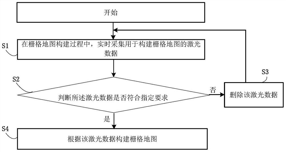
[0064] In order to solve the above-mentioned technical problems existing in the prior art, an embodiment of the present invention provides a grid map optimization method.

[0065] refer to figure 1 , the raster map optimization method of the present embodiment, comprises the following steps:

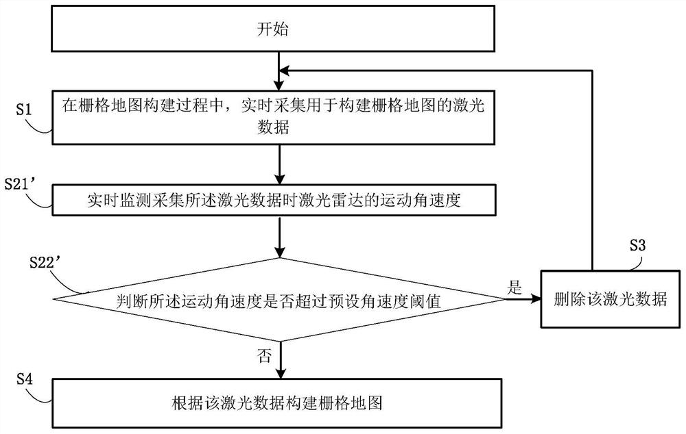
[0066] S1, during the construction of the grid map, real-time collection of laser data for the construction of the grid map;

[0067] In this embodiment, the grid map is constructed through the following steps:

[0068] The laser radar of the mobile robot is used to collect the environmental information within the viewing angle, and the synchronous positioning and map construction algorithm is used to process the environmental information to construct a pre-constructed grid map.

[0069] S2, judging whether the laser data meets specified requirements:

[0070] If not, execute step S3;

[0071] If yes, execute step S4;

[0072] S3, delete the laser data, and return to step S1;

[0...

Embodiment 2

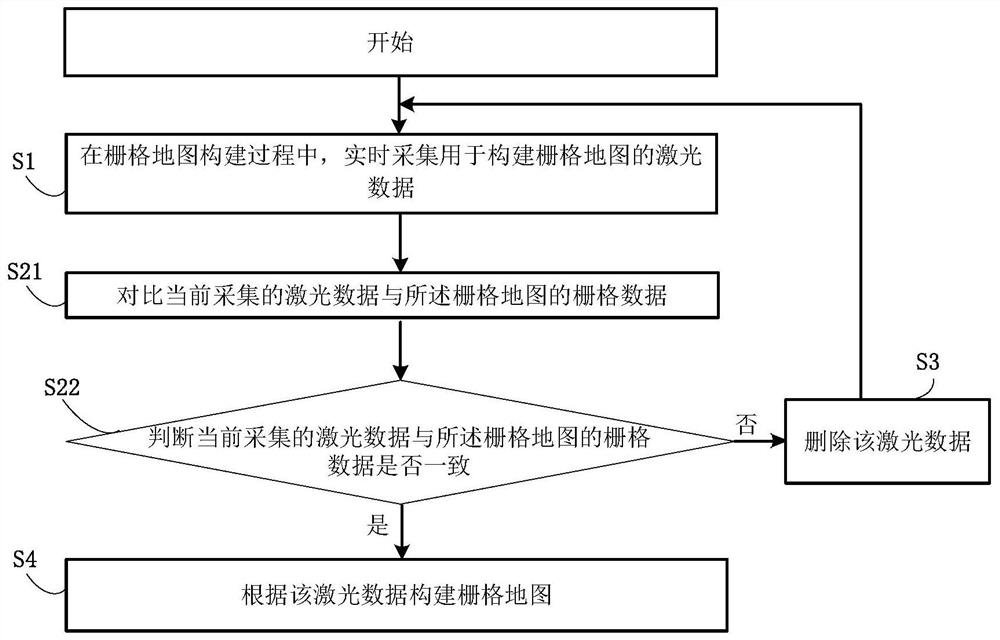
[0076] In order to solve the above-mentioned technical problems existing in the prior art, the embodiment of the present invention provides a grid map optimization method based on the first embodiment, wherein, the grid map optimization method in the embodiment of the present invention performs step S2 in the first embodiment Improve.

[0077] refer to figure 2 , the raster map optimization method of the present embodiment, comprises the following steps:

[0078] S1, during the construction of the grid map, real-time collection of laser data for the construction of the grid map;

[0079] S21, comparing the currently collected laser data with the grid data of the grid map;

[0080] S22, judging whether the currently collected laser data is consistent with the grid data of the grid map:

[0081] If not, execute step S3;

[0082] If yes, execute step S4;

[0083] S3, delete the laser data, and return to step S1;

[0084] S4, constructing a grid map according to the laser d...

Embodiment 3

[0127]In order to solve the above-mentioned technical problems existing in the prior art, an embodiment of the present invention provides a grid map optimization method based on Embodiment 2, wherein the grid map optimization method of the embodiment of the present invention is applied to a sweeper.

[0128] The raster map optimization method of this embodiment includes the following steps:

[0129] The first step is to start building the map when the sweeper starts (under no special circumstances, the sweeper is stationary or going straight, and there will be no rotation), and the first frame of laser is mapped on the map;

[0130] In the second step, starting from the second frame (if the laser is frequency-reduced, it will be the next frame after the frequency reduction), for the new hit position constructed by each beam of laser on the grid map, judge Whether the hit position already exists on the grid map before the new hit position in the laser propagation direction:

...


PUM


Abstract

The invention discloses a grid map optimization method, a storage medium and a mobile robot. The method comprises the steps of collecting laser data for constructing a grid map in real time in the grid map construction process; judging whether the laser data meet specified requirements or not, specifically, deleting the laser data when the laser data do not meet the specified requirements, and returning to the step of collecting the laser data for constructing the grid map in real time; and when the laser data meet the specified requirements, constructing the grid map according to the laser data. The accuracy of the grid map can be improved by eliminating map constructing errors in the construction process of the grid map, and the positioning accuracy can be improved when the grid map is used for positioning.

Description

technical field [0001] The invention belongs to the technical field of synchronous positioning and map construction application, and in particular relates to a grid map optimization method, a storage medium and a mobile robot. Background technique [0002] The core algorithm modules of mobile robots, especially sweeping robots, include map positioning and path planning. Path planning strictly depends on positioning and map building. Therefore, the accuracy of positioning and map building is very important, which fundamentally determines the Intelligence level. At present, the positioning and construction of commercial sweeping robots Figure 1 Generally, the lidar sensor is used as the sensor for external information input. The lidar signal directly returns the distance to the target according to the real-time return, making mapping and positioning more efficient. [0003] However, in the process of mapping, since the sweeping machine needs to continuously process the laser...

Claims


Application Information

Patent Timeline
Patent Type & Authority Applications(China)
IPC IPC(8): G05D1/02G01C21/00G06F16/29G06T7/187G06T7/70
CPCG05D1/0214G05D1/0257G05D1/0274G01C21/005G06F16/29G06T7/70G06T7/187
Inventor 檀冲王颖李文治孟庆业张振奎侯双
Owner PUPPY ELECTRONICS APPLIANCES INTERNET TECH (BEIJING) CO LTD
Features
  • R&D
  • Intellectual Property
  • Life Sciences
  • Materials
  • Tech Scout
  • Unparalleled Data Quality
  • Higher Quality Content
  • 60% Fewer Hallucinations
Learn More