Tree identification method and device

A recognition method and tree technology, applied in character and pattern recognition, image analysis, image enhancement, etc., can solve problems such as high price, small measurement range, and inconspicuous tree height characteristics, and achieve the effect of improving efficiency

Inactive Publication Date: 2021-07-13
CHONGQING UNIV
View PDF4 Cites 2 Cited by
  • Summary
  • Abstract
  • Description
  • Claims
  • Application Information

AI Technical Summary

Problems solved by technology

[0004] However, when the related technologies identify trees, they must be identified under the premise of high precision, and the measurement range is not large and the price is expensive.
Satellite remote sensing images have the characteristics of wide coverage and low price. However, when only two-dimensional satellite images are used, the recognition rate of individual trees is low due to the low resolution of the images and the inconspicuous characteristics of tree heights.

Method used


Image

  • Tree identification method and device
  • Tree identification method and device
  • Tree identification method and device

Examples


Embodiment Construction

[0030] In order to make the purpose, technical solution and advantages of the present application clearer, the implementation manners of the present application will be further described in detail below in conjunction with the accompanying drawings.

[0031] First, a brief introduction to the nouns involved in the embodiments of this application:

[0032] A digital terrain model (Digital Terrain Model, DTM) is an analog representation of a continuous ground using a large number of known x, y, and z coordinate points selected in an arbitrary coordinate system. In other words, DTM is the terrain surface morphological attribute information The digital expression of is a digital description with spatial location features and terrain attribute features. x and y represent the plane coordinates of the point, and the z value can represent information such as elevation, slope, temperature, etc. When z represents the elevation, it is a digital elevation model (Digital Elevation Model, D...


PUM


Abstract

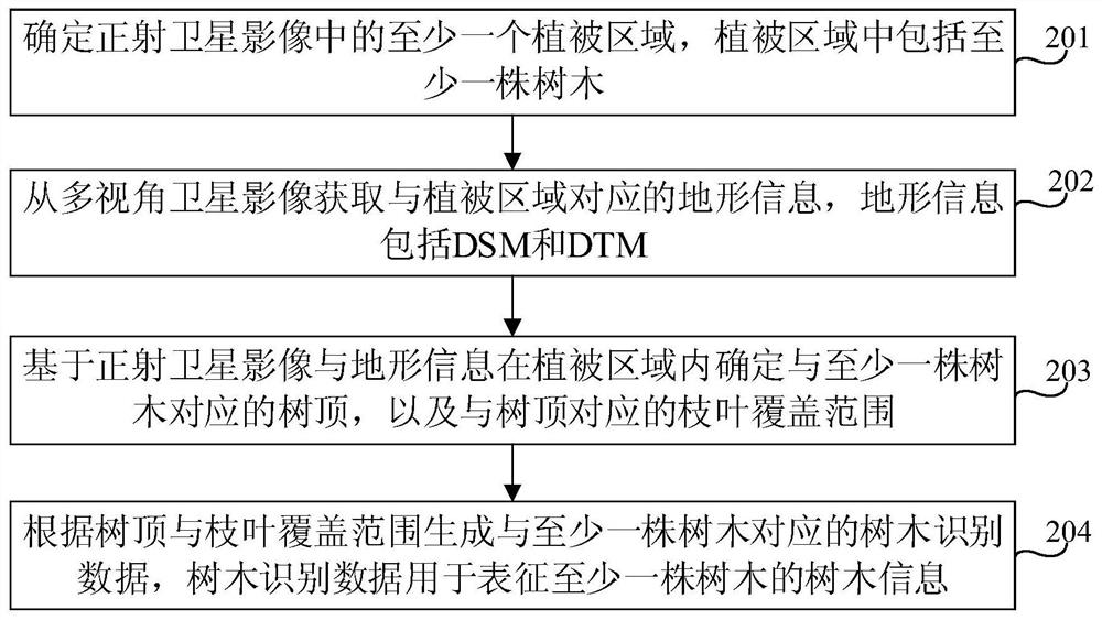
The invention relates to a tree identification method and device, and relates to the technical field of forestry. The method comprises the following steps: determining at least one vegetation area in an orthographic satellite image; obtaining topographic information corresponding to the vegetation area from the multi-view satellite image; determining a tree top corresponding to at least one tree and a branch and leaf coverage range corresponding to the tree top in the vegetation area based on the orthographic satellite image and the topographic information; and generating tree identification data corresponding to at least one tree according to the tree top and branch and leaf coverage area, wherein the tree identification data represents tree information of the at least one tree. After a multi-view satellite image and an orthographic satellite image are obtained from a satellite image set, the coverage range of a tree top and branches and leaves is determined in a vegetation area based on topographic information, and then tree information in the vegetation area is obtained. The tree position is determined and the corresponding tree information is generated through the combination of the topographic data and the satellite image, so that the efficiency of identifying the tree is improved.

Description

technical field [0001] The present application relates to the technical field of forestry, in particular to a tree identification method and device. Background technique [0002] Composed of trees, forests are one of the important components of the land surface and play an important role in the global ecosystem, therefore, timely and accurate measurement of forest parameters such as tree number, tree height at the level of individual trees and leaf cover size are critical for quantitative analysis of forest structure, ecological modeling, biomass estimation and deforestation assessment. [0003] Among related technologies, methods based on lidar or photogrammetry of three-dimensional feature points usually use a standardized digital surface model (normalize digital surface model, nDSM) or a canopy height model (Canopy HeightModel) to directly determine the position of trees with high accuracy. Highlights tree tops and provides tree-related parameters. [0004] However, whe...

Claims


Application Information

Patent Timeline
Patent Type & Authority Applications(China)
IPC IPC(8): G06K9/00G06K9/46G06T7/11G06T17/00G06T17/05
CPCG06T17/05G06T17/00G06T7/11G06T2207/10032G06T2207/20116G06T2207/20132G06V20/188G06V10/44
Inventor 肖长林洪竞科
Owner CHONGQING UNIV
Why Eureka
Try Eureka