Unmanned aerial vehicle flight path planning method in concave polygon area based on remote sensing task

A concave polygon, track planning technology, applied in three-dimensional position/channel control, instruments, control/regulation systems, etc., can solve the problem of simple algorithm, unsuitable for remote sensing tasks, and unsupported UAV track planning for multiple sorties, etc. problems, to achieve significant effects and meet the needs of remote sensing tasks

Active Publication Date: 2021-08-06
PEKING UNIV
View PDF4 Cites 7 Cited by
  • Summary
  • Abstract
  • Description
  • Claims
  • Application Information

AI Technical Summary

Problems solved by technology

[0005] In view of the above defects, the technical problem to be solved by the present invention is to provide a UAV track planning based on remote sensing tasks in a concave polygon area, so as to solve the problems existing in the current technology that cannot be applied to remote sensing tasks, and the algorithm is simple and ideal. The problem of not supporting the trajectory planning of multiple sorties of drones

Method used


Image

  • Unmanned aerial vehicle flight path planning method in concave polygon area based on remote sensing task
  • Unmanned aerial vehicle flight path planning method in concave polygon area based on remote sensing task
  • Unmanned aerial vehicle flight path planning method in concave polygon area based on remote sensing task

Examples


Embodiment Construction

[0056] The following will clearly and completely describe the technical solutions in the embodiments of the present invention with reference to the accompanying drawings in the embodiments of the present invention. Obviously, the described embodiments are only some, not all, embodiments of the present invention. Based on the embodiments of the present invention, all other embodiments obtained by persons of ordinary skill in the art without making creative efforts belong to the protection scope of the present invention.

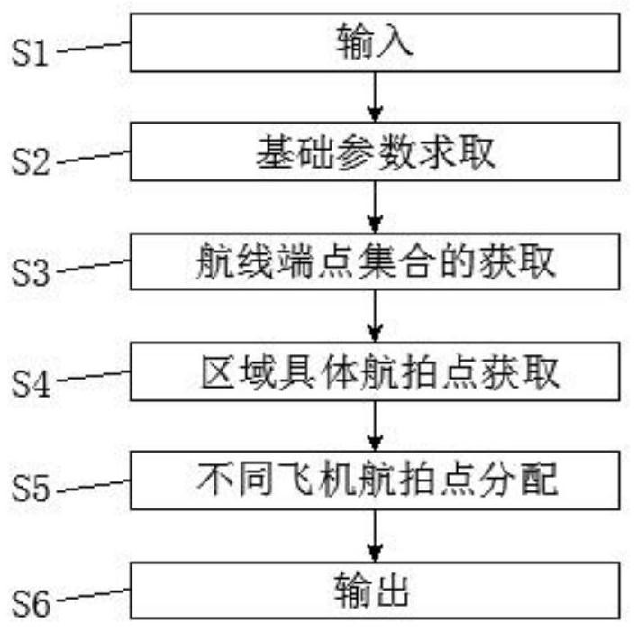
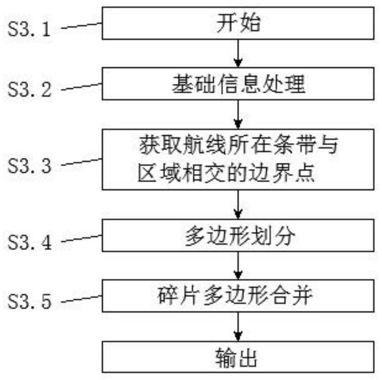
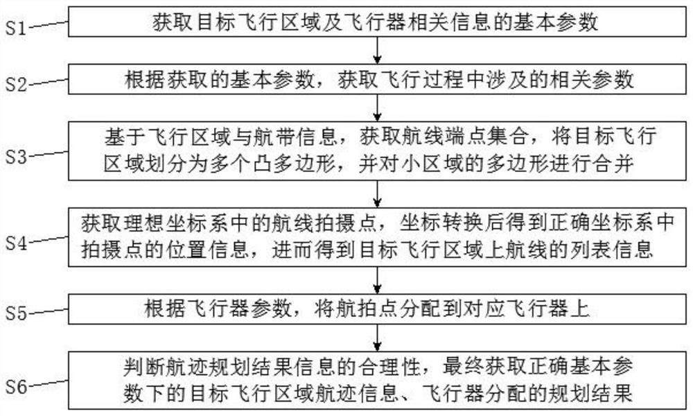
[0057] Please also refer to Figure 1 to Figure 6 Now, a specific implementation of UAV track planning based on remote sensing tasks in concave polygonal areas provided by the present invention will be described. The specific steps of this remote sensing mission-based UAV track planning in a concave polygon area include:

[0058] S1, obtain the basic parameters of the target flight area and aircraft related information, wherein the basic parameters include th...


PUM


Abstract

The invention discloses a concave polygon area unmanned aerial vehicle flight path planning method based on a remote sensing task, and the method carries out the flight path planning of multiple unmanned aerial vehicles according to the specific remote sensing task mapping demand, gives the specific aerial photography point information, and guarantees the shortest total flight under the condition of guaranteeing the full coverage of an observation area. According to the concave polygon area unmanned aerial vehicle flight path planning based on the remote sensing task, on the basis of flight path planning (multiple loads, multiple aircrafts, an actual geographical base map, course overlapping degree, lateral overlapping degree, resolution and the like) of the remote sensing task, acquisition of aerial photography points corresponding to the geographical base map and the flight path planning is considered, the requirement of the remote sensing task can be met, and the method is more practical. According to the method, shooting of aerial images in the flight process of the unmanned aerial vehicle and later image splicing are considered, the action effect is remarkable, and the method is suitable for wide popularization.

Description

technical field [0001] The present invention relates to the technical field of track planning, in particular to a track planning for a UAV in a concave polygon area based on a remote sensing task. Background technique [0002] Existing UAV trajectory planning has many different application scenarios. Many UAV trajectory planning algorithms currently proposed do not consider the particularity of remote sensing tasks, but only consider it from the perspective of UAV flight. They use the turning radius of the drone to calculate the distance between the drone's flight belts, and this algorithm cannot be applied to remote sensing tasks. [0003] At present, most of the algorithms for UAV track planning are considered in the category of convex polygons. There are also a few people who have studied the track planning of concave polygons. Most of them consider using the scan line method as the basic algorithm. However, the existing algorithm is relatively simple, which belongs to t...

Claims


Application Information

Patent Timeline
Patent Type & Authority Applications(China)
IPC IPC(8): G05D1/10
CPCG05D1/106
Inventor 刘旭林赵红颖程印乾李芹
Owner PEKING UNIV
Why Eureka
Try Eureka