Remote sensing image multi-label classification method based on adjacent matrix guide label embedding

An adjacency matrix and remote sensing image technology, applied in the field of image processing, can solve the problems of inability to associate multi-label and remote sensing image learning, lack of prior information of label feature vectors, affecting classification accuracy, etc., to eliminate difficult to characterize label dependencies, reduce Influence and increase the effect of mF1 value

Active Publication Date: 2021-08-06
XIDIAN UNIV
View PDF6 Cites 4 Cited by
  • Summary
  • Abstract
  • Description
  • Claims
  • Application Information

AI Technical Summary

Problems solved by technology

However, its shortcomings are: since this method only considers the corresponding relationship between the label and the image block, ignoring the implicit label dependency in the data, the obtained label feature vector lacks the guidance of prior information. In addition, , this method cannot perform pixel-level association learning on multi-label and remote sensing images, which affects the further improvement of classification accuracy

Method used


Image

  • Remote sensing image multi-label classification method based on adjacent matrix guide label embedding
  • Remote sensing image multi-label classification method based on adjacent matrix guide label embedding
  • Remote sensing image multi-label classification method based on adjacent matrix guide label embedding

Examples


Embodiment Construction

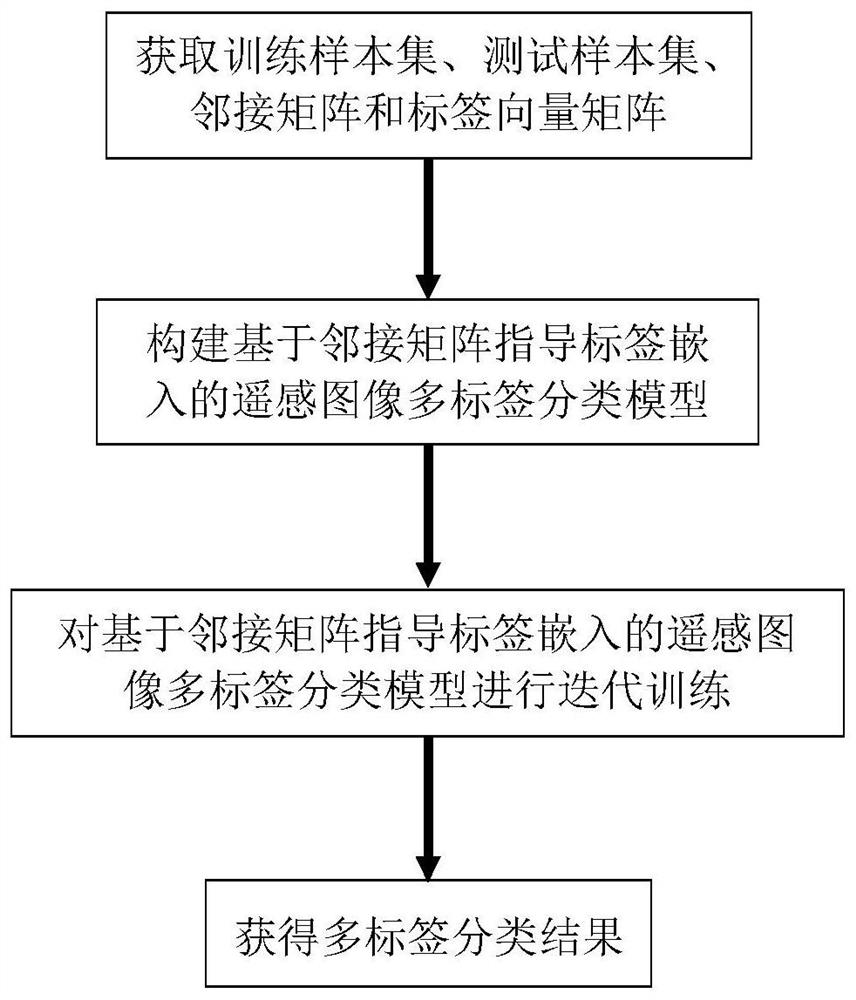
[0040] The present invention will be further described in detail below in conjunction with the accompanying drawings and specific embodiments.

[0041] refer to figure 1 , the present invention includes the following steps.

[0042] Step 1) Obtain training sample set, test sample set, adjacency matrix and label vector matrix:

[0043] (1a) Obtain S pieces of optical remote sensing images containing C target categories X={X s |1≤s≤S}, each optical remote sensing image X s Contains at least one target category Each target category is included in P optical remote sensing images, where S≥100, C≥2, X s Indicates the sth optical remote sensing image, P≥2, , means X s contains the lth target category, , means X s does not contain the l-th target category. Wherein, S=2100, C=17.

[0044] (1b) For each optical remote sensing image X s Label the included targets to get a multi-label set L={L l |0≤l≤C-1}, and subtract the image mean value in the ImageNet dataset from each ...


PUM


Abstract

The invention provides a remote sensing image multi-label classification method based on adjacency matrix guide label embedding. The method comprises the following steps: obtaining a training sample set, a test sample set, an adjacency matrix and a label vector matrix; constructing a remote sensing image multi-label classification model based on adjacent matrix guidance label embedding; iteratively training the remote sensing image multi-label classification model based on adjacent matrix guidance label embedding; and obtaining a multi-label image classification result. The label vector matrix embedding process is constrained through the minimum mean square error loss of the adjacent matrix and the embedded vector cosine similarity matrix, the prior information of the adjacent matrix is fully considered, and the mF1 value of multi-label image classification is improved; by introducing a label and image collaborative embedding method, joint modeling is performed on a response relationship between a label and each pixel in a feature map, so that the influence of a remote sensing image background on multi-label image classification is reduced, and the mF1 value of multi-label image classification is further improved.

Description

technical field [0001] The invention belongs to the technical field of image processing, and relates to an image multi-label classification method, in particular to a remote sensing image multi-label classification method based on an adjacency matrix guiding label embedding, which can be used for urban mapping, scene understanding and image retrieval. Background technique [0002] Remote sensing images are images that are scanned and captured by high-altitude sensors on the ground surface. They have excellent characteristics such as all-weather, wide viewing angle, and less occlusion, and have been widely used in military, civilian and other fields. According to the number of target categories in remote sensing images, remote sensing images can be divided into single-label remote sensing images and multi-label remote sensing images. If a single remote sensing image contains one or more target categories, it is called a multi-label remote sensing image. Multi-label classific...

Claims


Application Information

Patent Timeline
Patent Type & Authority Applications(China)
IPC IPC(8): G06K9/62G06N3/04G06N3/08
CPCG06N3/08G06N3/045G06F18/214G06F18/24
Inventor 张向荣单守平
Owner XIDIAN UNIV
Why Eureka
Try Eureka