Automatic navigation system and method used in scenes such as parks and communities

An automatic navigation and scene technology, applied in the control/adjustment system, two-dimensional position/channel control, non-electric variable control and other directions, which can solve the problems of infeasible automatic navigation function, inability to meet popularization, easy to demagnetize, etc.

Pending Publication Date: 2021-08-27
郭全安
View PDF0 Cites 0 Cited by
  • Summary
  • Abstract
  • Description
  • Claims
  • Application Information

AI Technical Summary

Problems solved by technology

This navigation technology cannot be used outdoors. On the one hand, because the outdoor distance is longer, the cost of magnetic track navigation will be extremely high. On the other hand, the magnetic track is not easy to maintain outdoors, and it is easy to degauss or be damaged. Therefore, this solution is used to realize outdoor scenes such as parks. Autopilot is not available
In addition, if the unmanned navigation technology used by cars on the road is used, although accurate arbitrary path navigation can be realized, its technical realization needs to rely on various high-precision real-time positioning systems such as real-time satellite positioning and inertial navigation, which will make smart mobile devices The manufacturing cost has been greatly increased, which cannot meet the popularization in public places such as parks.

Method used


Image

  • Automatic navigation system and method used in scenes such as parks and communities

Examples


Embodiment Construction

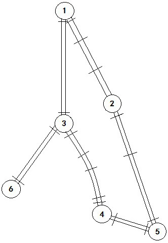
[0011] Taking a certain park as an example, it is first necessary to determine the target points and driving roads to be served according to the needs, and then carry out unified route planning according to the actual road conditions. suppose figure 1 It is the path map of the park after planning. Among them, by adding inflection point 2, the road between inflection point 1 and inflection point 5 is divided into two straight paths, namely path 1-2 and path 1-5 (note: path 1-2 refers to the path from inflection point 1 to inflection point 2, and the path 2-3 refers to the path from inflection point 2 to inflection point 3, and so on).

[0012] Secondly, on-site survey is required to accurately measure the direction and length of each path, and digitally form the electronic information map database with this information. Among them, for the special path between inflection point 3 and inflection point 4, it is necessary to use smart mobile devices to conduct round-trip driving ...


PUM


Abstract

According to the method, roads and target points in scenes such as parks, scenic spots and communities are reasonably planned and accurately measured in advance, the roads are divided into a path network composed of most of linear paths and a small number of special paths, and the navigation for the linear paths is simplified into linear navigation in the path direction; a small number of special paths adopt a pre-verified navigation instruction as a main mode and adopt a mode of finely adjusting and correcting the advancing direction of equipment through video real-time road boundary identification and a method of pre-embedding a group of electronic tags at a key path position as an auxiliary mode to realize automatic navigation. Therefore, the dependence of the intelligent mobile device on a real-time high-precision positioning system during automatic navigation is avoided, and the navigation cost of the intelligent mobile device is greatly reduced.

Description

technical field [0001] With the advancement of artificial intelligence technology, various service-oriented intelligent mobile devices (such as robots) are gradually applied in restaurants, hospitals, shopping malls and other public places. At present, they mainly realize voice consultation, meal delivery, food delivery and other service functions. However, the use of smart mobile devices to provide related services in outdoor scenes such as parks, scenic spots, and residential areas has not been popularized. The main reason is that it is limited by the current automatic navigation technology of smart mobile devices. Traditional indoor navigation methods are not suitable for outdoor use. And the self-driving technology used in cars is expensive and cannot be popularized. Background technique [0002] The current navigation method commonly used by food delivery robots used in restaurants is magnetic navigation. The robot moves along the magnetic strip, and is directly above i...

Claims


Application Information

Patent Timeline
IPC IPC(8): G05D1/02
CPCG05D1/0221G05D1/0246G05D1/0276
Inventor 郭全安
Owner 郭全安
Why Eureka
Try Eureka