Real-time identification system and method for crops based on unmanned aerial vehicle

A technology of identification system and identification method, applied in the field of real-time identification system of crops based on UAV, can solve the problems of low identification accuracy of crop types, different heights of trees, uneven distribution of field sizes, etc., to improve efficiency and informatization The level of technology, the effect of improving work efficiency and accuracy, and promoting sustainable agricultural development

Active Publication Date: 2021-08-31
NANTONG UNIVERSITY
View PDF6 Cites 3 Cited by
  • Summary
  • Abstract
  • Description
  • Claims
  • Application Information

AI Technical Summary

Problems solved by technology

[0004]2. Uncertainty of remote sensing data: remote sensing data is easily interfered by external factors such as weather, atmosphere, electromagnetic, etc., and the resolution is low, which leads to the uncertainty of remote sensing image classification High uncertainty of results and low accuracy of crop type identification
[0005]3. The field operation environment is complex: In the actual agricultural situation survey, there are scattered rural buildings, intricate wires, trees of different heights, and river networks in the operation of drones. Density, une

Method used


Image

  • Real-time identification system and method for crops based on unmanned aerial vehicle
  • Real-time identification system and method for crops based on unmanned aerial vehicle
  • Real-time identification system and method for crops based on unmanned aerial vehicle

Examples


Embodiment 1

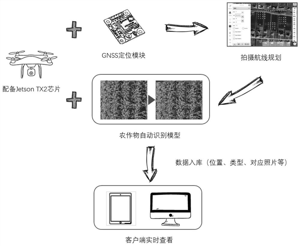
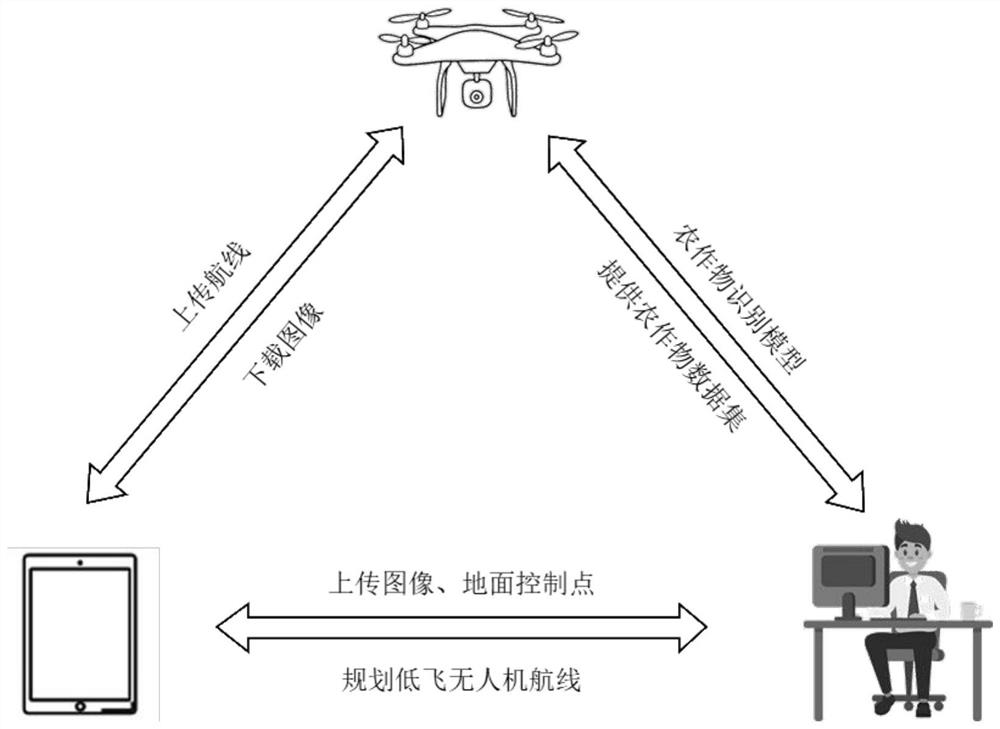
[0042] See figure 1 with figure 2 This embodiment provides an engine-based crop real-time recognition system, including: drone platform, route planning module, crop recognition module, server and mobile terminal, an image acquisition device and crop recognition on a drone platform Module, the route planning module is set in the server, the drone platform, the route planning module, the crop recognition module, the server, and the mobile terminal can communicate with each other.

[0043] The image acquisition device is for continuous image acquisition to the survey area, acquires the first image and the second image of the area to be investigated, and transmits the first image and the second image to the server, crop recognition module, and mobile terminal, wherein When an image is in an air of the drone platform, the image acquisition device is acquired by the image acquisition device, the second image is an image acquisition device when the drone platform is at 15M to 20m from th...

Embodiment 2

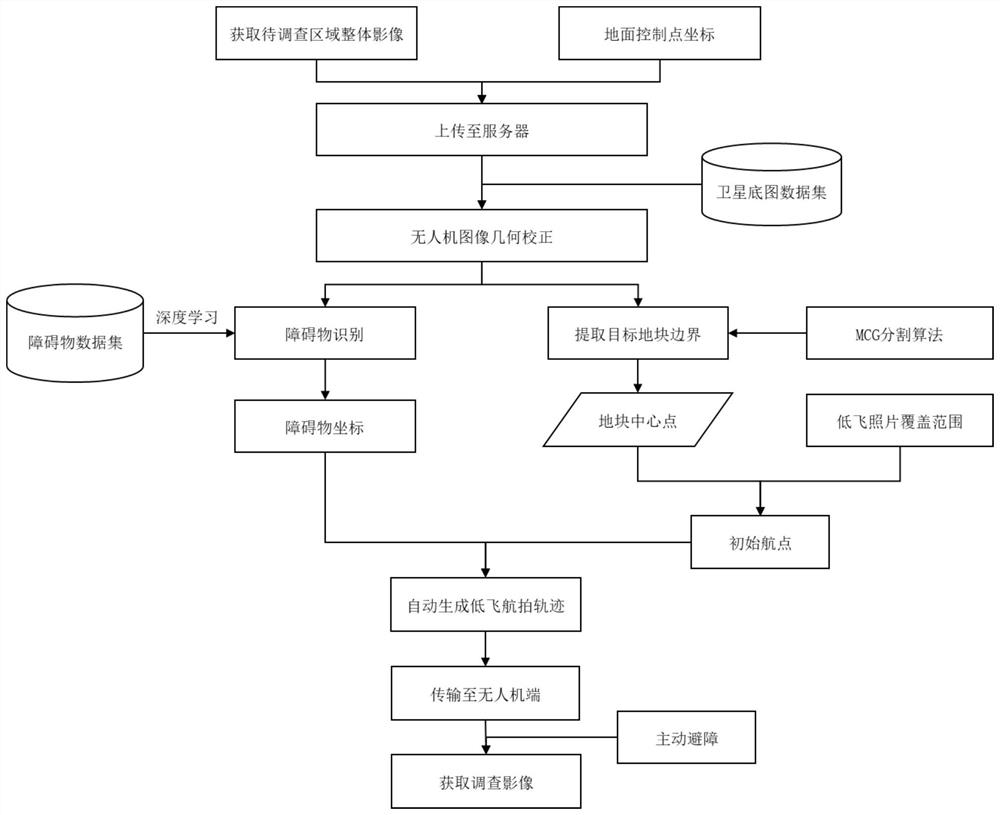
[0060] See Figure 3 - Figure 5 This embodiment provides a real-time recognition method based on an officer-based crop, including the steps of:

[0061] Step S1, according to the survey range and the actual situation, the drone platform is flying to 100m to 500m, and the image acquisition device to be investigated is obtained by the image acquisition device on the drone platform, and the area of ​​the survey is obtained through the GNSS handset. Ground control point coordinate information, and the first image and the corresponding ground control point coordinate information are uploaded to the server;

[0062] Step S2, the industry personnel download the first image and the corresponding ground control point coordinate information, and performs geometric correction processing, which has the corresponding set coordinate information to obtain a geometric correction image;

[0063] Step S3, the image input after the registration obtained in step S2 is used to identify the YOLOV3 obsta...


PUM


Abstract

The invention discloses a real-time identification system for crops based on an unmanned aerial vehicle. The system comprises an unmanned aerial vehicle platform, a route planning module, a crop identification module, a server and a mobile terminal, wherein the unmanned aerial vehicle platform is provided with an image acquisition device and the crop identification module, and the route planning module is arranged in the server. The invention further discloses a real-time identification method for crops based on the unmanned aerial vehicle. According to the method, after the server plans the route of the unmanned aerial vehicle, the route is uploaded to the mobile terminal, and the unmanned aerial vehicle can execute crop image collection and real-time crop identification tasks after receiving an instruction, and upload the obtained crop image and a final identification result to an agricultural condition database. The crop identification module is realized based on a crop identification model trained by YOLOv3.

Description

Technical field [0001] The present invention relates to crop survey, monitoring technology, and more particularly, to a UAV based on real-time identification of the system and method of crops. Background technique [0002] Throughout ancient and modern, is the agriculture of our country was founded on, play a vital role in my country's economic development. In recent years, domestic and foreign scholars in the use of remote sensing technology to identify the type of crops of some progress, and most of the time sequence of remote sensing and crop phenological characteristics combine to achieve crop classification. Driven by the rapid development of my country's agricultural modernization, "precision agriculture" concept has penetrated into all aspects of agricultural production. UAV its operational flexibility, high resolution advantages, has become an important tool for gathering information on precision agriculture, particularly crops are widely used classification, the nature o...

Claims


Application Information

Patent Timeline
IPC IPC(8): G05D1/10
CPCG05D1/101
Inventor 张慧芳王彬窈汤中港宜树华
Owner NANTONG UNIVERSITY
Why Eureka
Try Eureka