Supercharge Your Innovation With Domain-Expert AI Agents!

Unmanned aerial vehicle cluster autonomous cooperation system and method based on photoelectric navigation

A collaborative system and UAV technology, applied in the field of UAV navigation, can solve problems such as weak GPS signal UAV, GPS signal easily interfered, UAV cannot return smoothly, etc., to achieve the effect of synchronous avoidance

Active Publication Date: 2021-09-07
西安爱生无人机技术有限公司
View PDF3 Cites 0 Cited by
  • Summary
  • Abstract
  • Description
  • Claims
  • Application Information

AI Technical Summary

Problems solved by technology

[0003] For the sake of safety, many drones are equipped with GPS navigation, so that if the remote control cannot be controlled, the drone can navigate back according to the pre-loaded map, but the GPS signal is easily interfered in the mountains. In this way, the UAV cannot return smoothly, or the GPS signal is weak, so that the UAV cannot avoid obstacles in time during the return process.

Method used


Image

  • Unmanned aerial vehicle cluster autonomous cooperation system and method based on photoelectric navigation
  • Unmanned aerial vehicle cluster autonomous cooperation system and method based on photoelectric navigation
  • Unmanned aerial vehicle cluster autonomous cooperation system and method based on photoelectric navigation

Examples


Embodiment Construction

[0051] The following will clearly and completely describe the technical solutions in the embodiments of the present invention with reference to the accompanying drawings in the embodiments of the present invention. Obviously, the described embodiments are only some, not all, embodiments of the present invention. Based on the embodiments of the present invention, all other embodiments obtained by persons of ordinary skill in the art without making creative efforts belong to the protection scope of the present invention.

[0052] see Figure 1-Figure 3 As shown, the present invention provides a kind of technical scheme:

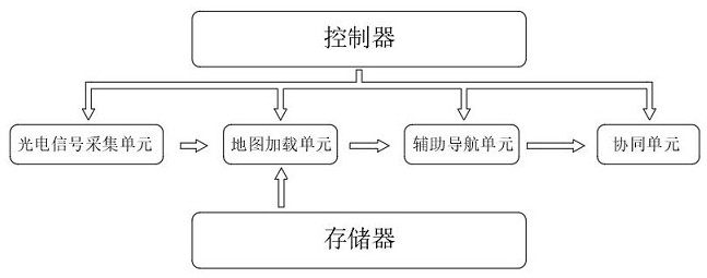
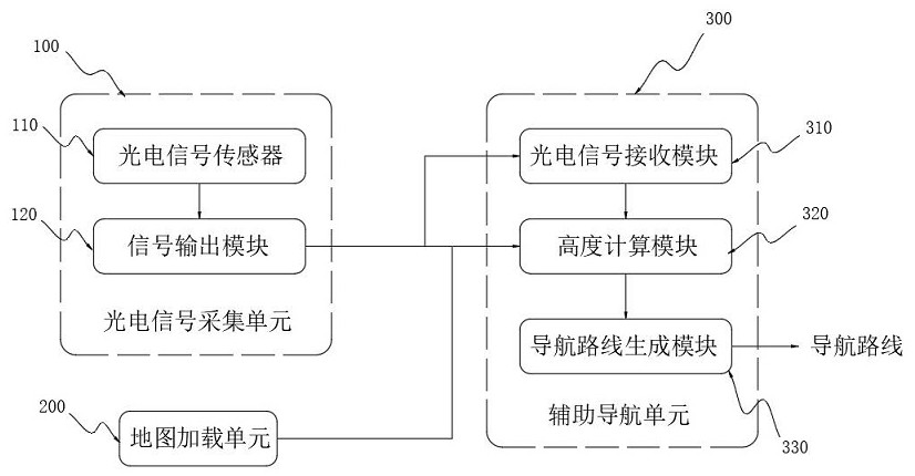
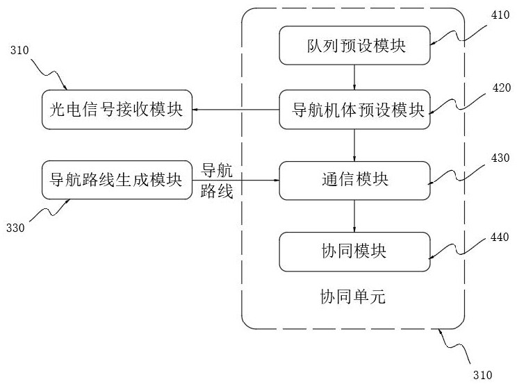
[0053]The present invention provides an autonomous coordination system for UAV clusters based on photoelectric navigation, including a photoelectric signal acquisition unit 100, a map loading unit 200, an auxiliary navigation unit 300, a coordination unit 400, a controller 500, and a memory 600; the photoelectric signal acquisition unit 100 Used to collect ref...


PUM


Abstract

The invention relates to the technical field of unmanned aerial vehicle navigation, in particular to an unmanned aerial vehicle cluster autonomous cooperation system and method based on photoelectric navigation. The system comprises a photoelectric signal acquisition unit, a map loading unit, an auxiliary navigation unit, a cooperation unit, a controller and a memory. According to the invention, the arranged photoelectric signal sensor emits and receives light beams, then the photoelectric signal receiving module receives photoelectric signals generated by the light beams, the height calculation module is combined to accurately calculate the distance between the unmanned aerial vehicle and an obstacle, and timely adjustment is carried out according to the distance, so that the obstacle is avoided in time; the problem that the unmanned aerial vehicles cannot be accurately controlled when no GPS signal exists or the signal is weak is solved, in addition, synchronization of unmanned aerial vehicle cluster signals is carried out through the cooperation unit, and therefore synchronous avoidance of the multiple unmanned aerial vehicles is achieved.

Description

technical field [0001] The invention relates to the technical field of unmanned aerial vehicle navigation, in particular to an autonomous coordination system and method for unmanned aerial vehicle clusters based on photoelectric navigation. Background technique [0002] Nowadays, drones are not only used in the military industry, but also in agriculture and photography. Generally, drones used in these two industries are controlled by remote controls, but whether they are used in agriculture or Photography has higher and higher requirements for UAVs, for example: irrigation of rice fields in the mountains or shooting of mountains and rivers in agriculture, so in these two cases the requirements for UAV evasion will be It is getting higher and higher, and sometimes multiple drones are required to form a cluster to work synchronously. [0003] For the sake of safety, many drones are equipped with GPS navigation, so that if the remote control cannot be controlled, the drone can...

Claims


Application Information

Patent Timeline
IPC IPC(8): G05D1/10
CPCG05D1/104Y02P90/02
Inventor 曹正阳唐炜吴亚龙李大健吴建军张明王水
Owner 西安爱生无人机技术有限公司
Features
  • R&D
  • Intellectual Property
  • Life Sciences
  • Materials
  • Tech Scout
  • Unparalleled Data Quality
  • Higher Quality Content
  • 60% Fewer Hallucinations
Learn More