
A land use recognition method for open-pit mines based on improved deeplabv3+

A technology of mining land and identification method, applied in the fields of deep learning semantic segmentation and remote sensing image processing, can solve problems such as high-precision extraction of unfavorable open-pit mines, large pixel ratio difference, loss of detailed information, etc., to speed up network operation, improve Segmentation accuracy, the effect of suppressing interference information

Active Publication Date: 2022-06-17
CHINA UNIV OF MINING & TECH (BEIJING) +1
View PDF0 Cites 0 Cited by
  • Summary
  • Abstract
  • Description
  • Claims
  • Application Information

AI Technical Summary

Problems solved by technology

[0004] However, applying the DeepLabV3+ network to the semantic segmentation of land use in open-pit mines faces three problems: 1) The codec structure restores image detail information, but the process of down-sampling still loses a lot of detailed information, which is not conducive to the classification of different land types in open-pit mines. High-precision extraction; 2) Although spatial pyramid pooling with different expansion rates is used to capture multi-scale context information, it still lacks the ability to utilize global context information, thus limiting the effect of semantic segmentation; 3) Different types of land use in open-pit mine scenarios The proportion of pixels between them is quite different. If the same weight is used to directly train the network, it will make the network tend to classify the category with a small area into a category with a large proportion.

Method used


Image

  • A land use recognition method for open-pit mines based on improved deeplabv3+
  • A land use recognition method for open-pit mines based on improved deeplabv3+
  • A land use recognition method for open-pit mines based on improved deeplabv3+

Examples


Embodiment

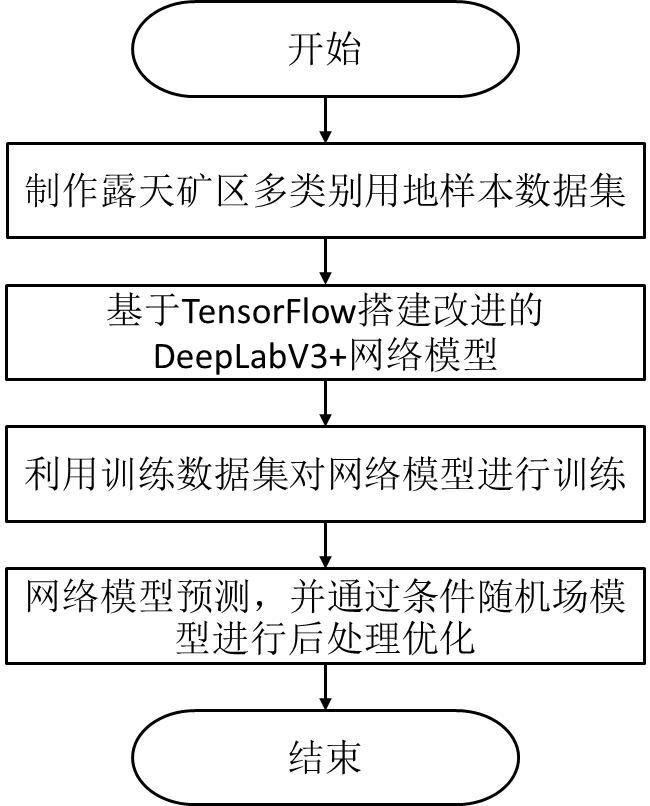
[0053] like Figure 1 to Figure 4 As shown, a land use identification method based on improved DeepLabV3+ in open-pit mining area, the method is as follows:

[0054] A. Create a multi-category land sample data set in an open-pit mining area:

[0055] A1. Collect remote sensing image data of open-pit mining areas and mark them. The marked objects include open-pit mining areas, coal areas, dumps, and reclamation areas;

[0056] A2. Cut the remote sensing image data of the open-pit mining area into image blocks of 500×500 (500×500 can be divided according to the pixel size or size, which is determined according to the size of the remote sensing image data of the open-pit mining area and the effective data range), and the image The blocks are randomly divided into training data and test data, all training data are collected into training data sets and stored, and all test data are collected into test data sets and stored;

[0057] A3. Perform data enhancement processing on the t...


PUM


Abstract

The invention discloses an improved DeepLabV3+-based land use recognition method for open-pit mining areas. Firstly, sample data sets of different land use types in the mining area are produced, a DeepLabV3+ network model is constructed, and Xception is used as the basic network architecture to extract low-level and high-level features. Pyramid pooling extracts multi-scale feature information, and then inputs multi-scale features into the attention mechanism module to enhance the classification ability of the network model; finally, aggregates Xception low-level features and multi-scale high-level features, and obtains model predictions through convolution and upsampling result. The present invention reduces the edge information loss caused by layer-by-layer convolution pooling of the network through the multi-scale spatial information fusion of low-level features, and improves the segmentation accuracy. By introducing a spatial attention mechanism module to aggregate multi-scale context information, the classification ability of the network model is enhanced. Through The proportional weighting method solves the problem of sample imbalance in network training and improves the classification and recognition accuracy of various types of land use.

Description

technical field [0001] The invention relates to the fields of remote sensing image processing and deep learning semantic segmentation, in particular to a method for identifying land use in open-pit mining areas based on improved DeepLabV3+. Background technique [0002] The mining of open-pit mines has brought a series of ecological problems. The dynamic monitoring and statistics of open-pit mines are of great significance to the regional ecological environment protection. Therefore, realizing the efficient and accurate identification of different land types in open-pit mines is one of the problems to be solved urgently. The traditional land-use identification and extraction is obtained through field surveys or manual delineation of images. With the rapid development of remote sensing technology, people can obtain a large amount of high-resolution remote sensing earth observation data, so that the automatic classification method based on high-resolution image data gradually ...

Claims


Application Information

Patent Timeline
Patent Type & Authority Patents(China)
IPC IPC(8): G06V20/13G06V10/80G06V10/774G06V10/40G06V10/764G06V10/82G06K9/62G06N3/04G06N3/08
CPCG06N3/08G06N3/045G06F18/241G06F18/253G06F18/214
Inventor 李军杜守航杨金中张成业邢江河郑慧玉李炜
Owner CHINA UNIV OF MINING & TECH (BEIJING)
Learn More