
A multi-source satellite remote sensing image mosaic method, system and storage medium

A satellite remote sensing image and remote sensing image technology, applied in the field of remote sensing image, can solve the problems of incomplete coverage information and small scope of the target area, achieve the effect of enriching spatial information and spectral characteristics, and solving the problem of insufficient data volume

Active Publication Date: 2022-04-29
WUHAN OPTICS VALLEY INFORMATION TECH
View PDF8 Cites 0 Cited by
  • Summary
  • Abstract
  • Description
  • Claims
  • Application Information

AI Technical Summary

Problems solved by technology

[0003] In the actual application of high-quality remote sensing images, due to the influence of many factors such as shooting range, revisit cycle, color, weather, and time, for a single satellite data source, the area of ​​the research area is large or small , but there are some clouds, mountains or vegetation shadows in the captured images, which will lead to incomplete coverage information of the target area

Method used


Image

  • A multi-source satellite remote sensing image mosaic method, system and storage medium
  • A multi-source satellite remote sensing image mosaic method, system and storage medium
  • A multi-source satellite remote sensing image mosaic method, system and storage medium

Examples


Embodiment Construction

[0028] The specific implementation manners of the present invention will be further described in detail below in conjunction with the accompanying drawings and embodiments. The following examples are used to illustrate the present invention, but are not intended to limit the scope of the present invention.

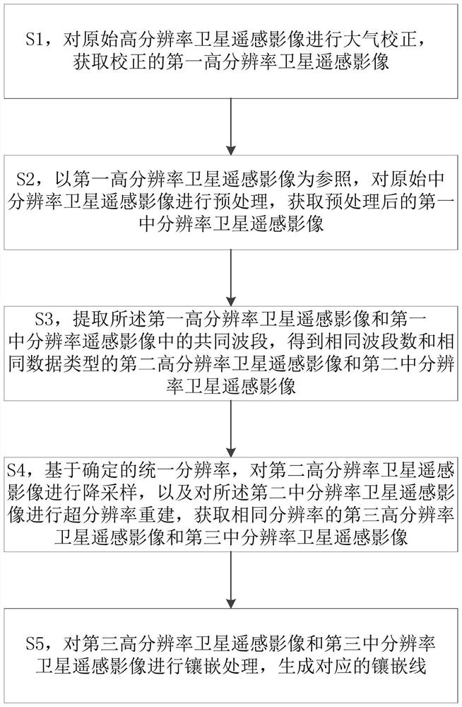
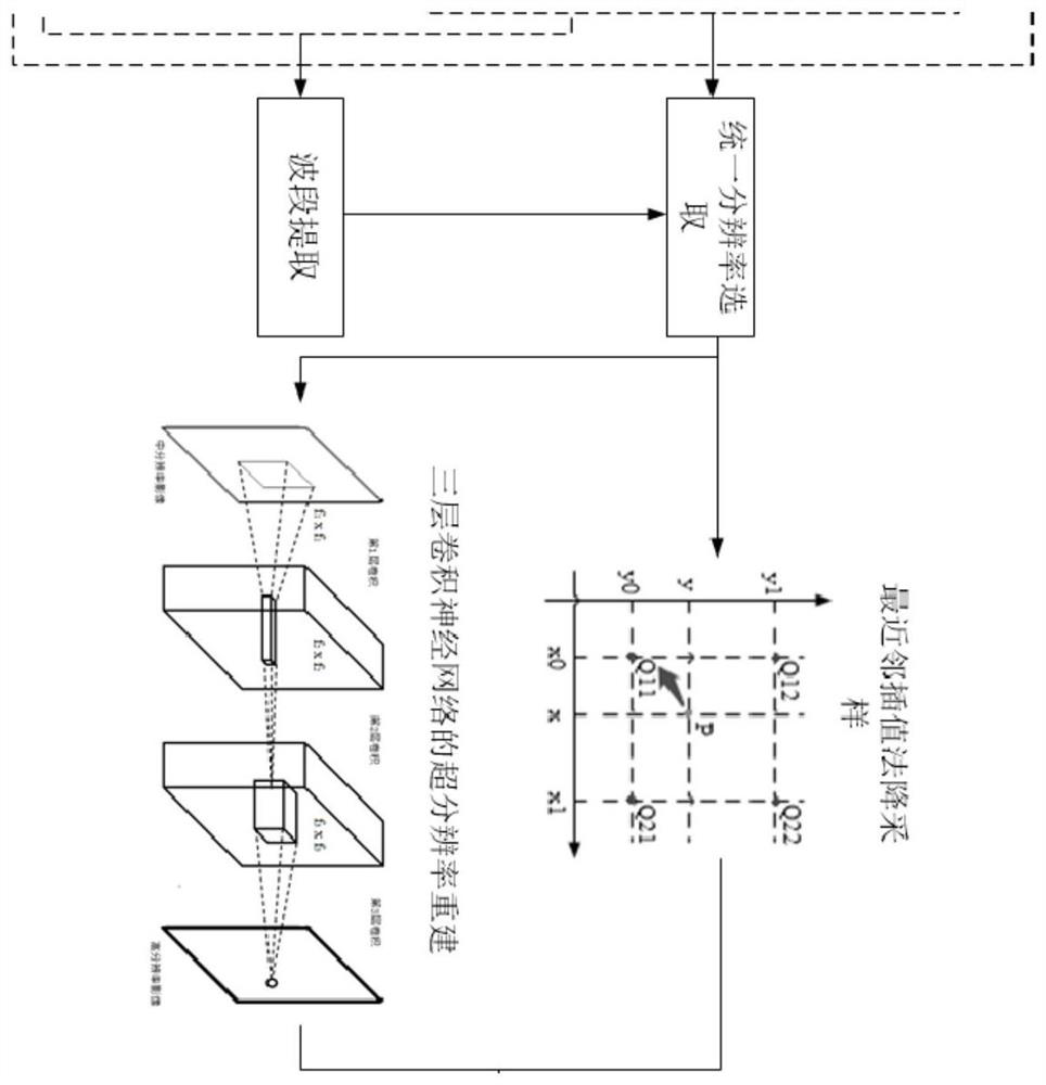
[0029] figure 1 A flow chart of a multi-source satellite remote sensing image mosaic method provided by an embodiment of the present invention, as shown in figure 1As shown, the method includes: S1, performing atmospheric correction on the original high-resolution satellite remote sensing image, and obtaining the corrected first high-resolution satellite remote sensing image; S2, using the first high-resolution satellite remote sensing image as a reference, Preprocessing the original medium-resolution satellite remote sensing image to obtain a preprocessed first medium-resolution satellite remote sensing image; S3, extracting the first medium-resolution satellite remote s...


PUM


Abstract

The invention provides a multi-source satellite remote sensing image mosaic method, system and storage medium, respectively preprocessing the original high-resolution satellite remote sensing image and the original medium-resolution satellite remote sensing image, extracting the high-resolution satellite remote sensing image and the medium-resolution image The common band of satellite remote sensing images, as well as down-sampling of high-resolution satellite remote sensing images and super-resolution reconstruction of medium-resolution satellite remote sensing images, the resolution of the two is unified, and finally the same resolution of high-resolution Satellite remote sensing images and medium resolution satellite remote sensing images are mosaiced to generate mosaic lines to identify targets in the images. The present invention combines down-sampling and super-resolution reconstruction technologies to mosaic multi-source satellite remote sensing images, which not only retains the rich spatial information and spectral characteristics of high-resolution satellite images to a certain extent, but also uses medium-resolution satellite images as data supplements to solve the problem. Solved the problem of insufficient data volume of high-resolution images in industrial applications.

Description

technical field [0001] The present invention relates to the field of remote sensing images, and more specifically, to a multi-source satellite remote sensing image mosaic method, system and storage medium. Background technique [0002] With the continuous development of space information technology, a variety of satellite sensors with high resolution, hyperspectral, and multi-temporal phases have been launched one after another. In order to further promote the development of remote sensing technology and apply it to land and natural resources, crop growth, disaster monitoring, and environmental changes Possibilities are offered in areas such as monitoring and water conservancy. How to achieve high-quality and in-depth comprehensive application of satellite remote sensing images with multiple spectral and spatial resolutions, and maximize the acquisition of rich spatial, spectral, texture and other feature information contained in various data sources is one of the research f...

Claims


Application Information

Patent Timeline
Patent Type & Authority Patents(China)
IPC IPC(8): G06T3/40G06V20/13G06V10/44G06V10/82G06N3/04G06N3/08
CPCG06T3/4053G06T3/4007G06N3/08G06N3/045
Inventor 吴燕平姜益民罗冷坤杜庭晖
Owner WUHAN OPTICS VALLEY INFORMATION TECH
Learn More