Land cover classification method based on deep fusion of multi-modal remote sensing data

A technology of remote sensing data and land surface coverage, applied in the field of remote sensing, can solve problems such as more exploration in the field of depth feature fusion, and achieve the effect of broad application prospects

Pending Publication Date: 2021-10-01
上海中科辰新卫星技术有限公司
View PDF0 Cites 17 Cited by
  • Summary
  • Abstract
  • Description
  • Claims
  • Application Information

AI Technical Summary

Problems solved by technology

However, none of the existing methods has done more exploration in the field of deep feature fusion. For example, the densely connected transformation network (DCST) uses the transformer as a feature extractor to try to replace the encoder structure in the classic convolutional network. ; For example, U-shaped network-based transformation network (TransUNet) regards transformer as a high-dimensional feature ex

Method used


Image

  • Land cover classification method based on deep fusion of multi-modal remote sensing data
  • Land cover classification method based on deep fusion of multi-modal remote sensing data
  • Land cover classification method based on deep fusion of multi-modal remote sensing data

Examples


Embodiment Construction

[0052] The present invention will be further described below in combination with specific embodiments. It should be understood that these examples are only used to illustrate the present invention and are not intended to limit the scope of the present invention. In addition, it should be understood that after reading the content taught by the present invention, those skilled in the art may make various changes or modifications to the present invention, and these equivalent forms also fall within the scope defined by the appended claims of the present application.

[0053] A land cover classification method based on deep fusion of multimodal remote sensing data, the steps are as follows:

[0054] (1) Build a model;

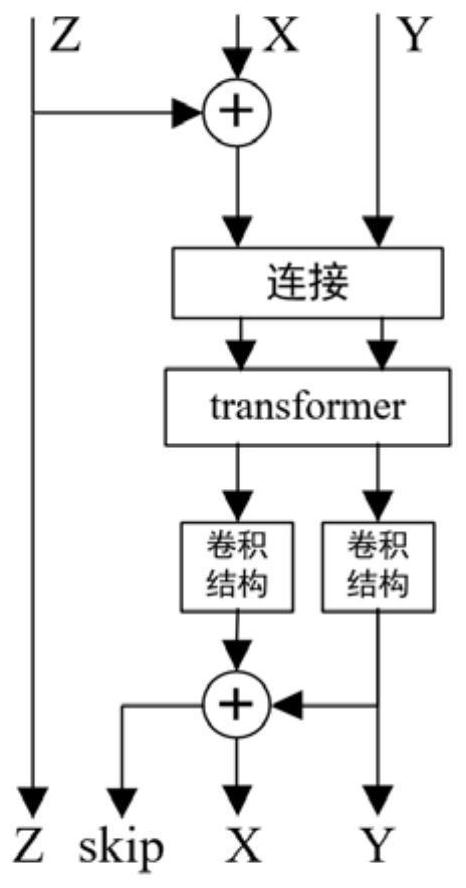
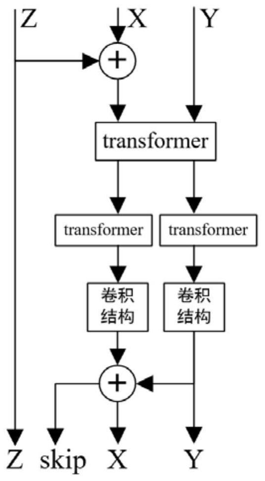
[0055] The model is a remote sensing image semantic segmentation network based on multimodal information fusion. The model structure is as follows: figure 1 As shown, it includes an encoder for extracting feature features, a deep feature fusion module, a spatial ...


PUM


Abstract

The invention relates to a land cover classification method based on deep fusion of multi-modal remote sensing data. The method comprises the following steps: (1) constructing a remote sensing image semantic segmentation network based on multi-modal information fusion, wherein the network comprises an encoder for extracting ground feature features, a depth feature fusion module, a spatial pyramid module and an up-sampling decoder, and the depth feature fusion module comprises an ACF3 module and a CACF3 module which are used for simultaneously fusing three modal information of RGB, DSM and NDVI, the ACF3 module is a self-attention convolution fusion module based on transformer and convolution, and the CACF3 module is a cross-modal convolution fusion module based on transformer and convolution; (2) training the network constructed in the step (1); (3) utilizing the network model trained in the step (2) to predict the remote sensing image ground object category. Compared with a conventional method, the earth surface coverage classification method based on multi-modal remote sensing data deep fusion has the advantages that the precision improvement effect on earth surface classification tasks is remarkable, and the application prospect is wide.

Description

technical field [0001] The invention belongs to the technical field of remote sensing, and relates to a land cover classification method based on deep fusion of multimodal remote sensing data. Background technique [0002] The classification of surface objects (ground objects) is an important basis for the application of remote sensing image analysis. Nowadays, the continuous observation of the surface by multiple sensors has given birth to multi-scale, multi-temporal, multi-azimuth, and multi-level surface remote sensing images, which provide richer data information for the accurate description of ground objects. Since it is essentially the observation of the same ground object, although there is a certain gap between different modal information, there is still a complementary characteristic of information between multi-source remote sensing images. Therefore, using multiple remote sensing information sources to classify ground objects can achieve higher accuracy than sing...

Claims


Application Information

Patent Timeline
IPC IPC(8): G06K9/00G06K9/34G06K9/62G06N3/04
CPCG06N3/045G06F18/253
Inventor 曹金文枚金杨庆楠苏含坤
Owner 上海中科辰新卫星技术有限公司
Why Eureka
Try Eureka