Large-scale refined landform digital simulation method and device

A large-scale, landform technology, applied in the field of data processing, can solve problems such as large deviations, and achieve the effect of improving rationality and accuracy

Pending Publication Date: 2021-10-19
CHINA REINSURANCE (GROUP) CORPORATION +1
View PDF0 Cites 0 Cited by
  • Summary
  • Abstract
  • Description
  • Claims
  • Application Information

AI Technical Summary

Problems solved by technology

However, the existing mainstream typhoon models generally calculate the standard landform, and its characteristic roughness length is Z0 = 0.03 meters. For the research objects with dense coastal cities, the standard landform assumption will cause large deviations

Method used


Image

  • Large-scale refined landform digital simulation method and device
  • Large-scale refined landform digital simulation method and device
  • Large-scale refined landform digital simulation method and device

Examples


Embodiment Construction

[0026] The technical features of different embodiments of the present invention can be combined arbitrarily in accordance with the gist of the present invention, therefore, any specific embodiment should not be construed as limiting the protection scope of the present invention.

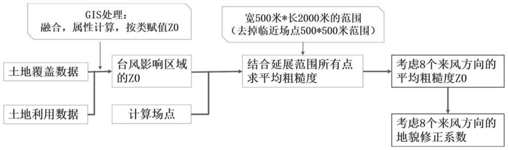
[0027] The method for large-scale and refined landform digital simulation in some embodiments includes the following steps:

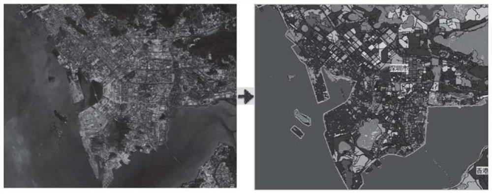
[0028] Perform GIS grid processing on the land cover data LU and / or land use data LC, extract the actual surface object cover type of each grid as the type of LU and or LC, and assign corresponding values ​​to each grid according to the corresponding type Roughness length, to obtain land grid data;

[0029] Obtain the grid corresponding to the area affected by any typhoon and calculate each site point of the typhoon;

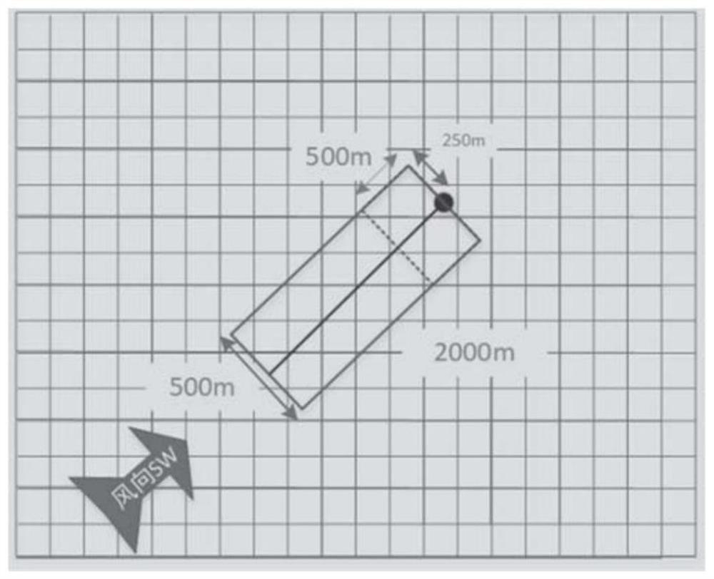
[0030] Determining at least one extension range in at least one wind direction and vertical wind direction with the site point as a reference position;

[003...


PUM


Abstract

The invention relates to a large-scale refined landform digital simulation method, which is characterized by comprising the following steps of: carrying out GIS (Geographic Information System) gridding on land coverage data LU and/or land utilization data LC, and assigning a value ZO to each grid according to roughness length classification to obtain land gridding data; obtaining a grid corresponding to any typhoon influence area, and calculating each field point of the typhoon; determining at least one extension range in at least one wind coming direction and a vertical wind direction by taking the field point as a reference position; according to the land gridding data included in at least one extension range, calculating the average roughness length of all points in the extension range as the average roughness length ZO of the center point of the large-scale refined terrain grid; according to the average roughness length ZO, assigning values to the roughness lengths corresponding to the grids of the typhoon wind field model according to landform classification; and giving a landform correction coefficient according to the landform type obtained according to the average roughness length. The invention provides a large-scale refined landform digital simulation method so as to reflect landform changes in a typhoon wind field model.

Description

technical field [0001] The present invention belongs to the technical field of data processing, and in particular relates to a method and device for large-scale fine landform digital simulation, which can be used for wind disasters, rainfall and flood simulations and loss assessments caused by typhoons in large-scale spatial ranges (such as the whole of China or the world) and other fields. Background technique [0002] At present, the parametric wind field model is mainly used in the simulation of the ocean wind field, and the consideration of the complex underlying surface in the land area is still insufficient, especially the impact of landform changes on the typhoon wind field. When the typhoon is on the ocean surface, the underlying surface is a smooth water surface. At this time, the underlying surface can be simplified as superimposing the roughness produced by waves on a plane with an altitude of zero. The existing parametric wind field models do not take landform c...

Claims


Application Information

Patent Timeline
IPC IPC(8): G06T17/05
CPCG06T17/05Y02A90/10
Inventor 熊政辉方平治王小东宫婷岳溪柳
Owner CHINA REINSURANCE (GROUP) CORPORATION
Why Eureka
Try Eureka