Deep learning-based stationary orbit meteorological satellite radar reflectivity factor inversion method

A radar reflection, geostationary orbit technology, applied in neural learning methods, reflection/re-radiation of radio waves, computer systems based on knowledge-based patterns, etc. and other problems, to achieve the effect of shortening the time interval, strong nonlinear reconstruction, and high inversion accuracy

Pending Publication Date: 2021-10-22
NAT SATELLITE METEOROLOGICAL CENT
View PDF0 Cites 7 Cited by
  • Summary
  • Abstract
  • Description
  • Claims
  • Application Information

AI Technical Summary

Problems solved by technology

[0004] The existing technology uses geostationary meteorological satellite early warning products (or integrates numerical forecast model data) to detect s

Method used


Image

  • Deep learning-based stationary orbit meteorological satellite radar reflectivity factor inversion method
  • Deep learning-based stationary orbit meteorological satellite radar reflectivity factor inversion method
  • Deep learning-based stationary orbit meteorological satellite radar reflectivity factor inversion method

Examples


Embodiment 1

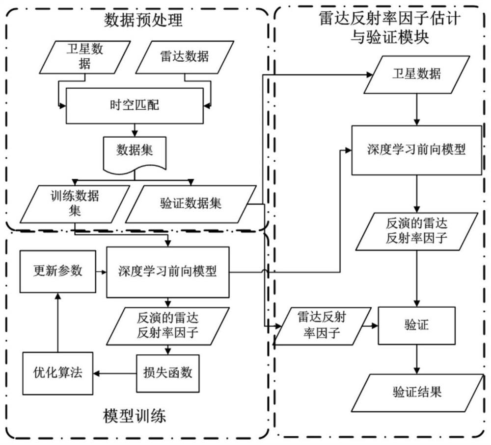
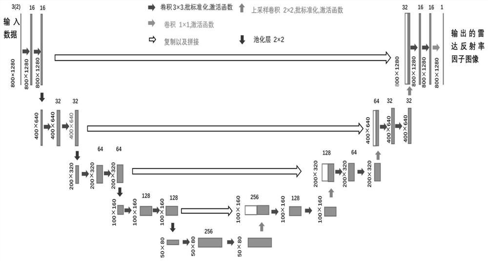
[0046] Such as figure 1 As shown, Embodiment 1 of the present invention proposes a method for inversion of geostationary satellite radar reflectivity factors based on deep learning. The invention is mainly composed of two modules, namely the preprocessing and training module on the left side of the block diagram and the verification module of the inventive technology shown on the right side of the block diagram.

[0047] 1. Data preparation

[0048] Firstly, the random forest method is used innovatively to select the channel with strong correlation with the radar reflectivity factor as the input of the model for the new generation geostationary orbit meteorological satellite imager data. On the one hand, it reduces the calculation and storage pressure, and on the other hand, it also clarifies the physical relationship between the radar reflectivity factor and the input. The radar reflectivity factor is closely related to the microphysical properties of clouds and the distrib...

Embodiment 2

[0068] Embodiment 2 of the present invention proposes a radar reflectivity factor inversion system for geostationary meteorological satellites based on deep learning. The system includes: a radar reflectivity factor inversion model, a sensitivity channel selection module, and an inversion result output module; the specific processing method is the same as in embodiment 1, wherein,

[0069] The sensitive channel selection module is used to select the sensitive channel of the geostationary meteorological satellite imager according to the random forest method; the sensitive channel is a channel with a strong correlation with the radar reflectivity factor;

[0070] The inversion result output module is used to receive the sensitive channel data transmitted by the imager of the geostationary meteorological satellite, input the pre-established and trained radar reflectivity factor inversion model, and obtain the inversion result.


PUM


Abstract

The invention relates to the technical field of severe convection weather early warning, in particular to a deep learning-based stationary orbit meteorological satellite radar reflectivity factor inversion method. The method comprises the following steps: selecting a sensitive channel of a geostationary orbit meteorological satellite imager according to a random forest method, wherein the sensitive channel is a channel with strong correlation with a radar reflectivity factor; and receiving sensitive channel data downloaded by the geostationary orbit meteorological satellite imager, and inputting the sensitive channel data into the pre-established and trained radar reflectivity factor inversion model to obtain an inversion result. According to the method, basic detection and diagnosis data are provided for disastrous weather in a radar uncovered area, and the beneficial effects of a severe convection system incompletely covered by radar data and typhoon cyclone strength distribution can be intuitively understood; therefore, the time interval can be shortened, and monitoring of a convection system which develops rapidly is facilitated; besides, the method has higher nonlinear reconstruction capability and higher inversion precision.

Description

technical field [0001] The invention relates to the technical field of strong convective weather early warning, in particular to a deep learning-based inversion method for geostationary meteorological satellite radar reflectivity factors. Background technique [0002] Disastrous weather often shows the natural characteristics of high intensity, strong destructiveness, wide distribution, rapid development and evolution, and great destructive power, which has attracted widespread attention. Quickly and effectively responding to disastrous weather events such as strong winds, heavy rainfall, and mountain torrents is of great significance to reducing the threat to the safety of people's lives and property. The key to forecasting these sudden disaster weather systems is timely observation, which has high spatial resolution and is the basis for situational awareness and forecasting. As we all know, Doppler weather radar with high temporal and spatial resolution has become one of ...

Claims


Application Information

Patent Timeline
IPC IPC(8): G01S13/95G01S13/89G01S7/41G06F30/27G06N3/04G06N3/08G06N5/00G06N20/20
CPCG01S13/955G01S13/89G01S7/411G06F30/27G06N20/20G06N3/08G06N5/01G06N3/048G06N3/045Y02A90/10
Inventor 孙逢林覃丹宇李博陆其峰
Owner NAT SATELLITE METEOROLOGICAL CENT
Why Eureka
Try Eureka