Geological disaster risk comprehensive evaluation method and device considering spatial distribution characteristics

A technology of geological disasters and spatial distribution, applied in the direction of instruments, character and pattern recognition, calculation models, etc., can solve the problem of low accuracy of geological disaster risk assessment, achieve improved prediction accuracy and evaluation quality, strong interpretability, and benefit The effect of control and deployment

Pending Publication Date: 2021-11-12
BEIJING NORMAL UNIVERSITY
View PDF2 Cites 11 Cited by
  • Summary
  • Abstract
  • Description
  • Claims
  • Application Information

AI Technical Summary

Problems solved by technology

[0006] Aiming at the low accuracy of traditional multi-hazard geological disaster risk assessment, the potential impact of spatial agglomeration and dispersion characteristics on the evaluation effectiveness is ignored in the process of model construction, and how

Method used


Image

  • Geological disaster risk comprehensive evaluation method and device considering spatial distribution characteristics
  • Geological disaster risk comprehensive evaluation method and device considering spatial distribution characteristics
  • Geological disaster risk comprehensive evaluation method and device considering spatial distribution characteristics

Examples


Embodiment Construction

[0045] In order to clarify the purpose, technical details and effective application of the present invention, so that it is easy for those of ordinary skill in the art to understand and implement, the following will be further elaborated in conjunction with the embodiments of the present invention and the accompanying drawings. Apparently, the implementation examples described here are only used to illustrate and explain the present invention, not to limit the present invention. Based on the embodiments of the present invention, all other embodiments obtained by those skilled in the art without creative work belong to the protection scope of the present invention.

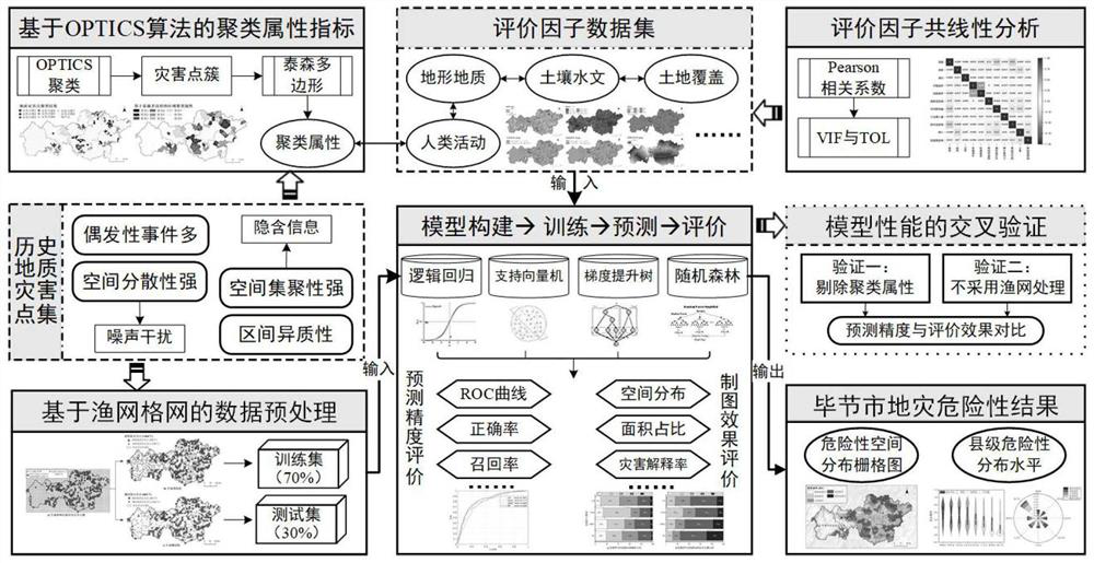
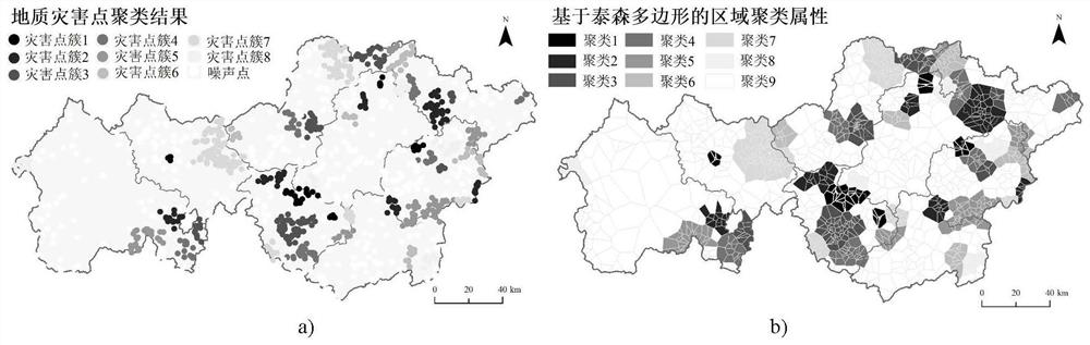
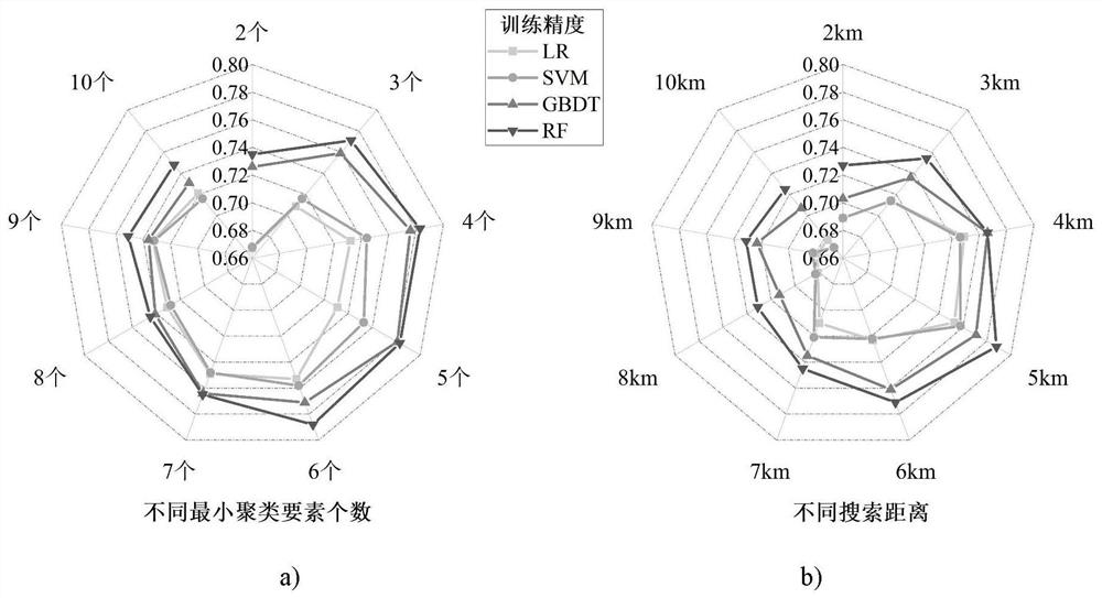
[0046] The present invention provides a method for assessing the risk of geological disasters in consideration of spatial distribution characteristics. The technical content of the present invention will be described below by taking the risk assessment of geological disasters in Bijie City, Guizhou Province as an ex...


PUM


Abstract

The invention discloses a geological disaster risk comprehensive evaluation method considering spatial distribution characteristics. Comprising the following steps: aiming at spatial aggregation and dispersion characteristics of historical geological disaster points, respectively proposing a data preprocessing method which uses a clustering algorithm to extract regional clustering attributes as evaluation indexes and is based on a fishing net grid; constructing a model based on a multi-machine learning algorithm of logistic regression (LR), a support vector machine (SVM), a gradient boosting tree (GBDT) and a random forest (RF); determining an optimal model by comparing the model prediction precision with the map evaluation effect, and drawing a dangerous map; meanwhile, providing an experimental scheme for testing the technical reliability. According to the method, the model evaluation precision can be remarkably improved, the model evaluation performance can be enhanced, and the geological disaster risk map with more accurate prediction and better quality can be generated, so that a decision basis conforming to the actual situation is provided for disaster risk prevention and control planning work.

Description

technical field [0001] The invention belongs to the technical field of geological disaster engineering, and in particular relates to a method and device for comprehensively evaluating the risk of geological disasters in consideration of spatial distribution characteristics. Background technique [0002] In recent years, under the background of intensified global climate change and frequent occurrence of extreme weather events, geological disasters in my country have shown a trend of frequent occurrence, and some areas may aggravate. The suddenness, mass, complexity, and uncertainty of geological disasters have brought many difficulties to pre-disaster investigation and prevention and post-disaster emergency response, and have seriously threatened people's lives and property, regional economic development, and ecological environment security. Therefore, the detailed and precise evaluation results of geological hazard hazards are particularly important, which provide a reliabl...

Claims


Application Information

Patent Timeline
IPC IPC(8): G06Q10/06G06Q50/26G06N20/00G06K9/62
CPCG06Q10/06393G06Q50/26G06N20/00G06F18/211G06F18/23G06F18/24323
Inventor 杨赛霓姚可桢
Owner BEIJING NORMAL UNIVERSITY
Why Eureka
Try Eureka